1. Introduction
Transport infrastructure, particularly roads, are traditionally seen as a key strategy to foster regional development (Ivanova, 2003) and economic growth (Cantos et al., 2005), as well as to overcome spatial inequalities, which are commonly seen as limits to reaching prosperity (United Nations, 2020). Inequalities typically manifest in demographic terms, e.g., in imbalanced population distribution. They reflect the vicious cycle of ageing, outmigration, and demographic decline, which eventually lead to less-developed regions, according to the classic approach that associates development with a linear process of growth (Copus et al., 2020). Essentially, regional development in rural areas consists of providing and securing fundamental services (Slätmo et al., 2022).
In island settings, transport infrastructure plays a vital role in the debates about future development paths. Such debates are typically shaped by the dichotomy fixed links (i.e. roads, bridges, and tunnels) vs. ferry connections (Baldacchino, 2007). This paper focuses on the Faroe Islands, an 18-island archipelago in the North Atlantic, where a massive tunnel-building project started six decades ago aiming to reverse negative demographic trends and outmigration. Significantly, one of the most recent versions of the Faroese Transport Strategy (Landsverk, 2012), issued by the public works authority Landsverk, is entitled Føroyar sum ein býur (The Faroes as One City). Such a vision has progressively been materialized through the construction of fixed links that connect the major islands. Yet, the question of whether (or to what extent) the very goals of stopping and reverting population losses in the most remote municipalities, as well as of avoiding greater concentration in the capital of Tórshavn, are achieved, remains open. This is precisely the endeavour of this paper.
1.1. Research Design
In this paper, we address the following research question: How has transport infrastructure, and particularly fixed links, influenced, both in positive and negative terms, Faroese demographic and spatial development over the last six decades? More specifically, we investigate to what extent can recent demographic and spatial development in the Faroe Islands be explained by the replacement of ferry lines by fixed links.
This question dictates our initial hypothesis, based on analysis of the existing literature, that road network development and particularly (subsea) tunnel construction has contributed to keep a positive demographic balance in the archipelago and to contain the traditional emigration flow. Yet, this strategy might have created internal imbalances within the country, i.e., between communities, municipalities, islands and regions; and that such imbalances might ultimately have socio-spatial consequences.
Temporally this paper is focused on the second half of the twentieth century and the first two decades of the twenty-first century. The analysis of the population record starts just after World War II with the 1950 census, well before the first tunnels were constructed in the early 1960s. As for its spatial scope, the paper addresses the entire archipelago of 1,399 km², with the longest distance north-south of 118 kilometres and east-west of 79 kilometres. We will approach the case study from a regional perspective, meaning that results will be broken down according to a multi-scalar approach of regions, municipalities, and communities.
This paper is structured in five sections. After this introduction, section 2 summarizes a brief state-of-the-art of transport infrastructure studies and demographic and spatial development in island environments with special emphasis in the Fennoscandian context. In section 3, we explain how data were collected and generated as well as what methods were used. Section 4 presents the results and is divided into two subsections devoted to an analysis of the data, including graphic visualisation in maps and charts. In section 5, we discuss the qualitative data results from our fieldwork. We position them in academic discussions about transport infrastructure development in island environments, and specifically within the debate between fixed links and ferry lines. We interpret the outcome in the framework of regional development and of centre-periphery relationships. Finally, in the conclusion, the research question is revisited, and the main results are wrapped-up.
1.2. Geography, Demography, and Regional Development in the Faroe Islands
The Faroe Islands are a primarily basalt archipelago of volcanic origin located equidistant from Iceland, Scotland, and Norway in the North Atlantic. Being at a latitude of 62° North, and located south of the 10°C July isotherm, the Faroes have subarctic character; yet, politically they are considered as part of the Arctic. The country is a full-right member of the Arctic Council (The Prime Minister’s Office, 2013), and it is included in the assessment area of the Arctic Human Development Report (AHDR), the Arctic Monitoring and Assessment Programme (AMAP), and the Conservation of Arctic Flora and Fauna (CAFF).
The Faroe Islands are an autonomous territory within the Kingdom of Denmark that have been self-governing since 1948. Since the last supplement to the Home Rule Act was passed in 2005, the Faroese government has control of all matters except defence, police, judiciary, and foreign affairs, which remains under the government in Copenhagen (Nielsen, 2020). Administratively, the archipelago is divided into 29 municipalities (kommunur). In addition, there exists a regional division in seven sýslur, but with no legal significance. The current 54,522 inhabitants (Statistics Faroe Islands, 2023), are spread across the inhabited 17 islands. There are significant differences in population distribution among the islands. Streymoy, where Tórshavn is located, has almost half the population of the islands and approximately twice as many people as Eysturoy, the second-most populous island. The rest of the territory is sparsely populated, with seven islands having populations of less than 100 people (Heleniak, 2020). The archipelago has a population density of almost 40 inhab./km2, which is fairly high by Arctic standards (Jungsberg et al., 2019).
Until the nineteenth century, the Faroese population grew slowly in small settlements and the economy was based on agriculture, mostly sheep farming (Numminen, 2010). Lying in the middle of the ocean, the archipelago has traditionally shown high ratios of outmigration yet combined with high ratios of return migration (Hayfield, 2017). The main destination typically was (and still is) Denmark, the former metropolis (Hamilton et al., 2004). The population has been steadily increasing since the mid-nineteenth century as fishing became the central economic activity of the archipelago (Guttesen, 1996; Slätmo et al., 2022). This sector has suffered continuous boom-and-bust cycles and, consequently, it has determined the archipelago’s recent demographic development, particularly the migration balance. The last decades have witnessed a population growth of about 3%, mainly due to a positive natural increase. Compared to other Western countries and even with Nordic countries, the Faroe Islands have a high fertility rate, although it has dropped rapidly since 2018 (annual rate of 2.5) to the current 2.05 (Statistics Faroe Islands, 2023). Overall, the archipelago’s population numbers are expected to stabilize in the next decades, according to the forecast by the Faroese Statistical Office (Hagstova Føroya, 2022).
The mountainous character of the islands has historically conditioned life (and, therefore, communications) in the archipelago. Row boats were the only possibility to connect the islands’ communities, which are located in well-protected bays at the coastline (Numminen, 2010). Even when there existed a dense network of paths connecting settlements (c.f. Gaini & Jacobsen, 2008), communication within the islands often happened over sea connections between harbours. As soon as it was technically possible, tunnels were drilled to overcome mountain passes between villages. Modern roads were therefore possible thanks to tunnels. The next step was to bring roads beyond single islands and connect them using fixed links.
Transport infrastructure has marked the country’s development agenda in contemporary times. After World War II, a national policy of local development called bygdamenning (development of villages) was established to counter both strong emigration ratios (Guttesen, 1996) and a trend of people leaving smaller villages for urban centres and, thus, eroding the village-based social structure. Bygdamenning pursued a universal provision of public services at the local level as a way to guarantee equal benefits and opportunities (Numminen, 2010). In practice, this consisted of a strategy to foster widespread industrial development, first by constructing roads, and in the early 1980s by allocating fish-processing infrastructure to generate growth in the remote villages (Hovgaard, 2001 in Niclasen, 2015). Yet, bygdamenning has been described as “a benevolent gesture, rather than a policy to sustain rural communities and offset rural depopulation” (Guttesen, 1996, p. 100).
Everything changed in the Faroe Islands after the fisheries collapse in 1989, including regional development policy. In the late 1990s, bygdamenning was replaced by økismenning, a top-down, regional development policy or “development of periphery” (Niclasen, 2015, p. 6) that sought to establish regional entities to assume equally distributed public service functions (Bærenholdt, 2002). In 2001, the central government officially set the goal to reduce the number of municipalities to 7-9 to become sustainable, decentralised entities that could drive forward the økismenning strategy. Nonetheless, the number of entities dropped from 48 in 2001 to the current 29 (í Jakupsstovu, 2017). It has been argued that økismenning did not fully succeed due to political reasons (Eythórsson et al., 2014; í Jakupsstovu, 2017).
2. Transport Infrastructures and Regional Development in Island Environments under the Centre-Periphery Approach.
According to the centre-periphery theory (Shils, 1961/2015), there exist inequalities between territories which are spatially manifested in terms of power, including material and non-material aspects (Hannerz, 2015). Such inequalities have often become exacerbated in the context of neoliberalism, which increases subordination relationships (Harvey, 1985). Even when the association of the conditions of periphery and remote place is arguable, the latter being an “alterity posed out of the spatial and conceptual continuum level and enacted in metropolitan spaces” (Membretti et al., 2022, p. 19), islands have been typically identified with remote and/or peripheral places:
In the center, an acceleration of time and history; in the peripheries, a corresponding retardation. In the growing mainland centers progress, modernity, and development; in islanded places the ‘good old days’, even utopias, an imagined past that adds contour and meaning to modernity but is accessible only through memory or deliberate reconstruction. (Ronström, 2021, p. 291)
Ronström refers to the notion of islandness to better understand island singularities. She argues that “rather than a ‘natural’ intrinsic quality, remoteness is a consequence of a fundamental cultural asymmetry in a global archipelagic system” (Ronström, 2021, p. 291). Vannini (2011), in turn, writes in terms of insulation vs. isolation when it comes to mobility and immobility in islands and coastal communities. Both terms are to be understood in a complementary relationship, the former being positively connoted, i.e., associated to “feelings of protection, safety, distinction, and disconnection,” whereas the latter is linked to the negative notions of “vulnerability, marginality, and inescapability” (pp. 257-258).
In order to compensate for social and spatial inequalities in both the mainland and island environments, development strategies have been conceived and applied over the last decades worldwide. The concept of development has become increasingly complex, particularly after the introduction of the notion of sustainable development (Rabie, 2016). In spite of this, demographic and economic growth has traditionally been viewed as a means to reach the ultimate goal of increasing the well-being and the quality of life for a given group of people.
Regional development aims to counter centre-periphery inequalities (Nijkamp & Abreu, 2009). The classic notion of regional development includes building infrastructure as one of its main drivers. Thus, transport infrastructures have traditionally been seen as a powerful tool to reduce spatial inequalities. In specific terms, connecting urban and rural areas through infrastructure linkages enables the mobility of people and goods, therefore, their access to jobs. This is particularly relevant in rural areas, where typical vicious circles contribute to economic stagnation and population decline (Bisaschi et al., 2021): “Better and shorter roads may expand the geographical scope of job opportunities in traditional rural extraction industries such as farming, fishing, logging or mining, public services such as education or health, and various small businesses and entrepreneurial enterprises that provide jobs” (Bjarnasson, 2021, p. 371). Yet, infrastructure alone cannot guarantee development. The opposite situation might happen, if infrastructure becomes a factor reinforcing spatial inequalities. In the latter case, they deepen rather than mitigate ‘left-behind-ness’ (Gansauer et al., 2023).
In island environments, the expansion of transport infrastructure is largely conditioned by geographical features. The debate between so-called ‘fixed links’ (i.e., bridges, tunnels) and ferry connections typically mark public agendas (Baldacchino, 2007). What is relevant here is the argument that replacing ferry services with bridges or tunnels is associated with agglomeration economies, productivity increases (Venables, 2007), and, ultimately, with population growth on islands (Bjarnasson, 2021). Whereas ferry services are more dependent on weather conditions or other circumstances, they could have become more reliable when applying the notion of transit-oriented development (Cervero, 2004) to a ferry-oriented management (Leung et al., 2017). These models reinforce the idea of fostering development, in terms of growth, to an island territory by putting transport infrastructures at the centre of this development. Island territories have been classified according to their transport connectivity degree, depending on the presence of fixed links (fully infrastructure-connected) or their absence (non-infrastructure-connected) (Leung et al., 2017).
Most of the studies about island connectivity focus on the development of fixed links between the mainland and (coastal) islands or archipelagos, e.g., in Canada (Baldacchino, 2007), Hong-Kong (Lau et al., 2023; Leung et al., 2017), and Norway (Díez Gutiérrez et al., 2015; Tveter, 2018). Due to both their location and geographical features, the Faroe Islands differ from the latter cases. The archipelago consists of many closely-located small islands, isolated from both the continent (Scandinavian Peninsula) and any other landmasses (Iceland, Great Britain). In the Faroe Islands, the government ended the debate between ferries and fixed links in favour of the latter since the first bridge was built to connect the largest islands of Streymoy and Eysturoy in 1973. Two further causeways followed. Decades later, in 2002, the first subsea tunnel was built, followed by two more subsea tunnels (inaugurated in 2006 and 2020), and the last one, which was inaugurated in December 2023.
The Faroese transport infrastructure system and its manifold impacts has notably drawn attention of scholars from different disciplines in recent years. Hokwerda (2017) analyses socio-economic impacts of sub-sea tunnels on land-use and mobility issues from the perspective of urban planning. He identifies an on-going mainlandization process that resulted from connecting Tórshavn and the largest islands of Streymoy and Eysturoy with the neighbouring islands of Vágar and Borðoy. Consequences are an increase of commuting, not necessarily in terms of number of people but of transits, and urban sprawl. Dahl (2020) applied a feminist approach to investigate relationships between gender and transport infrastructure in the Faroe Islands and highlights that “interconnecting infrastructure planning on the Faroe Islands is a gendered development project” (Dahl, 2020, p. 2). In her work, Dahl argues that, having become an infrastructural project in itself, the Faroe Islands have suffered a centralisation process resulting “in the construction of a center-periphery relation” where “sub-sea tunnels themselves are named after the island they connect to the center island” Streymoy, where the capital town of Torshavn is located (Dahl, 2020, p. 11). The entanglements of transport infrastructures and tourism have been studied by Chan Santana et al. (2022), who suggest that, thus far, Faroese authorities have underestimated the disruptive potential of tourism, which is a growing phenomenon in the archipelago. Not least, for the topics of insularity and centre-periphery relationships, Hayfield and Pristed Nielsen (2022) reflect on the islandness character of the isle of Suðoroy, which is the only large island lacking fixed links, by arguing that mobility is entangled with island belonging, and that such feelings might change if the ferry was substituted by a road connection.
Being part of the Arctic and Nordic context, the Faroe Islands have features (such as a higher population density) that makes their socioeconomic dynamics work distinctively. Yet, there are studies from Iceland and Northern Fennoscandia that shed light on similar regional development challenges. Tveter (2018) concludes that fixed links in the Stavanger area have contributed to lower island housing prices and that population growth could, to a considerable extent, be attributed to urban people taking advantage of the possibility of commuting back to the mainland. In his study in Northeast Iceland, Bjarnasson (2021) suggests that connecting urban and rural areas might generate increased commuting into rural areas (in addition to the urban workers’ flow to rural dwellings). Likewise, he argues that roads may lie behind the positive demographic dynamics in the area (notably parity in net migration), which lead the author to speculate about an end of long-term population decline.
3. Data and Methods
This investigation is based on a combination of quantitative and qualitative methods and data. Whereas the former ones lie at the backbone of the research process, the latter are decisive to interpret the outcome of the data analysis. Therefore, the paper takes a mixed-methods approach. According to Creswell (2012), this is a procedure for collecting, analysing, and mixing both quantitative and qualitative research and methods in a single study to understand a research problem. In this case, the research question (see section 1.1 in Ch. 1) can ultimately be answered if one attends both quantitative and qualitative approaches. Whereas quantitative data refers here to demographic statistical data as well as data related to transport infrastructures, e.g., road network length. Qualitative data are on-site observations during fieldwork as well as expert interviews.
3.1. The Quantitative Approach
Statistical data was collected to build a comprehensive picture of demographic development since the mid-twentieth century in the Faroe Islands. Datasets are publicly available at the website of the Faroese Statistical Office Hagstova Føroya. The main variable we use is the local population record at settlement and municipality scale between 1950-2023. Further, we used demographic data on migration balances and population structure (age and sex) at the regional and national levels. These data, however, are available only from 1985 onwards. Consequently, these data play a complementary role in this paper. As we are primarily interested in investigating population imbalances, we use the rank size rule by Zipf (Bretagnolle et al., 2001) to understand settlement system balance, and whether it has changed alongside the selected time periods. Whereas one can argue that the use of the rank size rule has declined in recent years, there are examples of its continued application, e.g., Xu’s et al. (2021) analysis of the Chinese port system.
To create an inventory of transport infrastructures, we collected data related to roads (including tunnels and subsea tunnels), ports, airports, and helipads. As we focus on a long period of time, we strived for past records. Yet, historical data on transport infrastructures in the Faroe Islands is fragmented and not easy to obtain. Online available publications are scarce and present processed data only (c.f. Gaini & Jacobsen, 2008; Guttesen, 1996). In practice, most of the historical data about transport infrastructures we have integrated into our analysis, including years of construction of roads, ports, and heliports, was obtained from maps provided by Landsverk. Other complementary sources, including maps, websites, and blog posts were used to fill existing gaps.
Analysing links between population development and transport infrastructure necessitates gathering and incorporating traffic-related data. Here, the same problem as above arises: namely, limited data availability and fragmentation both in terms of time and space. First, there is no modal share for the Faroe Islands. This indicator, which is regularly used in transport research and mobility management (Strommer et al., 2023), would have provided interesting insights from the current whole picture of the transport situation. Second, commuting data is available from the 2011 census only, which does not allow any kind of comparison across time. Alternatively, we compiled and analysed the database from the Faroese public transport company SSL, which provides an extensive record on monthly bus and ferry passenger numbers within a short time series (2016-present day). Further available data include an account of the number of registered vehicles since 2009 at island level, as well as since 1980 at national level.
Selected datasets were correspondingly edited, i.e., series were cleaned and adapted to our time period, and then integrated into a Geographical Information System (GIS) to generate cartographic visualisations combining demographic data with transport infrastructures. Likewise, charts were created. At this point, a qualitative approach comes into play.
3.2. The Qualitative Approach
Fieldwork was conducted in two short stages of (two weeks altogether) in 2023 (in spring and in fall). The goal of the stages was to visit and to use some of the existing and planned transport infrastructure objects before, during, and after data compilation and analysis, including the airport, most of the roads, and two ferry lines. Additionally, we had the chance to drive through the Norður um Fjall tunnel, which is currently under construction, with the guidance of the chief engineer. During our stages, fieldwork observations included spontaneous conversations as well as previously arranged informal meetings with local residents. Pictures, videos, and notes were correspondingly archived and fed into our interpretation of results.
The main piece of qualitative fieldwork included four semi-structured interviews. They were conceived as an open dialogue based on a previously defined question catalogue. In the first stage, the catalogue was inspired by a number of general topics associated with transport infrastructure (actual usage, maintenance, sustainability and well-being, temporality, promises and expectations, failures and disenchantment). A second step consisted in conceiving tailored catalogues to each of the interviews. Topics were adjusted to the infrastructure objects and projects in the Faroe Islands, i.e., sub-sea tunnels, roads, ferry lines as well as to this paper’s focus on demography and regional development over the last six decades. Finally, specific questions were formulated according to the interviewees’ expertise and affiliation. The semi-structured interviews allowed new ideas to be introduced by the interviewees (Knott et al., 2022).
A total of five persons participated in the interviews, including practitioners from public companies (one from Landsverk and two from SSL), one representative from a non-governmental organization (Association of Outer Islands), and one from academia (University of the Faroe Islands). Interviewees (three female and two male) were selected prior to fieldwork on the basis of previous research. All conversations (except for the interview with the representatives of SSL, which took place online) were conducted on-site at the Landsverk headquarters in Tórshavn or at the Faculty of History and Social Sciences of the University of the Faroe Islands. All interviews were recorded, transcribed, and anonymized. In chapter 5, short excerpts from the interviews are included. They provide crucial insights to our arguments from authoritative voices; however, the limited number of interviews does not allow to draw empirically based conclusions. They are coded using numbers 1 (Landsverk), 2 (SSL), 3 (University of the Faroe Islands) and 4 (Association of Outer Islands).
4. Entanglements of Faroese Demography and Transport Infrastructures: A Chronological Perspective (1950-2023)
4.1. The Whole Picture
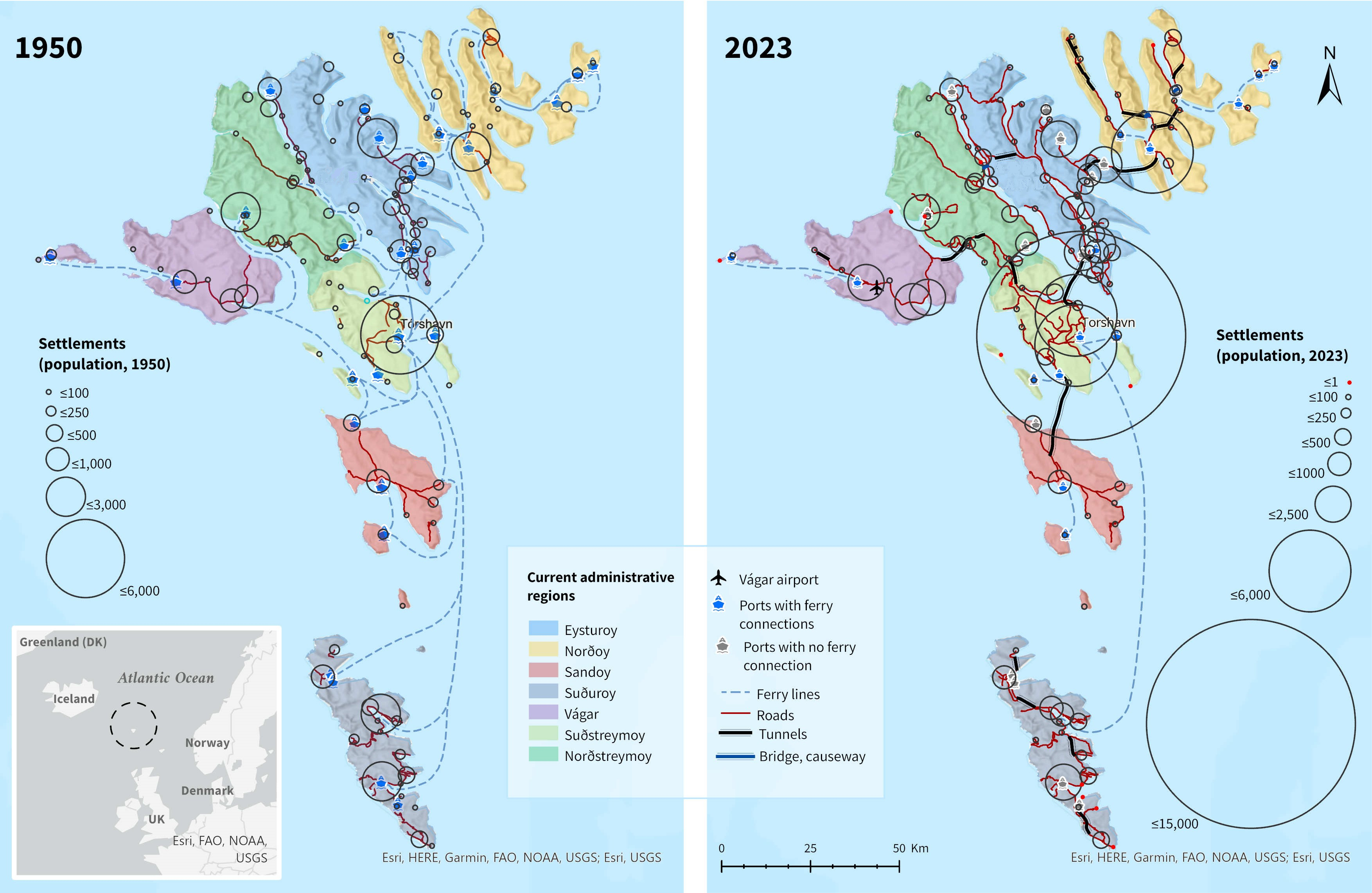
_and_existing_transport_infrastructures.jpg)
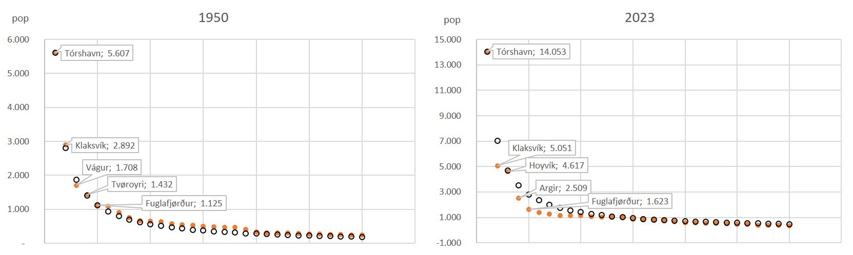
Figure 1 maps show a deep transformation of both the Faroese transportation and settlement network over the last six decades. Between 1950 and end of 2023, the country’s population increased by 1.7 times; significantly, the bulk of inhabitants has become concentrated in Tórshavn and the adjacent towns of Hoyvík and Argir (18.8% of the total population in 1950 vs. 39% in 2023). Figure 2 charts confirm what can be seen in the maps, namely to what extent the settlement system has become unbalanced in relation to the situation in the mid-twentieth century. The charts display a rank-size calculation including the 30 largest settlements of the archipelago in 1950 and 2023. The degree of overlap observed on the expected numbers is astonishing for 1950, e.g., Klaksvík had exactly half of the population of Tórshavn. In 2023, the opposite occurs; i.e., observed numbers (orange dots in the charts) stay well below the expected ones (blank points in the charts) among the top ten settlements.
Figure 1 maps show at least two further phenomena reflecting the trend towards population concentration. First, a population continuum alongside the so-called growth axis or central region (Hovgaard & Kristiansen, 2008) connecting Tórshavn with Klaksvík through the eastern shore of the Skálafjørður, on the island of Eysturoy, clearly stands out in 2023. Significantly, the circle cloud is already identifiable on the 1950 map, i.e., well before fixed links replaced ferry connections. Second, 14 depopulated settlements or settlements counting one registered inhabitant are tracked in 2023. In most of the cases, these settlements were small hamlets numbering less than 50 people in 1950. Those depopulated settlements that are accessible by motor vehicle, such as Múli in Borðoy in the Norðoy region, have been preserved. Well-kept houses, crops, and pastures are testimonials that physical abandonment has not taken place.
As for the road network, total length has more than doubled from 287 km in 1950 to 645 km (incl. 66 km of tunnels) in 2023. Correspondingly, the ratio of km per person grew from 9 to almost 12 meters per person. Though roads to the most populated places in all major islands were already built in 1950, they did not constitute a true network, since sections were isolated from each other. This can be largely explained by the absence of fixed links, which enabled road connection between sections. The 2023 map shows 22 tunnels, including four subsea tunnels, currently in operation. This makes a ratio of 1.2 meters of tunnel per capita. All in all, the maps graphically express an overall substitution of ferry lines by fixed links. Ferry lines in 1950 numbered at least 30 (c.f. Roberts, 2023). Most of them were post-boat regular services accepting passengers onboard. In 2023, six lines are being operated by the public transportation company SSL. Consequently, the number of harbours hosting regular ferry services has massively dropped.
As for aviation, the only airport in Faroese territory already existed in 1950 after being built by the British occupying forces during World War II. Yet, the airport was only put into service for commercial aviation in 1963 (the same year of the opening of the first tunnel built in the Faroe Islands). Until then, the archipelago was reachable only by sea. Helicopters have become part of the modern transportation system, including passengers and cargo. They are critical for moving both people and goods to the smallest outer islands as well as for search and rescue. Thirteen out of the existing sixteen helipads are owned and maintained by Landsverk. All of them were built in the first half of the 1980s. We have not included them in Figure 1 maps due to symbol overlap.
4.2. Regional Insights
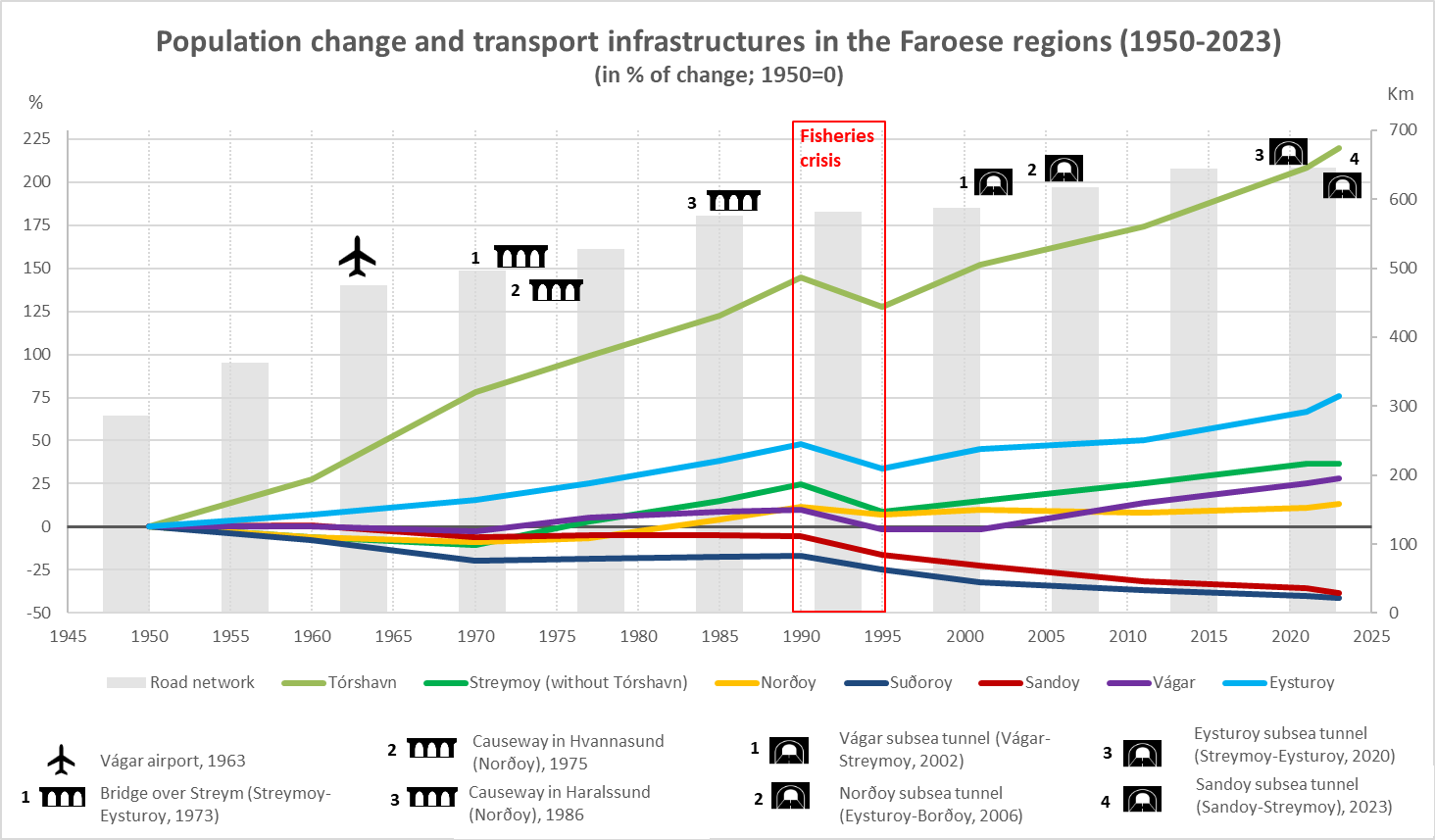
Figure 3 chart shows how both population and transport infrastructures have evolved over time in the seven statistical regions (sýslur). Population numbers (left axis in the chart) are indexed to enable interregional comparability. The right axis shows the overall road network length (in kms) over the years. Icons indicating construction year and location of the fixed links connecting the islands can be seen in the chart. Last, the fishery crisis is highlighted as it had drastic demographic consequences: the country lost 10 percent of its population in six years, 1989-1995. When interpreting the chart, Figure 1 maps are to be borne in mind, since the colour code is the same for regions. There exists a single slight divergence between the chart and the map. Unlike in the maps, the southern part of Streymoy has not been used in the chart, since its borders do not coincide with municipalities, the tier where historical population records are available. However, discrepancies between Tórshavn municipality and South Streymoy are insignificant both in terms of area and number of inhabitants.

Figure 3 shows a large gap between Tórshavn municipality, which has more than tripled in population since 1950, and the rest of the communes. A more detailed observation, however, reveals a significant north-south divide within the archipelago. Whereas the southern islands of Sandoy and Suðoroy have been losing population since the mid-twentieth century, the rest of the regions, corresponding to the islands located at the centre and the north of the archipelago, have been experiencing population increases, yet at different paces. There are important differences within regions as well. This is clearly traceable when focusing on municipalities as an intermediate tier of analysis between settlements and regions. Yet, as the number of communes has been reduced in recent decades (see Section 1), comparisons must be taken cautiously. Likewise, careful readings are necessary when it comes to large municipalities with heavy population imbalances and/or territorial discontinuity. This is the case of Klaksvíkar in Norðoy, Sunda in Eysturoy-Streymoy, and Runavíkar in Eysturoy.
The island of Eysturoy shows the most intensive growth after Tórshavn, which leaves Streymoy (without the capital town) clearly third in the chart. All six municipalities in Eysturoy have experienced population increases, meaning that not only those settlements located along the Skálafjørður on the growth axis (see previous section) have benefited in demographic terms. Marked contrasts can be noted in the easternmost region of Norðoy instead: whereas Klaksvík and two further municipalities have growth, the peripheral Fugloyar and Kunoyar, both lacking fixed links, have been continuously losing population. In the chart, this contrast results with weak aggregate growth. The westernmost island of Vágar clearly shows the effects of the 2002 subsea tunnel, which has been a game changer. Since its opening, the island’s two municipalities, which were previously struggling to maintain their population numbers, have experienced growth, yet with a notable difference in favour of the municipality located closer to the tunnel and to Tórshavn. Last, population losses in the southern islands are more visible at the regional level than they are at the settlement level (see Fig. 1). Apparently, roads and tunnels have not contributed to slowing down negative trends. A substantial part of the road network was already built on both isles in 1950, particularly in Sandoy. In Suðoroy, two out of the four tunnels currently being operated were built before 1970.
Exploring beyond population record is necessary in order to obtain a much richer demographic picture. A comparison between 1985 and 2022 focusing on population structure and population dynamics should help in this endeavour. Three conclusions can be drawn in this regard. First, net migration balances are markedly negative in all regions, particularly in the southern isles (both -14%), whereas in the central regions it is close to 0 (e.g., Eysturoy -1%; Vágar -3%). Second, all regions suffer from an unbalanced population structure concerning gender, with more male than females. This gap has been closing from 1985 in all regions (particularly in Norðoy) except in the southern isles of Sandoy and Suðoroy, where it has become even greater. Third, average age numbers have greatly increased in recent decades, the least in Vágar (13%) and between 20% and 30% in the rest of the regions. If one examines these numbers with road network development, a conclusion can be drawn: since 1985, the road network has grown unevenly across regions, ranging from +42% in Norðoy to 0% in the southern islands (the reason has been mentioned above). In this period, tunnels were mainly built in the central regions (northern and southern Streymoy).
Returning to Figure 3, when it comes to the influence of fixed links in the archipelago’s demographic behaviour, their impact has been gradual rather than sudden except for the Vágar (2002) and Eysturoy (2020) subsea tunnels. The Eysturoy tunnel has led to clear population increase in Eysturoy, but also in Norðoy, where the demographic impact of the 2006 tunnel cannot be traced in the chart, probably due to the above-mentioned internal disparities in this region. The whole picture conveys one clear message: Whereas fixed links seem to have strengthened all those connected territories (at different scales), Tórshavn clearly stands out as the most benefited municipality in terms of population growth (Fig 1) at costs of the mid-size settlements and municipalities (Fig 2). Southern islands and particularly small peripheral islands (outer islands) are the other side of the coin in this demographic imbalance.
5. Discussion: Fixed Links as Double-Edge Swords?
Results from the previous chapter suggest that sixty years of tunnel development in the Faroe Islands have led to an overall population growth and, simultaneously, to internal demographic imbalances. On this basis, and under the lens of qualitative data, in this section we address some space-related consequences of such infrastructural and demographic transformations. Namely, three issues will be discussed: (i) the shift towards individual mobility patterns; (ii) the re-configuration of centre-periphery relationships; and (iii) transformations of the archipelago’s insularity.
5.1. The Shift Towards Individual Mobility Patterns
The ferry vs. fixed links dichotomy has manifold impacts on mobility behaviour. Whereas ferries in the Faroes are a public service, tunnels are essentially designed to allow private cars moving around the archipelago. Even when the latter statement is not undisputed (in the end, one can travel with their own car on the ferry, and new bus lines are being set through the subsea tunnels), transit data show a clear trend in favour of individual mobility in the Faroe Islands. Just two examples: In 2023, the number of registered cars was 2.5 times higher than in 1980 (Statistics Faroe Islands, 2023). Between 2016 and 2022, all ferry lines (except for the one to the small island Hestur) have increased the number of cars being moved. In the same period, twelve out of eighteen regional bus lines have lost passengers. The argument was posed by the CEO of the SSL during our interview:
I think there is a kind of contradiction. The owners of subsea tunnels are (…) private companies owned by the government. They do business, they build the tunnels, and they exploit them. But they take loans that should be paid back. So, they want cars in the tunnels, because they pay the tunnels back. And if we take buses and say to people: “leave the cars at home, we will drive you in the bus…” They want cars in the tunnels, not necessarily buses. But the government has a green profile and wants to foster public transport. That’s one hand, but with the other hand they want the tunnels to be economically viable. (Interview 2)
Fostering individual mobility has further spatial effects with social and cultural consequences. Urban sprawl, car-dependency, dormitory villages, and supermarket areas outside the settlements have been reported in the Faroe Islands, particularly on those directly affected by subsea tunnels, such as in Vágar and Borðoy (c.f. Hokwerda, 2017).
5.2. Re-Configuration of Centre-Periphery Relationships
Fixed links have reconfigured spatial hierarchies within the archipelago and between the islands. Connecting an island to the road network automatically excludes the islands not connected by fixed links. This is the ultimate reason why the Association of Outer Islands has been advocating for better connections (ideally roads and tunnels or better ports and ferry connections as an alternative) to the small islands. It unsuccessfully pushed for an alternative route through Kalsoy for the Norðoy Tunnel. Likewise, it wanted a new port in Svínoy and a tunnel to connect it with the town of the same name, but it did not manage to convince decision-makers. Currently, it is struggling to bring the Suðoroy tunnel through Skúgvoy.
All these examples contradict the official line of argument associating tunnels with equal opportunities in terms of mobility and, ultimately, work and liveability for everyone across the entire archipelago: “investments [are] needed to ensure that the islands reach a level of interconnectedness that makes the whole country feel as a single unit” (Mc Birnie & Mikkelsen, 2011, p. 7). Tunnels are “important assets for the further development of (…) society” (Samuelsen & Grøv, 2017, p. 6). Arguments in favour of tunnels were mentioned in all our interviews:
Building tunnels and bridges it’s not about connecting each other, it’s about opportunities. Work opportunities, education opportunities… being able to participate in what’s happening in the central area, (…) so it’s about opportunities as well, it’s about survival in place. One person from Suðoroy told me: “either they -the authorities- need to give us jobs or they need to give us the way to get the jobs.” (Interview 3)
Well-being depends on transportation, on how you can come to the services, because in the rural area, everything you need is on the mainland, doctor, leisure for the youth, social life. You should be able to go and come back several times a day (. …) It’s very important. If you don’t have adequate transportation, you can’t develop anything, e.g., agricultural products (. …) Everything depends on transportation. (Interview 4)
In practice, however, islands compete over transport infrastructures. This not only affects subsea tunnels, but also ferry lines. The struggle for infrastructures is, indeed, unequal. The fact that islands are deeply uneven in terms of physical and demographic size (the latter should be understood in terms of potential voters) makes the difference. The case of the former ferry line to Sandoy (population: 1,273) via Hestur (population: 15) is particularly enlightening:
It was a capacity issue and then pressure from Sandoy. They’re a lot of more people, and they are the factor the capacity of the ship was raised to 100. So they lobbied to get rid of the early morning connection through Hestur, because it was delayed by 20 min. to the mainland. They put pressure on the politicians in 2016, and they said okay, we will sacrifice the people of Hestur in favour of you. (Interview 2)
Ultimately, what lies behind the motto the “Faroes as one city” is an attempt to get rid of the status of periphery by connecting every single settlement to the centre in less than one hour of travel time (c.f. Mc Birnie & Mikkelsen, 2011; Sjúrðarson, 2022). This strategy fails when it comes to the outer islands, which presumably will never be connected via fixed links to the largest islands. Consequently, the latter will never escape from their peripheral status. Yet, this issue has a deeper spatial dimension. The fact that, in the Faroe Islands, rural areas are commonly associated to non-connected places in terms of roads and tunnels, allows us to speculate upon the intention of the government to get rid of the Faroese rural areas, bearing in mind the motto:
The rural areas in the Faroe Islands are periphery areas, i.e., everything longer than 1 hour from Tórshavn. Not even Kunoy can be considered as ‘rural’ [Kunoy is connected with a causeway]. Dalur [Sandoy] is a place we call ‘rural’ because it’s difficult to drive. Now they are building a tunnel and then it won’t be rural anymore. Examples of rural areas are Gjógv [Eysturoy], because they have a road that most of the time is closed. Saksun and Tjørnuvík in Streymoy are rural. (Interview 4)
As argued in the introduction, the Faroe Islands have not succeeded in designing and implementing either national or regional development plans to counteract territorial inequalities. The interviewees highlighted this issue and tried to identify some explanatory reasons such as divergent historical trajectories compared to other Nordic countries:
When Denmark and some other Nordic countries started developing their nation state into a social democratic welfare state, the Faroe Islands weren’t at that point. They were still concerned about work. There was not enough work, because it’s very remote. So, they needed to ensure that there is (…) first of all work. (Interview 3)
As a matter of fact, transport infrastructures were mentioned as a driving force when it comes to the very idea of development:
In Norway, they have district or regional policy, when they have made a plan, very structured, in a bureaucratic way striving to allow people to live all around Norway (…) We don’t have such specific tools (. …) We want to connect all the islands. At a great cost, but this is a long-term investment. (Interview 1)
Administrative divisions play a crucial role in development issues. The country did not manage to deeply restructure its municipal division; instead, individual mergers have resulted in a non-consistent mixture between larger and small municipalities. This seems to have brought both positive and negative effects. On the one hand, Slätmo et al. (2022) argue that, in the Faroe Islands, the subsidiarity principle might not be necessary in terms of service provision as long as the national government has the ability to incorporate local voices into their policies. On the other, however, this does not always happen, particularly in larger, peripheral municipalities: “We’ve tried to put the small municipalities together, e.g., Svínoy to Klaksvík. This resulted in a big problem; namely, that the local power is gone. They are sitting and waiting for the municipality to come and do things. They [the villages] have no money, no competences, nothing” (Interview 4).
5.3. Transformations of the Archipelago’s Insularity
As fixed links have removed the island barrier, population distribution patterns no longer depend on the individual island units. Not least, administrative divisions and development strategies have evolved regardless of the physical structure of the archipelago, as municipalities have been merged without considering territorial discontinuities. Removal of natural barriers with causeways, bridges and tunnels upon or beneath sea water might have eased mergers and regional reconfigurations. What further effects such a mainlandization process (Hokwerda, 2017), which “dissolves spatial boundaries and increases mutual dependency between villages and Tórshavn” (p. 46), has produced over local perceptions of islandness, is something it should be addressed in future investigations.
However, what seems indisputable is that the consequences of building fixed links in the Faroe Islands very much differ from those on islands located closely to mainland shores. In the latter, it has been argued that fixed links typically lead to a loss of islandness (Leung et al., 2017). In the former, islandness might suffer re-configurations as outer islands are being connected to the core or the mainland, which in terms of mobility, housing, cultural life etc. can be treated as a single spatial entity. The term island community, which was approved by the Scottish Parliament in 2017, and which has been used for other island environments such as Hong Kong (Leung et al., 2017), might be helpful to better understand such re-configurations. According to this definition, an island community “consists of two or more individuals, all of whom permanently inhabit an island (whether or not the same island), and is based on common interest, identity or geography” (Scottish Parliament, 2017, as cited in Leung et al., 2017, p. 2). Under this definition, the Faroe Islands might be understood as a single island community as ferry lines have been replaced by bridges and subsea tunnels, with the only exception of Suðoroy and the outer islands.
6. Conclusion
After comparing this paper’s findings with the research question (“How has transport infrastructure, and particularly fixed links, influenced, both in positive and negative terms, the Faroese demographic and spatial development over the last six decades?”), we found that modern road expansion, including fixed links, has coincided with a phase of steady demographic growth which was only interrupted during the fishery crisis in the early 1990s. Yet, as the road network expanded, demographic imbalances gradually appeared in favour of the capital of Tórshavn and the growth axis to Klaksvík at the expense of the rest of the country. Consequently, the Faroese urban system hierarchy has become weaker as rural areas in the periphery suffer from negative net migration balances, gender imbalances, and ageing. Importantly, internal differences are to be highlighted both in terms of space (i.e., between regions, islands, and municipalities) and time (e.g., impact after the construction of subsea tunnels).
What lies behind the relationship between infrastructural boom and demographic imbalances is the Faroese project of connecting islands by fixed links, which have gradually replaced ferry lines. This project materializes the vision of the “Faroes as one city” by the government and the public works company Landsverk. It is, therefore, a political endeavour to develop the archipelago into a cohesive system of islands or a single island community under the leadership of Tórshavn.
The case of the Faroe Islands shows that tunnels and transport infrastructure might not be enough to reach demographic balance, particularly if regional development tools and, ultimately, the spatial planning system enabling coordination between national, regional, and local scales are weak. Past debates on regional development strategies (bygdamenning vs. økismenning) and municipal mergers have eventually been subsumed by infrastructure projects through the construction of fixed links to create a cohesive labour market. Ultimately, ferry routes have been replaced because they do not fit the one hour commuting vision.
Acknowledgements
This work has been funded by the European Commission under the ERC Advance Grant “InfraNorth - Building Arctic Futures” (Agreement No. 885646).