
Background
Islands are any area of land smaller than a continent and surrounded by water which occur in oceans, seas, lakes, or rivers (Jędrusik, 2011). According to Veron et al. (2019) and Kueffer & Kinney (2017), islands, both continental and oceanic, are a hub of rare species that contribute significantly to global biodiversity. They are also key fish spawning and nursery places, migratory bird destinations, buffer zones against invasive alien plant species, and a home of Indigenous cultures (Millennium Ecosystem Assessment, MEA, 2005; Worku, 2018). This implies that islands contributed to the preservation of the world’s plant and animal species and the growth of socio-economic and cultural traditions. However, islands have been losing these attributes lately because of drastic environmental changes (MEA, 2005). Smil (2005) defines environmental change as an alteration or transformation of the natural environment (e.g., vegetation, soil, air, and water bodies) that affects human life either positively or negatively. For instance, human actions like reforestation, habitat preservation, and support for legislation that advances environmental protection initiatives contribute to environmental sustainability and socio-economic development (Clans et al., 2010). But we argue that while human activities contribute to the conservation of natural resources and promotion of economic and sociocultural developments, these developments are not easily maintained in the absence of environmentally friendly policies and practices, and sustainable usage customs. On the other hand, overgrazing, deforestation, consumption of fossil fuels, and the use of pesticides, among others, cause a depletion of natural resources and have a detrimental effect on human existence (Goudie, 2000). Thus, in this paper, the term ‘environmental change’ is used to represent any change that triggers harm to lake islands’ and their coastal areas’ environment and inhabitants’ lives.
In the Ethiopian Great Rift Valley, which is part of the East African Rift, there are seven large lakes (Hynes, 2002). Hynes reported that these lakes contain a lot of islands that have a decisive role in the islanders’ lives, the country’s socio-economic development, and biodiversity preservation. For instance, the islands of Lake Abijatta and Shalla are chief bird breeding sites that attract many tourists from around the world (Worku, 2018). Likewise, the holy monasteries and Christian relics on the islands of Lake Zway attract pilgrims and tourists (Wolde-Michael, 2017). Equally, the 37 islands in Lake Tana, which lies outside of the Ethiopian Great Rift, are home to monasteries with fascinating historical and religious records that have contributed to the expansion of tourism in the country (Cheesman, 1968). Besides, according to Solomon (2024), the islands in Lake Tana are known for their dense forest and rich agricultural and grazing land. This suggests that the majority of Ethiopia’s lake islands and their coastal areas are sources of agricultural and forest products, potential tourist destinations, storehouses of biodiversity, and repositories of historical and religious relics. However, the 1984-85 nationwide drought that disrupted the country’s natural resources and its citizens’ livelihoods, along with the demand for additional land for agriculture, grazing, settlement, construction materials, and energy supply from a rapidly growing population (2.7% per year), has significantly harmed the country’s natural resources, including those of the lake islands (Amare & Belay, 2015; Bradley, 2023). Consequently, many of Ethiopia’s lake islands have seen a notable decline in biodiversity and the loss of fertile soils and grazing lands. This environmental degradation has undermined the socio-economic foundations of the island inhabitants, such as the agricultural and tourism sectors, and has threatened their cultural traditions, forcing many islanders to abandon their cherished homelands (Brenzinger, 1995; Worku, 2018).
The Bayso (the study community) are the inhabitants of Gidicho Island in Lake Abaya and the villages on the western shore of the lake. They had a tradition of maintaining the abundance (mogossa) of their environment through religious rituals (prayers and sacrifices) and taboos, as well as local mechanisms such as terracing (dem) and regularly moving their cattle (gondossa) in times of drought to access rich pastures (Fekadu et al., 2024). Until the end of the 1980s, when severe climatic changes and overgrazing caused considerable damage to the region’s natural resources (pasture and arable land), Gidicho Island and its coastal areas were known for their rich vegetation, fertile soil, and disease-free environment, which were conducive to living and herding (Seid & Hatuye, 2019). Over the past four decades, however, they have experienced changes in their local environment due to overgrazing and deforestation caused by population growth, poverty pressures, and severe climate change. As a result, the area has lost its affluence, and life on the island and in the surrounding area has become increasingly difficult (Petros, 2019). As a result, a community that once led a prosperous life has been reduced to poverty and forced to do things that were taboo, such as cutting down trees to burn charcoal and collecting firewood for the market, which has also exacerbated the damage.
In a review of academic works related to the study area, we found some studies on the sociolinguistics, ethnography, and ethnohistory of the Bayso, written by both local and foreign scholars since the last decades of the 20th century. However, there are no such studies on environmental change, except for Petros’s (2019), which focused on Bayso’s perceptions of disaster risk and adaptation strategies. Therefore, this study examines trends and triggers of environmental change on Gidicho Island and its environs, Southern Ethiopia. So, we argue that addressing this environmental problem is crucial to preserving natural resources and maintaining the balance of the ecosystem on Gidicho Island and its environs. This means that by understanding the causes and effects of this change, effective strategies can be developed to protect the local environment and improve the lives of local people. The study can provide valuable insights for other communities facing similar environmental problems, and successful intervention strategies could serve as a model for communities facing similar challenges. We also believe that the study contributes to the literature on environmental change with contextual insights, experiences, and analytical methods that are critical for identifying drivers of environmental change and mechanisms for the restoration of a Lake Island environment and the establishment of sustainable human-nature relationships. For this purpose, the study is guided by the following research questions:
-
How do the Bayso understand and appreciate their environment?
-
What are the factors that have triggered environmental change in the study area?
-
Why is there a fluctuation in the trends of some LULC change classes?
Methodology
The Study Area
Gidicho is the largest island on Lake Abaya, located in Mirab Abaya Woreda (district), Gamo Zone, Southern Ethiopian Regional State. There are three villages in Gidicho: Shigma in the north, Bayso in the south, and Haro on the eastern shore (Sava, 2011). The Bayso people speak their mother tongue, also called Bayso, a Cushitic language, and live in Shigma and Bayso villages (Epple, 2016). The Central Statistics Agency, CSA (2007), reported that the population of Bayso was 5,491 in 2007, and the latest projection is 9,800 (Joshua Project, 2023). According to Feakdu, Hebo, and Emirie (2024), Gidicho is known for its vast grazing lands in the northern and eastern parts, while the central and western parts are hilly and dominated by qontir (Acacia abyssinica), girar (Acacia nilotica), qinchib (Euphorbia tirucalli), and qulqual (Euphorbia abyssinica). As far as these authors are concerned, the vast grazing lands where the Bayso used to feed their cattle no longer exist, having been submerged by the rising waters of the lake. For this reason, Brenziger (1995) estimated the size of the island at the time of his visit at about 32 km2. Similarly, the western shore of Lake Abaya was once covered by dense acacia forests and extensive grasslands (Petros, 2019). This region is renowned for its diversity of plant and animal species and is recognized as one of Ethiopia’s biodiversity hotspots (Wolde et al., 2018). However, over the past four decades, this richness has been declining due to severe climate change, rapid population growth, and villagization programs that have resulted in large numbers of settlers from different parts of the country migrating to the lake’s coastal areas. Initially, the Bayso were pastoralists, herding cattle and goats. However, following the grazing scarcity and spread of cattle disease that ruined their livestock, they changed their main livelihood to agriculture (Brenzinger, 1995).
Theoretical Framework
There is no single theoretical perspective that can adequately explain the link between the various environmental change aspects and associated elements. Accordingly, the theoretical framework of this study was structured on a synthesis of perspectives from two theories: political ecology (PE) and cultural ecology (CE). In this regard, PE seeks to understand the complex relationships between the environment and society closely by examining access to and control over natural resources and their effects on environmental health and sustainable livelihoods (Robbins, 2012; Watts, 2000). This theory also suggests that environmental change and ecological conditions are the result of political processes, such as policies and decisions, and considers economic conditions that force people to engage in activities that cause environmental change in the absence of alternatives (Robbins, 2012). Similarly, CE argues that humans adapt to their environment but can also transform their physical environment according to their needs (Schutkowski, 2006). Schutkowski adds that sociocultural traditions and values influence a community’s resource use traditions. According to Chwialkowska et al. (2020) and Ringov & Zollo (2007), sociocultural values and traditions influence people’s use of natural resources and their willingness to behave sustainably. This means that cultural traditions and values can influence individuals’ beliefs and attitudes, which in turn influence their resource-use behavior (McCarty & Shrum, 2001). For example, according to Fekadu et al. (2024), the Bayso of Gidicho Island seek large herds to meet their socio-economic and spiritual needs (including meat, blood, milk, butter, and the contents of animal stomachs for various religious rituals and sacrifices) without considering the impact on grazing lands. For these authors, the decline of the Bayos’ Indigenous Beliefs System (IBS), which played an important role in the conservation of the environment through religious rituals, sacrifices, and taboos, has eroded their understanding and appreciation of their environment and compromised their tradition of environmental care and protection.
Through this theoretical framework, we have realized how the activities of the Bayso and other ethnic groups in the study area, such as deforestation for agricultural land, extraction of building materials and charcoal production, and overgrazing, have led to environmental change in the study area. We have also used this approach to determine the impact of the sociocultural tradition of maintaining large herds on Bayso’s resource use practices and to what extent structural factors such as population growth, poverty, villagization, and investment schemes have contributed to the degradation of vegetation cover in the region. Drawing from these theoretical insights and our field observations, we framed the following proposition: Environmental change in the study area is triggered by several factors, including human activities, natural hazards, and structural factors, with human activities being the most significant.
Research design
The study employed Yin’s (2014) explanatory case study/mixed method. According to Yin (2014), this research design combines qualitative and quantitative approaches and helps to get a more comprehensive analysis of the research problem. Thus, qualitative data was first collected to identify factors contributing to environmental change in the study area, followed by quantitative data, that is GIS-based Land Use Land Cover (LULC) change detection was conducted to assess LULC dynamics in the study area.
Sampling techniques
As the study is predominantly ethnographic, purposive sampling was used to select study sites and informants. Consequently, the three study sites (Alge, Gidicho, and Mulato) were selected to represent different aspects of Bayso’s life. For example, Alge was chosen for two reasons: politically, it is the center of the Bayso local administration, and demographically, it is home to the majority of the Bayso community on the western shore of Lake Abaya. Gidicho represents what the Bayso call their ‘homeland’ and the basis of their culture and traditions. Conversely, Mulato represents diversity, as the Bayso share villages with other ethnic groups, notably the Gamo in the village of Wajifo. Similarly, individuals who were thought to have relevant knowledge of their culture, socio-economic life, and environmental conditions were purposively selected on the advice of research assistants.
Data collection methods
The study adopted Yin’s (2014) explanatory case study (ECS) method of data collection because it allows for the use of multiple data sources, which is critical for triangulating evidence. Accordingly, while qualitative data were collected from interviews, focus group discussions (FGDs), field observations, and document analysis, quantitative data (geospatial data) were downloaded from the United States Geological Survey’s (USGS) Earth Explorer website (eartexplorer.usgs.gov) by an expert in the field in December, as it is a dry month. Landsat satellite images for the periods 1990, 2000, 2010, and 2020 were taken. All the images had a spatial resolution of 30x30 (see Table 1).
The qualitative study therefore consisted of nine key informants (eight male and one female) who were considered to have a better understanding of their cultural traditions and environmental conditions, including ritual leaders and the elderly, and 28 in-depth interviews with persons with relevant knowledge of the study topic (16 male and 12 female), including officials, elders, youth, and staff (agricultural experts at the Woreda Agriculture and Rural Development Office, teachers, and nurses); and four FGDs with individuals who represent each segment of the Bayso community, two in Alge and one each in Gidicho and Mulato (due to their small populations). Each FGD had 8–10 participants. We also made field observations in key areas such as agricultural plots, the lacustrine environment, residential areas, and grazing lands to closely observe the impact of human activities and natural hazards on the natural environment in the study area. We enriched our observations with informal discussions with elders, youth, and ritual leaders (ex-Wonnos), who provided deep insights into the factors contributing to the degradation of forest resources in the study area. During our field stay, research assistants organized and recorded interviews and group discussions, while the corresponding author took notes of the interviews and discussions. The interviews and FGD were carried out in Bayso and the translation to Amharic was performed by the research assistants, and to English by the authors. Intending to create a safe place for informants, interviews were conducted in participants’ homes, while group discussions were conducted in public spaces. Besides, secondary data that were assumed to have input to this study were collected from books, journals, articles, dissertations, theses, and official documents, but critically examined for their authenticity.
Data analysis
Using the ECS method, this study attempts to examine how factors proposed in the theoretical framework have triggered environmental change in the study area. Accordingly, we carefully edited field notes and transcripts of interviews and group discussions to fill in any gaps and enhance the readability of the text and the validity of the data. We then organized the data thematically for the final analysis. To strengthen our arguments, we examined a wide array of sources, including books, dissertations, articles, and official documents, ensuring our research was grounded and compelling. For the quantitative data, satellite images were organized by an expert in the field, and LULC changes in the study area were analyzed for the years 1990, 2000, 2010, and 2020. During this process, ground control points (GCPs) were collected to validate the LULC change classifications and assess their accuracy. The study used an unsupervised image classification technique to categorize the images into different LULC classes. The LULC types identified include cropland, forest, shrubland, wetlands, water bodies, and settlements. A total of 300 GCPs, that is, 50 for each LULC map, were collected. In addition, a shapefile of the study area was created based on the Central Statistical Agency’s 2007 shapefile. Finally, a five-kilometer buffer zone was created to produce the final shapefile of the study area. Two software programs, ArcGIS 10.8 and Google Earth Pro, were used to analyze LULC changes and collect GCPs. Maps and tables were then produced for analysis. Finally, the results of the two independent analyses (qualitative and quantitative) were analyzed using a convergent parallel design, relating and complementing the results presented in this article.
Results and Discussions
Bayso’s conceptualization of the environment
The Bayso’s understanding and conceptualization of their environment, including past and present environmental changes, is evident in their definition of the term ‘environment’ and their religious values. The Bayso term (ul) approaches the English term ‘environment’ in that the phrase ul kaniro kagiro, literally translated, means ‘things that surround human beings’. These ‘things’ include, among others, crops, forests, grasslands, wildlife, domestic animals, wind, insects, soil, rain, water, etc. In Bayso’s worldview, the life of all creatures on earth, from tiny insects to human beings, depends on the provision of these environmental entities. The indispensability of ul to the life of the Bayso is expressed in the saying ul hiki enijorumaya, which means that ul is the basis of life. They believe that all entities of ul, both living things, nefo kaabo, and nonliving things, nefo kaliki, are creatures of Wa’a (the Supreme Being); therefore, they all deserve respect, care, and protection.
Based on such thoughts and an understanding of the values of ul, Bayso developed remarkable spiritual and local mechanisms to protect their environment. These included taboos prohibiting the cutting of trees from forests without the permission of ritual leaders, terracing (dem), periodic movement of people and livestock (gondossa), and prayers and sacrifices to maintain the affluence (mogossa) of their environment. In general, the Bayso believed that they were physically and spiritually connected to their environment and therefore considered abusing the environment as harming themselves. This implies that the extent to which the environment is exploited is related to how communities perceive their environment and value its provisions. For example, according to Kealhofer (1996) and Ingold (2000), societies establish harmonious relationships with their environment because they perceive themselves to be intimately connected to it. However, people’s perceptions and appreciation of the environment and their interactions with it are never static. Changes are evident due to either/both internal and external dynamics. In this regard, one of the ex-Wonnos in Alge village provided us with the following insights:
We believe that all beings in the environment, including human beings, are creatures of Wa’a [the Supreme Being], and the environment is the basis of life on Earth. Therefore maintaining the well-being of the environment is the responsibility of human beings. Accordingly, Wonnos [ritual leaders] and elders were responsible for teaching the value of the environment to adherents and families. Our people maintained the abundance of the environment through prayers, sacrifices, taboos, and punishments, and local mechanisms such as terracing [dem], weather forecasting, and setting fire [golla] to grazing land to encourage new growth and control pests that attacked our herds, guided by Wonnos. However, following the decline of our IBS [which started with our migration in the 1980s and ended in 1991], our realization and value of the environment have been changed, and our commitment to environmental protection and conservation was eroded. Once deeply rooted in our religious principles and values that promoted a harmonious relationship with nature, the decline has hindered our ability to protect the environment. Moreover, the introduction of Christianity, particularly Protestantism, brought with it a perspective among the new converts that viewed Bayso religious rituals, taboos, and local environmental protection mechanisms as diabolical (Chumbaro Assefa, July 15, 2020).
Correspondingly, a study by Fekadu et al. (2024) reinforces this observation, revealing that by abandoning their IBS, the Bayso have rejected the fundamental principles, values, and customs of their belief system. This shift has forced them to overlook the vital role of ancestral spirits and to undermine the authority of ritual leaders and experts who once played a central role in the life of their community. As a result, their reluctance to follow the sanctions, taboos, and guidance of spiritual leaders has significantly weakened their efforts to protect the environment.
The knowledge and experience of the Bayso regarding factors of environmental change were collected and analyzed along with geospatial data. Accordingly, human activities, natural hazards, and structural issues were identified.
Human activities
The analysis of the ethnographic data revealed that the main factor for the onset of the degradation of natural resources (pasture) on the island is overgrazing. Before the drought of 1984-85, which caused a critical shortage of pasture and an outbreak of cattle disease that wiped out their cattle, herding was the mainstay of the Bayso economy, and cattle wealth was an important source of prestige and one of the criteria for competing for the position of Wonno (ritual leader). A large herd was therefore the ultimate goal of every Bayso family. The Bayso now blame this custom for the terrible damage the tradition has caused to their grazing lands. In a related case, Hurni (1988) noted that pastoral societies traditionally place a higher emphasis on numbers than on qualities since social status is correlated with the number of cattle one owns. This suggests that overgrazing brought on by large herds in small areas seriously harms pastures (Cai et al., 2020). For instance, Verbrugge et al. (2022) reported that overgrazing has damaged the environmental sustainability of the Faroe Islands. This finding is consistent with the notion of CE, which states that the sociocultural traditions and values of rural communities influence their resource use traditions. Therefore, it can be concluded that the sociocultural traditions and values of the Bayso regarding livestock have significantly influenced their resource use traditions, and this has contributed to the degradation of the island’s grazing lands.
Conversely, the Bayso blamed the Gamo, Wolayta, and other people they categorized as ‘strangers’ who migrated to the region in the last 50 years for the degradation of the natural environment on the western shore of Lake Abaya. The following excerpt explicates the case.
Not a single community in the surrounding area expressed interest in the lowland lands around the west coast of the lake in the 1950s, except for our people and the Guji, who herd at the coastal areas. They believed the region was home to evil spirits [durisa] and mosquitoes [bii’i] that cause malaria, and the dense forest impeded communication. However, these people later overflowed the area as a result of the government’s measures to combat malaria and the construction of the road that connected Arbaminch with Wolayta in the 1960s. Consequently, the impregnable forest of the area was destroyed, as you can see now, and the region was converted to either cropland or settlement (Alemu Lakamo, Mulato, October 13, 2020).
Similarly, data from the FGD held in the villages of Mulato on Oct. 18, 2020, and Alge on August 23, 2020, firmly support the above excerpt. The participants in the discussion underlined that Gamo and Wolayta removed forest resources from the coastal areas of the lake in the last fifty years, mainly to secure agricultural land. Some narratives support this view and highlight how the Gamo arrived at the lakeside, linking it to the political and socio-economic dynamics of the Gamo highlands in the late 19th and early 20th centuries. For example, Freeman (1999) stated that the Gamo highland experienced a sharp decline in the average amount of land held following its inclusion in the Christian highland state, which paved the way for the arrival of northern settlers, primarily soldiers of Emperor Menelik II. The Gamo who faced such resource depletion were compelled to invade pasture and marginal lands, worsening the harm to the environment. As a result, they were forced to look for possibilities, which included moving to the lowlands along Lake Abaya’s western coast (Freeman, 1999). Likewise, the Wolayta, who had similar socio-economic problems in their home areas, flocked to the area in an attempt to take advantage of its untapped resources. As such, the Gamo, Wolayta, and other people from various regions of the nation lived on the vast area along the west coast of the lake. These new arrivals essentially cleared the forest for agricultural land, settlement, construction material, and energy purposes. This indicates that the region’s socio-economic and political dynamics have played a role in the deterioration of the natural environment.
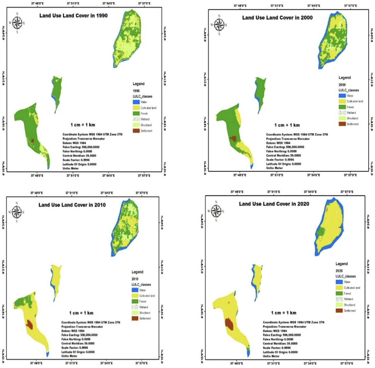
The analysis of the LULC change in the study area from 1990-2020 also confirms the above findings. For example, the cultivated land expanded from 616 km2 (16%) in 1990 to 2,886 km2 (74.2%) in 2020, and settlement increased from 14 km2 (0.3%) in 1990 to 144 km2 (3.7%) in 2020 (see Table 2). As can be inferred from Table 2, the growth in cultivated land and settlement is at the expense of forests and shrublands. Consequently, the forest area decreased from 2,335 km2 (60%) in 1990 to 145 km2 (3.7%) in 2020. Similarly, shrublands decreased from 719 km2 (18.5%) in 1990 to 12 km2 (0.3%). This loss in vegetation cover exposed the Gidicho island and its environs to devastating floods, water soil erosion, and water bodies increased by almost 14% in the last three decades, and this submerged a considerable number of farmlands every year. In this regard, a report from the Woreda environmental protection office indicates that in 2019-20 the lake submerged 110.5 hectares of cropland and banana plantations.
An analysis of ethnographic and LULC change data for the study area from 1990 to 2020 revealed that human activities are the main factor responsible for the current environmental changes in the study area, including overgrazing and deforestation for agricultural land, construction materials, and firewood and charcoal collection. This means that the results confirm the proposition that environmental change in the study area is the result of multiple factors, but the leading one is human activity. This finding is also consistent with the notions of Moran (2010), who postulated that human activities, i.e., individual or collective actions taken to meet needs are the primary cause of environmental change. Congruently, studies conducted in the Pacific Islands by Wairiu (2017), Solomon Islands by Pollard et al. (2021), Asia Pacific Islands by Katovai et al (2015), and in the Ethiopian Rift Valley Lake Islands (Zeway) by Biruk (2017) found that human activities such as selective logging, deforestation, charcoal production, and land reclamation have degraded islands’ environment. A similar study by Birhanu & Gutema (2017) reported that due to critical resource degradation in Zeway Islands inhabitants are forced to flee their homelands. Likewise, the arguments of the PE and CE theories associate resource degradation with human actions to meet their subsistence. Even so, it is difficult to conclude that all human activities trigger damage to the environment since in some other communities, such as the Konso of southern Ethiopia, human actions have contributed largely to the conservation and development of natural resources (Amazaye, 2010).
Natural Hazards (daano)
Another important factor identified was natural hazards. According to some of our key informants, natural hazards such as droughts and floods have exacerbated environmental degradation in the study area and have significantly threatened their livelihoods and way of life. Findings highlight that throughout their history the Bayso people have experienced three major droughts in 1984-85, 1998-89, and 2001-02. Of these, the drought incident of 1984-85 was unique in its extent and was a countrywide problem. Because of this drought, the Bayso has lost a large number of cattle; hunger has prevailed in the region following the dry-up of crops and the decline of animal products. However, the study reveals that the Bayso were able to mitigate the impact of such natural hazards through local mechanisms. For instance, an elder from the village of Mulato noted that their IBS had experts who could predict the weather by interpreting environmental features, which helped them to take precautionary measures. Consider the following excerpt.
Our ritual system had experts who forecasted weather conditions by deciphering environmental features. For instance, they used to recognize the onset of drought [banqe] as pastures dried up, when Mayala, a popular plant among the Bayso, turned green in hot and dry weather, and when the fog began to appear in the sky [eyotte saare]. Upon seeing such signs, they advised Wonnos and the community to take adaptive measures [e.g., gondossa], a periodical move with herds to areas of better pasture. Nonetheless, following our conversion to Christianity such local mechanisms used to lessen the impact of natural hazards were ignored and this aggravated the problem of environmental change (Abate Lageru, September 25, 2020).
Parallel to this, a study by Vern et al. (2019) posited that island systems are among the most vulnerable to changes in the frequency and intensity of extreme weather events (e.g., droughts, storm surges, hurricanes) as well as altered patterns of seasonal and mid-term weather systems. According to Osmar (2019), extreme weather events viz. drought and floods significantly affected the socio-economic life of inhabitants in Zanzibar Island.
Likewise, the loss of vegetation cover in the Gamo highlands has been the primary cause of flood (daad) in the study area. The flash flood descends from these areas to villages at the foothills and then to the lake. This resulted in an increase in the lake water level due to silt accumulation, which in turn submerged villages and fertile agricultural lands of the Bayso, essentially on the west coast of the lake. As in other flood-prone areas of the country, floods usually affect the study area at the peak of the rainy season (July and August) badeessa. However, there are also flash floods that cause substantial damage to the environment and people’s livelihoods in Alge village.
The following excerpt depicts how floods have become a major environmental problem in the study area.
Owing to the decline in vegetation in the Gamo Highlands and the ensuing damage caused by floods, we lost our farmlands, crops, villages, school buildings, and a clinic built with foreign aid. Beyond such economic destruction, the heavy floods ruined the social fabric of our community, forcing us twice to change our villages and resettle in other areas. Besides, the rising lake water level due to silty accumulation has submerged burial and ritual sites along the lake’s coast (German Lamisa, Alge village, November 12, 2021).
This excerpt is consistent with the findings of Fawwaz, Aldardasawi, and Eren (2021), who stated that floods affect inhabitants’ livelihoods, causing over-saturation, infertility, soil erosion, and damaging crop fields. As a result, we argue that this finding shows not only the challenges that flash and seasonal floods pose to people’s lives and livelihoods but also the interconnection between factors for environmental change. For instance, deforestation and the ensuing loss of vegetation cover in the Gamo highlands led to flooding, which in turn affected the natural quality of the environment along the shores of Lake Abaya.
Structural factors
The findings also revealed that structural factors such as population growth, villagization, poverty, and investment activities contributed to the degradation of natural resources in the study area. Documents have shown that the population of the Bayso was approximately 3,260 in 1994 Brenzinger (1995), 5,491 in 2007 CSA (2007), and the current projection is 9,800 (Joshua Project, 2023). This implies that in the last 30 years, the population of the Bayso has tripled. It is also assumed similar growth in coastal areas given such local population growth, expansion of investment activities, and the villagization scheme. Therefore, it can be presumed that the growing population in the region has put pressure on the environment, as people require more land for agriculture and forest products for construction and energy. Moreover, as the majority of newcomers had no other means to sustain their lives until they collected their first harvest, they engaged in tree cutting to sell logs, firewood, and charcoal, which intensified the damage to the vegetation cover. This is comparable to the findings of Bielli et al. (2001), who reported that the population in Ethiopia, which is growing at a startling rate of approximately three percent per annum, has been clearing forests at an alarming rate to meet its increasing need for food, fiber, and energy. In this regard, while we do not deny the impact of population growth on the environment, we also cannot argue that it is a curse.
The reason is that if these communities have other ways to meet their needs, they would not harm their environment since they believe that they are inextricably linked to it mentally and physically. For example, according to Gessesse & Christianson (2008) in the Machakos district of Kenya, although the population of Machakos is five times larger than it was in the 1930s, recently, the environment and agricultural production of the district has improved, contrary to the view that population growth has led to the degradation of forests and a decline in production.
The study also identified poverty as an influential factor. The Bayso characterized poverty in terms of two long-established modes of subsistence: pastoralism and agriculture. In their pastoral lifestyle, wealth was measured by the number of herds an individual owned, whereas now, as a farming community, they associate wealth with owning large, fertile tracts of land. Consider the following extract:
In our tradition, individuals who had few milking cows and goats were considered poor, as such individuals would have no extra milk or butter left over from consumption to sell on the market to support their meager economy. However, nowadays we have changed our mainstay to agriculture, and the measure of wealth is the amount of fertile land, mainly with a banana plantation that a person owns. The problem is that we have been losing much of our fertile lands due to the rising water level of the lake in coastal areas. Therefore, the growing poverty forced us to sell logs and firewood and burn charcoal for the market, disregarding taboos and sanctions (Geremaw Darge, Gidicho, November 17, 2020).
Currently, increasingly, scholars see poverty as a critical component of environmental change. For example, Shaista (2010), Kirui (2016), and Malerba (2020) argue that the fact that the impoverished depend on natural resources for their survival means that any degradation of these resources directly worsens their living conditions.
This cycle of poverty and environmental degradation creates a feedback loop in which the struggle to meet basic needs further increases pressure on the environment, leading to greater resource depletion and ecosystem degradation. Conversely, we argue that if these destitute have other means of survival or if government officials play their role in creating opportunities for them, they may not engage in such damaging activities because they realize the value of their environment to their lives. Besides, as people’s perceptions and values of their environment are not static and change over time due to factors discussed in this study, rural communities such as the Bayso are not immune to such changes. Therefore, forced by the growing poverty in their locality they engaged in activities that exacerbated environmental degradation as highlighted in the above excerpt.
On the other hand, the Derg regime (the military government that ruled Ethiopia from 1974 to 1991), cognizant of the severe environmental degradation and the resulting resource scarcity on Gidicho Island that has affected the Bayso’s livelihood, had introduced a villagization program in areas on the western shore of Lake Abaya since 1984-85 to save the lives of inhabitants. However, the Bayso are critical of this initiative, claiming that it never takes into account the sociocultural and ecological differences at the grassroots level. In a related case, a local official in Alge village stated that:
At that time [in the 1984-85 drought], we were indeed suffering from severe resource degradation caused by a drastic drought and the resultant death of our cattle, which were the backbone of our livelihood and ritual system. We therefore needed socio-economic support to sustain ourselves as a community. However, we objected to the villagization program for the following reasons. First, we were not prepared to leave our cultural base forever, and some of us were even determined to die there. Second, the local officials were using grazing lands for the villagization program on the assumption that it was vacant land, hence, aggravated the scarcity of grazing land. Third, the demand for arable land, construction materials, and energy supplies required us to clear forests and scrubland, exacerbating the damage to natural resources. As a result, the delicate balance of the ecosystem was disrupted, leading to soil degradation and loss of biodiversity. Lastly, our inclusion in a village with dominant cultural groups, such as the Gamo, threatened our cultural life by exposing us to Protestant Christianity, which affected our cultural traditions, including local mechanisms of environmental conservation (Kalsa Yasuma, Alge village, December 11, 2020).
Parallel to the above excerpt, Lewis (2008) posited that structural factors such as government policies and decisions aimed at socio-economic development contribute to natural resource degradation. For instance, according to Mekonen et al. (2020), while Ethiopia’s villagization program has improved access to social services and diversified income sources, it has also perpetuated past resource shortage issues, posing new risks and vulnerabilities. Equally, Tadesse (1995), in his study of the Guji-Ormo reported that the villagization scheme has caused the greatest damage to the environment and inhabitants’ lives.
The study also revealed that investment activities in the study area have no less impact on the environment. The findings revealed that the first investment project in Mirab Abaya was registered in 1976-77 during the Derg era. At the time of this study, there were nine investment projects in horticulture and banana plantations. To date, the regional investment office has transferred 2,000 hectares of forest and shrublands for these projects. Findings reveal that investment activities in the study area are responsible for the degradation of forests and shrublands owing to investors’ encroachment on nearby forests and buffer zones to cultivate additional land. Chemicals used to control pests and weeds infiltrated lake water and severely affected the fish resources of the lake. The LULC change analysis in the study area also corroborates the ethnographic account, highlighting the loss of 2,886 km² of forest and 145 km² of shrublands, at the expense of essentially expanding cultivated land and settlements. In addition, investors in the study area were reluctant to carry out environmental impact assessments, and/or those who made such assessments were not willing to implement their projects as per the recommendations of such studies. This implies that investors in the study area are operating against the very spirit of investment policy article 54.2, which argues that “All investors shall give due regard to social and environmental sustainability values including environmental protection standards and social inclusion objectives in carrying out their investment projects” (FDRE, 2020, p. 12,423). In general, the findings on structural factors are consistent with the notion of PE, which asks whether government policies and decisions that do not take into account local circumstances are detrimental to the environment and the quality of life of local communities. This implies how government initiatives to address one problem in Ethiopia can exacerbate another by failing to recognize socio-economic, cultural, and environmental diversity at the grassroots level. The findings also highlight how structural factors exacerbate environmental degradation in the study area by influencing the resource use behavior of the study community in the absence of alternative livelihoods.
Trends in Environmental Change
As highlighted in the preceding pages, the study area has lost a significant amount of its vegetation cover, mainly because of the expansion of cultivated land in the last three decades (see Table 2). The analysis of the LULC changes from 1990 to 2020 asserts that the study area has experienced a loss of 2,190 km2 (56.3%) of the total forest land and 707 km2 (18.2%) of scrublands (see Figure 1 and Table 2). As a result, the thick acacia forest and rich grassland along the western shore of Lake Abaya documented in the reports of Petros (2019), Asheber et al. (2018), and Seid & Hatuye (2019) are no longer present. The trend of change in cultivated land in the study area has shown a steady increase in an almost exponential manner, which can be correlated with the loss of almost equal amounts of forests and shrublands (see Table 2 and Figure 2).

.png)
However, the trend shows periodic fluctuations in some LULC change classes, mainly in shrublands. For example, the study area experienced a significant decrease in forest and shrublands from 1990-2000, which was due mainly to the expansion of cultivated land by the local community and investors. The need to meet the energy and construction material of a growing population also contributed. It is also believed that the growing poverty in the region has forced people to rely on forest products for their survival, as there are no alternatives to sustain their livelihoods.
From 2000-2010 the study area lost a vast amount of forestland, whereas shrublands increased significantly from 263 km2 (7%) in 2,000 to 372 km2 (9.6%) in 2010 (see Tables 2). We believe that such an unusual increase in scrubland is due to some investors who, for various reasons, have quit their investment in agriculture. Equally, the investment commission has the right to revoke investment licenses for the violation of contracts. As a result, such farmlands have become overgrown with shrubs over time. Once again, since the beginning of 2010, shrublands have declined to 145 km2 (3.7%) in 2020; conceivably, such lands are transferred to other investors and peasants who lost their farmlands due to the invasion of lake water. During this period, damage to forest resources seemed to have decreased, perhaps due to a slowdown in the expansion of cultivated land and/or the enforcement of environmental protection laws.
Conclusion
This study examines the critical factors that have led to severe environmental changes on Gidicho Island and in coastal areas of Abaya Lake and highlights the adverse impacts these changes have had on the community’s livelihoods. Understanding these dynamics is essential to address the challenges faced by the inhabitants and to find a path toward sustainable solutions. The Bayso people, who live on Gidicho Island and in villages around the lake, have suffered greatly from drastic environmental changes that have threatened their livestock, the mainstay of their livelihood and ritual system. The study revealed that human activities, including clearing forests and scrubland for agricultural land, as well as for construction materials and energy supply, are the drivers of environmental change in the study area. However, the resource-use behavior of the Bayso is shaped by sociocultural traditions that necessitated maintaining large herds to satisfy the demand for animal products, such as meat, milk, blood, and content of animal stomachs, for their numerous religious rituals, in addition to their subsistence needs. The study also considers the effects of natural hazards, like droughts and floods, and structural factors, including population growth, poverty, villagization, and investment activities. This means that environmental change in the study area is a function of multiple factors, but the leading one is human activity. It is also crucial to note that environmental degradation in the study area has caused severe resource scarcity, soil infertility, siltation, and flooding of farmlands, all of which have disrupted the livelihoods and cultural life of the Bayso, including local mechanisms of environmental conservation. Accordingly, we suggest that awareness creation and training in sustainable resource management could enable the Bayso people to develop a sense of responsibility and adapt to environmental change while maintaining their cultural heritage. Similarly, involving the Bayso in participatory conservation programs (e.g., reforestation, afforestation, and terracing) could empower them to take an active role in preserving their environment. Equally, establishing a community-led committee to monitor natural resource management and integrating traditional ecological knowledge into conservation strategies would ensure that solutions are culturally relevant and sustainable.
Competing interest
The authors have no competing interests to declare that are relevant to the content of this article.
Availability of Data
Since this paper emerged from a PhD Dissertation, data is available only by communicating with the corresponding author.
Ethical approval and consent to participate
In this regard, firstly, we produced a letter of support from Addis Ababa University and presented this letter to officials at Zonal and Woreda and this eased our communication with concerned bodies during our field stay. Secondly, we informed all concerned bodies, both officials and the layman about the research objective and participation is fully on informed consent, which means they have the right to quit at any time if they feel discomfort. Finally, where needed, we have used fictive names in the text to protect informants from possible threats.
Funding details
This study was financed by Addis Ababa and Arbaminch Universities.
Author’s participation
- Eshetu Fekadu: participated in data collection, organization, analysis, and writing the draft.
- Dr. Mamo Hebo supervised the fieldwork and reviewed the subject matter and theoretical aspects of the study.
- Dr Guday Emirie also supervised the fieldwork, engaged in technical support, and edited the language of the manuscript.
Acknowledgment
We would like to extend our heartfelt thanks to our informants and research assistants for their unreserved effort, willingness, and commitment to facilitating our fieldwork at the expense of their precious time and energy. We also owe Ato Abera Asele for his dedication and expertise in downloading and organizing the GIS data for this study. We are also grateful to Addis Ababa and Arbaminch Universities for financing the dissertation project out of which this article emerged.