

1. INTRODUCTION
The first advancements in climate change policies in Ibero-America were made with the creation of the Ibero-American Network of Climate Change Offices (Red Iberoamericana de Oficinas de Cambio Climático – RIOCC) in 2004 (Martín Murillo et al., 2018). The increasing concern over the impacts of this phenomenon has accelerated the development of regulations and instruments for mitigation and adaptation, particularly since 2015 (Pörtner et al., 2022). As a result, ten countries in the region currently have specific climate change laws, including Chile’s recent Framework Law 21.455 for Climate Change, which was approved in 2022 (Moraga Sariego, 2022).
Although Chile only contributes 0.25% of the world’s greenhouse gas (GHG) emissions (GC, 2021), climate change impacts have manifested themselves in its territory in recent decades. Global warming has been evident in all Chilean regions, with temperatures consistently above average since 2011 (MMA, 2020). Precipitation has decreased, particularly in the central and southern parts of the country. This trend, coupled with temperature increases, has led to an increase in heatwaves and forest fires (Hernández & Madeira, 2022). Additionally, rising sea levels and more frequent and intense extreme weather events have had significant consequences, particularly in coastal areas (Madariaga Gómez de Cuenca, 2021).
The spatial variability of climate change effects necessitates the implementation of scientific studies and policies at a regional or local level, a requirement that does not align with the neoliberal centralist system on which the Chilean state and its Constitution are based (Madariaga Gómez de Cuenca, 2021). This situation has resulted in the overexploitation of natural resources by large companies, many of which are foreign, primarily in the mining, forestry, and aquaculture sectors. The perpetuation of an unsustainable production model has led to successive socio-environmental crises in the 21st century and these culminated in the social unrest of October 2019. In response to the demands expressed during this collective movement, measures to combat climate change began to be strengthened within institutional, legal, and even constitutional frameworks (Pizarro Hofer, 2020; Sapiains et al., 2022).
In the research described here, the Chiloé archipelago, located in Chilean Patagonia, was selected as the study area. Like other island environments, Chiloé is one of the locations in Chile that is most vulnerable to the effects of climate change due to its low altitude and scarcity of resources such as freshwater (Gajardo et al., 2017; Masson-Delmotte et al., 2021). Consequently, the interconnection between island lifestyles and the environment has facilitated an understanding of the reality of climate change, particularly in coastal communities, where climate-related natural hazards are more frequent (Delgado, Zúñiga, et al., 2021). The World Wildlife Fund (WWF) recognized the cultural and ecological uniqueness of Chiloé and has designated this region as one of the 25 priority areas for ecosystem conservation worldwide (Barrena, Nahuelhual, et al., 2014). This region also meets six out of the nine vulnerability criteria for climate change outlined by the United Nations Framework Convention on Climate Change (UNFCCC), i.e., low-lying coastal areas, forested areas exposed to environmental degradation, regions prone to natural disasters, areas susceptible to drought and desertification, cities with air pollution, and insularity (Pachauri, et al., 2014).
In an effort to address this information gap, the primary objective of the work described here is to examine the implications of climate change in the Chiloé archipelago. The secondary objectives are as follows: (a) to identify vulnerable coastal areas affected by climate change, and (b) to understand interactions between coastal-marine problems in Chiloé and climate change.
2. METHODOLOGY
2.1. Identification of Low Elevation Coastal Zones
Chile’s location southeast of the Ring of Fire of the Pacific plate makes it one of the most seismically active countries globally. The high frequency of seismic events makes it challenging to project mean sea level rises in Chile due to the significant uncertainty associated with the results. Furthermore, mean sea level measurements prior to 1999 were not found in tide gauges located in Chiloé. Therefore, the methodology of McGranahan et al. (2007) was employed to identify coastal areas that are vulnerable to intensified adverse weather events and mean sea level rises in Chiloé. This approach involved identifying Low Elevation Coastal Zones (LECZ), which are defined as coastal areas that are less than 10 meters above the mean sea level.
On a global scale, LECZ represent only 2% of the Earth’s surface, but this narrow strip of territory is inhabited by 10% of the world’s population. For example, in Chile, approximately 1 million people live in the LEZC (Igualt et al., 2025), according to the definition of McGranahan et al. (2007). However, the simulations of mean sea level rise do not reach the threshold of 10 meters in any case. Therefore, with the application of this methodological proposal and its resulting mapping, a much larger space is covered, which could be used to devise adaptation measures applied not only to variations in mean sea level, but also to other implications of the current climate situation, such as the increasing frequency and intensity of adverse meteorological events arising from the sea.
The delimitation of the LECZ of McGranahan et al. (2007) is based on an arbitrary metric criterion that is not adapted to the particularities of each territory. For this reason, and considering the intrinsic vulnerability of island environments to climate change, in addition to the multiplicity of natural hazards and coastal conflicts, this study redefines the concept of LECZ to better fit the geography and operational problems occurring in Chiloé. Thus, the methodology was implemented using a functional criterion based on the location of areas that could be affected by the occurrence of a large tsunami.
The space resulting from the use of this indicator could have two purposes: on the one hand, from the perspective of methodological rigor, it is more reasonable to use a functional criterion rather than an arbitrary one, especially when it is applied in a specific environment; on the other hand, in the context of land-use management, it is more convenient to have a single instrument for the simultaneous management of risks, either linked to climate change or not. Numerous studies have been reported in which multi-risk assessments are carried out based not only on the effects of climate change, but also on pre-existing problems, such as flood recurrence or even tsunami run-up. For example, Hereher et al. (2020) and Sood et al. (2025) studied the impacts of mean sea level rise and tsunamis together using Geographic Information Systems (GIS).
In Maullín, a commune located just north of the Chacao Channel, Lagos (2012) determined the tsunami risk by considering the maximum altitude reached by the run-up caused by the 1960 Chilean earthquake of magnitude 9.5 MW (the most powerful earthquake in human history) and the tidal range in a syzygy situation. Application of this formula resulted in a maximum tsunami inundation height of 9.55 m, a threshold that was not exceeded by the 2010 tsunami. In addition, the inundation charts provided by the Hydrographic and Oceanographic Service of the Chilean Navy (Servicio Hidrográfico y Oceanográfico de la Armada de Chile – SHOA) for the coasts of Chiloé do not indicate any vulnerable locations exceeding 10 m above mean sea level (SHOA, 2022).
However, other locations along the Chilean coast have experienced maximum run-ups that exceed the threshold estimated for the Maullín commune. Historical records in the region indicate four instances of tsunamis with run-ups that exceeded 10 m in different parts of the country: in 1562 (16 m), 1730 (16 m), 1835 (15 m), and 1960 (15 m) (Martínez et al., 2011). In this research the worst-case scenario was considered to account for the most severe impacts that could occur in Chiloé. Therefore, the LECZ have been identified as areas located below the 16 m isohypse, which is the highest value reached by tsunami run-ups in Chile. The use of the most catastrophic scenario provides a better adaptation to all risks and in a longer time frame in the context of climate change. The application of this functional criterion results in a much larger vulnerable space that not only adjusts to the consequences of climate change but also serves to assess the risk to possible future tsunamis.
The estimation of LECZ in Chiloé was implemented through ArcMap software using the Digital Elevation Model (DEM) of the Spatial Data Infrastructure (SDI) provided by the Chilean Ministry of National Assets. The resulting 4 m resolution cartographic information layer was combined with land use data to identify the sectors that are most vulnerable to the effects of climate change and to improve the quality of representation. This means that land uses located within the coastal territory below 16 m above mean sea level were extracted and studied. Once the mapping was completed, the area occupied by each use within the LECZ was calculated and transferred to an Excel file to facilitate the comparison of the results.
Additionally, several point and linear elements of critical interest were located within the LECZ by compiling cartographic sources. These were structured into four categories: elements of economic interest, elements of tourist-cultural interest, facilities, and infrastructure. This procedure was performed by downloading the existing information layers available in the SDI. Furthermore, Google Earth was employed to digitize spatial layers not included in this repository, as well as to enhance and update available information. All of the above was complemented by on-site knowledge acquired during several field trips conducted between June 2022 and February 2023. Finally, different subcategories were set up and quantified according to the topology of the cartographic layer. In this way, two indicators were included: the number of entities located within the same point or polygonal information layer and the length of the linear layers within the LECZ.
2.2. Interaction between coastal-marine problems and climate change
Climate change not only serves as a driver for new pressures on the territory but also exacerbates pre-existing coastal-marine problems (Vázquez Pinillos, Chica Ruiz, et al., 2023). To structure the territorial imbalances faced by Chiloé, a table was developed to classify them following the categorization of Sapiains et al. (2019). This study argues that the population of the archipelago is mainly concerned with four problems that have a direct or indirect relationship with climate change: pollution caused by the aquaculture industry, water stress, the expansion of forest monocultures, and the overexploitation of natural resources. In addition, we added a fifth classification along with other weaknesses of Chiloé that may be intensified by climate change.
The publications were obtained from the Scopus database using different searches. We first located all publications prior to the year 2000 that contained the word “Chiloé” in their title, abstract and/or keywords. To find references on the categories into which we divided the table, four independent queries were made in which a second term was added. The following queries were run: “Chiloé” AND “aquaculture,” “Chiloé” AND “water,” “Chiloé” AND “forestry,” and “Chiloé” AND “exploitation.” For other issues associated with climate change, a general search was conducted for papers containing the term “Chiloé.” After each query, the references were purged to focus only on those addressing land conflicts in Chiloé. In cases where further bibliographic support was needed, new searches were carried out using Google Scholar based on the same parameters mentioned above.
The table includes a second column with subcategories that facilitate the analysis of territorial problems. Each of these specific conflicts is accompanied by bibliographic references from which the information has been extracted. This procedure also makes it possible to deduce the degree of confidence of each attribute in the table: the greater the number of references dealing with the same subject, the greater the reliability of the result. Finally, a column was incorporated to connect Chiloé’s socio-ecological conflicts with climate change.
3. Study area
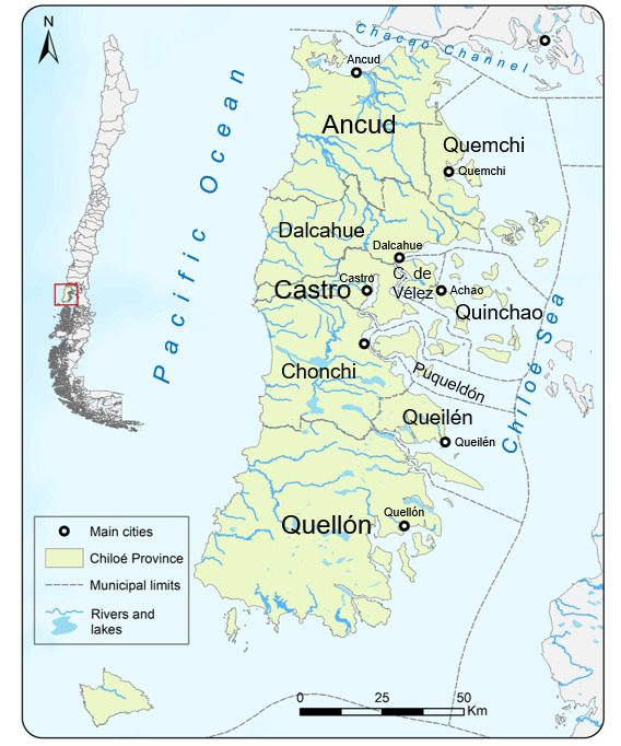
Chiloé is one of the four provinces of the Los Lagos Region and it is situated between 41º and 43º South latitude (Fig. 1). Chiloé is an archipelagic environment that covers 9,182 km2 and encompasses more than 40 islands, including Isla Grande de Chiloé, the second-largest island in South America. The province of Chiloé has a population of 168,185 according to the most recent census and it is divided into ten communes, with Castro (the capital) and Ancud being the two most significant in terms of demographics and economy (INE, 2017).
The isolated nature of Chiloé contributes to its strong cultural heritage and unique geographical features, which differentiate its landscapes, traditions, customs, architecture, and gastronomy from the rest of the country (Barrena, Nahuelhual, et al., 2014). In Chiloé, tradition and modernity coexist, with the latter being introduced to the archipelago through the establishment of the salmon farming industry in the 1970s and 1980s (Delgado, Zúñiga, et al., 2021). This industry has given rise to significant socio-ecological conflicts in Chiloé, reaching a peak with the Harmful Algal Bloom (HAB) event in 2016. Nevertheless, 29% of global salmon production currently comes from southern Chile, thus making it the second-largest salmon producer in the world (Iizuka & Zanlungo, 2016).
The geographical location and positioning of Chiloé result in a rainy maritime climate that is characterized by abundant rainfall and moderate temperatures. However, these variables are undergoing a transformation similar to the changes observed on a national scale. Based on data available from the Mocopulli weather station, maximum temperatures in the archipelago have increased by 0.1 ºC per decade since 1961. The influence of climate change is most evident in the declining trend of precipitation in Chiloé, with a reduction by more than 5 mm per year, which is especially striking in summer (DMC, 2025).
4. RESULTS
4.1. Identification of Low Elevation Coastal Zones
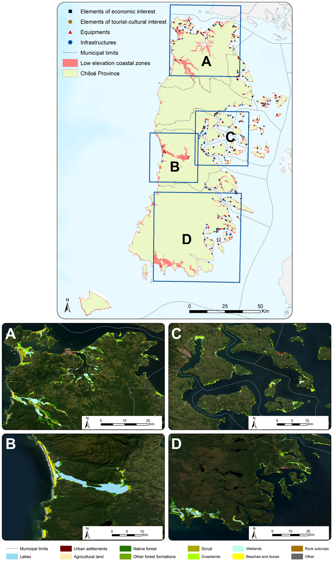
Given the presence of the Coastal Range spanning from the northern to the southern regions of Chile, the extent of the LECZs is not significant. However, this scenario differs in the study area because Chiloé is an island environment where the highest relief does not exceed 1000 m in altitude. Fig. 2 establishes the LECZ, in addition to the elements of socioeconomic interest and the uses that occur in this space located below the 16 m of altitude. To observe the different results obtained along the coastline of the province of Chiloé more clearly, four spatial markers were included in the cartography.

On the western coast, due to the abrupt orography of the Cordillera de la Costa, the LECZ are delimited by cliffs, except in the estuaries of rivers and lake basins of the central zone. The rugged relief and hostile climate have historically been an impediment to the settlement and economic development of the Pacific Coast in Chiloé; hence, there are hardly any significant features located below the threshold of 16 m of mean sea level. In contrast, the sheltered and less abrupt coasts of the Bay of Ancud, north of the study area, and the inland sea of Chiloé present a greater economic and demographic dynamism, which explains the higher density of critical points on the map.
It can be observed that 4.92% of the total area of the province of Chiloé lies below 16 m above mean sea level. As one would expect, the most vulnerable ecosystems to climate change in the province are those that are naturally situated along the coastline, including beaches, dunes, marshes, and rocky outcrops. Additionally, almost a quarter of the archipelago’s urban fabric is concentrated in this area, thus indicating that a significant proportion of the population resides in coastal areas that are susceptible to the coastal impacts of climate change and potential tsunamis. Notably, the most densely populated cities such as Castro, Ancud, and Quellón are situated in coastal regions with relatively low elevations. The low altitude of the settlements is even more prominent in cities such as Quemchi, Achao, or Queilén, where most of the buildings, infrastructure, and services are located below 16 m above mean sea level. In summary, the population residing in rural districts and urban census blocks affected by the LECZs exceeds 45% of the total population of the province of Chiloé (Fig. 3).

Furthermore, 665 specific elements of significant socio-economic value have been identified and classified into four categories: elements of economic interest, elements of tourist-cultural interest, facilities, and infrastructure (Table 1). Aquaculture concessions have also been included within the first category as they constitute a vital component of the production model in Chiloé. Although aquaculture primarily occurs at sea rather than within the LECZ, its coastal location renders it vulnerable to the impacts of climate change. The issues concerning the fisheries and aquaculture sector and its connection to climate change are addressed in a dedicated section below.
It can be seen from Table 1 that tourism is one of the sectors that is most vulnerable to adverse meteorological events along the coast. The archipelago’s main attractions include its coastal landscapes and stilt houses, which are already experiencing the effects of climate change due to their proximity to the LECZ. Another noteworthy cultural aspect is the group of 16 churches, which were declared UNESCO World Heritage Sites in 2000 and represent the Chiloé School of Religious Architecture. Given that these churches are situated in populated coastal areas, it is not surprising that 69 of them, including 9 listed by UNESCO, are located within the LECZ.
Regarding infrastructure, a concerning factor is the presence of 48 healthcare facilities situated less than 16 m above mean sea level, including the hospitals in Achao and Queilén. Lastly, the infrastructure category also encompasses the extensive road network within the LECZ. It is estimated that approximately 592 km of roads and highways could be affected by the coastal implications of climate change. Such impacts could lead to connectivity and displacement issues during emergencies.
4.2. Water stress in Chiloé
The direct impacts of climate change, such as increasing temperatures, intensification of extreme weather phenomena, mean sea level rise and fluctuations in rainfall patterns, have been extensively studied and quantified. For instance, the Chilean Meteorological Directorate has a database that records the evolution of these variables over time (DMC, 2025). However, the connections between these trends and regional-scale territorial pressures (pollution, changes in use, overexploitation, etc.) have not been explored sufficiently. The fusion of climate change threats and socio-ecological problems arising from the current development model generates complex risks that are often overlooked by political-administrative instruments (Abdillah et al., 2025; Lin et al., 2025).
Due to the scarcity of freshwater reserves, water availability in Chiloé is highly dependent on annual rainfall. The island’s insularity and proximity to the sea prevent the formation of long rivers and large freshwater lakes. Furthermore, unlike most of Chile, Chiloé lacks steep elevations, making glacier formation impossible (Delgado, de Ríos, et al., 2021). The decrease in annual rainfall caused by climate change exacerbates the water stress and this, in turn, affects an increasing number of people in the province each year. In fact, the scarcity of water in summer is currently considered to be the second most alarming socio-ecological problem in Chiloé, surpassed only by environmental conflicts arising from salmon farming (Sapiains et al., 2019).
Currently, the water in rural areas of Chiloé is still supplied by traditional sources, such as wells or artisanal rainwater harvesting methods, especially during months with higher rainfall. In summer, the water supply of well-connected rural populations depends on Water Committees associated with the Rural Drinking Water Program (Programa de Agua Potable Rural – APR). These are independent local organizations that manage water for domestic and agricultural use (Ther Ríos et al., 2018). Although APRs constitute an adequate system for water resource management in small localities, they lack sufficient support from public administration. According to Delgado et al. (2021) and Frêne et al. (2022), a more integrated water governance model is needed, where there is better coordination between the different APRs, as well as between these and public institutions, in order to propose participatory mechanisms to adapt to current challenges, such as those arising from climate change.
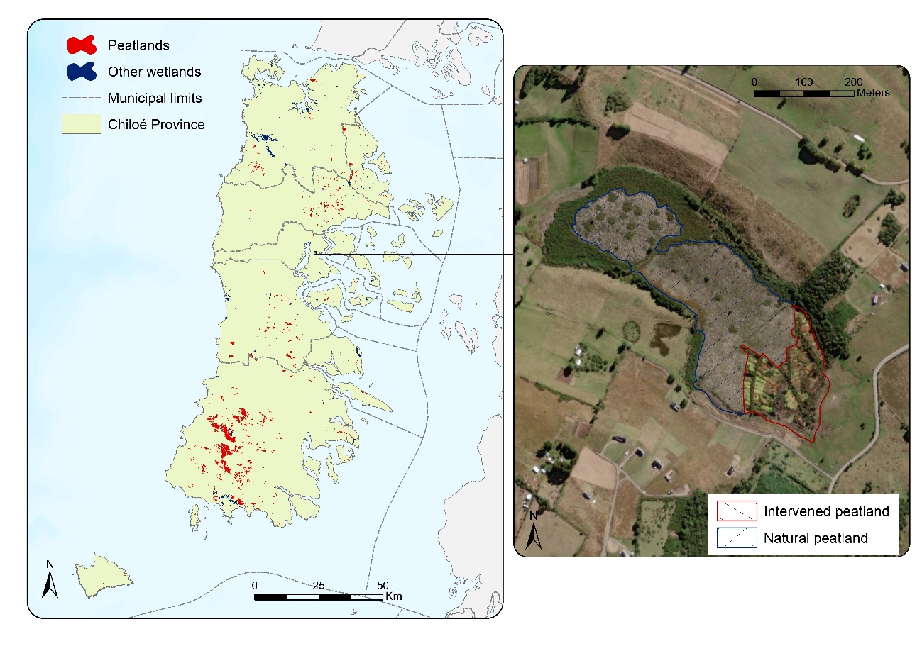
In Chiloé, peatlands serve as the primary reservoir of freshwater in the region due to their ability to absorb and retain significant amounts of water. These wetlands formed in poorly drained areas as a result of deglaciation approximately 13,000 years ago. They are ancient ecosystems composed of a thick layer of semi-decomposed organic matter, a byproduct of constant waterlogging, substrate acidity, and anaerobic degradation (M. F. Díaz et al., 2015). Out of the 909 peatlands in the study area, 96.5% of them are covered by Sphagnum moss, which can hold up to 20 times its dry weight in water (León & Benítez Mora, 2022). These wetlands primarily rely on water from river currents and rainfall. During winter, the excess water received by the peatlands is discharged through surface runoff, while in summer, when rainfall decreases and water stress intensifies, the water table drops to the lower layers of the peat, thus protecting the water from evaporation (Zegers et al., 2006).
In addition to their role in water regulation in the archipelago, peatlands act as the main carbon sink on the Earth’s surface, thus making them a potential resource for the mitigation of climate change. These ecosystems, which occupy only 3% of the Earth’s land area, contribute to 30% of carbon fixation and 10% of the planet’s freshwater (León & Oliván, 2014). Unfortunately, peatlands in Chiloé are currently undergoing degradation processes driven by both natural causes related to climate change and anthropogenic factors. On the one hand, the preservation of the ecological integrity of these ecosystems relies on low temperatures and abundant rainfall. Given the observed climate trends in the region, it can be inferred that climate change is detrimental to peatlands. On the other hand, since the beginning of the 21st century there has been an increase in peat exploitation driven by rising demand from countries such as Taiwan, Japan, the USA, and China, where peat is used as a substrate for vegetable and flower cultivation (Cabezas et al., 2015).
The removal of the compact layer of moss exposes the peat to the action of wind and this accelerates the oxidation and subsequent decomposition of organic matter. As a result, peatlands lose their climate regulation capacity and become sources of GHG emissions (Broder et al., 2012). Furthermore, canalization projects conducted by farmers and forestry companies exacerbate the problem and reduce the availability of freshwater for the population during summer. Consequently, peatland exploitation is considered to be an extremely harmful activity in Chiloé, particularly considering the low resilience of these ecosystems and their potential in combating the root causes of climate change. The territorial implications of moss extraction in a peatland located in the commune of Castro are illustrated in Fig. 4.

From a legal standpoint, peat is classified as a mineral resource according to the Mining Code and its exploitation is therefore the responsibility of mining companies. Furthermore, under Law 18.091 of 1982, the rights of concession holders take precedence over the interests of landowners where peat bogs are located. As a result, only peatlands within settlement boundaries are protected under Law 21.202, which safeguards urban wetlands. Despite their ecological, cultural, and landscape value, new mining exploitation and exploration concessions continue to encroach upon Chiloé’s primary water reservoir each year (Gajardo et al., 2017). Meanwhile, the freshwater supply on the island increasingly relies on water trucks that arrive by ferry from the mainland (Ther Ríos et al., 2018).
4.3. Territorial conflicts in the inland sea
Artisanal fishermen represent one of the sectors that is most impacted by the consequences of climate change. The acidification of waters, changes in sea salinity and temperature, and the intensification of adverse weather events are leading to the displacement of certain commercial species towards higher latitudes and depths. In contrast, sessile organisms, which lack the ability to move, adapt to rising temperatures by increasing their energy consumption to construct their external skeletons (León et al., 2018). This issue is particularly critical considering that corals, crustaceans, and bivalves serve as the foundation of artisanal fishing and Chiloé’s culinary tradition.
In the study area, the LECZ house 91 fishermen’s coves located in areas vulnerable to storms, tidal waves, and rising sea levels. Pica et al. (2019) observed an increase in the frequency of port closures in Chile due to inclement weather, resulting in a reduction in fishermen’s income. Additionally, the weakening of winds from the Pacific anticyclone and the intensification of the El Niño phenomenon have led to a decline in phytoplankton levels (Delgado, Zúñiga, et al., 2021; Soto Oyarzún, 2019).
However, the decline in fishing activities began to be perceived with the rise of the aquaculture sector, particularly after the establishment of the salmon farming industry in the 1980s, long before the impacts of climate change became so evident. As a result, most of the jetties and industrial plants in the LECZ are now used for the processing and handling of aquaculture products. Nevertheless, the diversification of production not only led to economic conflicts. In 2007, the first sanitary crisis occurred in Chiloé and this was caused by the spread of the ISA virus in farmed salmon. Faced with the significant financial losses suffered by salmon farming companies, the state reinforced control and requirements for Environmental Impact Assessments (EIA) of proposed projects, albeit without considering climate change as a criterion (Rodríguez Luna et al., 2021).
The second environmental crisis was triggered by the same sector and occurred between February and May 2016. This crisis had an impact not only on salmon farming but also on artisanal fishermen and Chiloé society as a whole. In February 2016, a red tide induced by the microalgae Pseudochattonella verruculosa occurred, killing, in just one week, 6,163,000 salmon. The problem was compounded when the port authority gave permission to dump between 4,600 and 9,000 tons of the dead fish 75 miles off the northwest coast of Chiloé for 16 consecutive days in mid-March. Shortly thereafter and due to the course of ocean currents that transported the mass of decomposing salmon toward the inland sea, a second red tide took place, this time categorized as HAB, originated by Alexandrium catenella, a species that causes paralytic shellfish poisoning (PSP), a pathology that affects both marine organisms and humans (Bustos & Román, 2019; Mascareño et al., 2018). To reduce the risk of disease, the Chilean government ordered on March 19 a ban on all activities related to resource extraction in the southern inland sea. Subsequently, on April 18, the measure was extended to practically the entire Los Lagos Region, between 40º and 43º South latitude, along 2,000 km of coastline (Araos et al., 2019).
Regardless of the reasons behind the 2016 HAB, climate change is seen as a factor that increases the risk of such phenomena occurring. Unless the production model changes, it is likely that the observed climate trends in Chiloé will trigger new red tides in the region, especially considering that salmon require temperatures between 13 and 17 degrees Celsius to survive (De Silva & Soto, 2009). Indeed, since 2016, several cases of smaller microalgal blooms have been reported in specific areas of the inland sea (Vázquez Pinillos, Barragán Muñoz, et al., 2023). In Norway, the only country that surpasses Chile in salmon production, an increase in the frequency of HAB events in farming areas is also predicted due to climate change (Neis et al., 2023).
Among the most concerning consequences of this environmental problem are the decline in biodiversity, the occurrence of anoxic areas, beach closures, strandings, poisoning of the population through consumption of contaminated bivalves, and economic losses (Garreaud, 2018). It should be noted that salmon farming in Chiloé primarily focuses on the cultivation of Atlantic salmon, which is classified as an invasive species due to escape incidents caused by increasingly frequent storm surges and storms (Sepúlveda et al., 2013). Cortés et al. (2020) warned that the issues currently affecting Chiloé’s inland sea may extend to the rest of Patagonia, potentially even impacting the Argentinean coast, where sightings of salmon from Chilean aquaculture farms may begin to occur in the coming years.
4.4. Other coastal-marine problems
The expansion of the aquaculture industry has led to a significant portion of the rural population migrating to coastal settlements in search of better economic opportunities. This growth of urban areas along the coastline has increased the vulnerability of the archipelago’s residents to the threats of climate change and tsunamis. Moreover, there is a trend of construction in areas with higher risk of natural disasters, such as floodplains, unstable slopes, and cliffs, where land values are lower. Specifically, in the coastal areas farthest from the main urban centers of Chiloé, there is an expansion of irregular housing that transforms the rural landscape into rurban environments (Gajardo et al., 2017).
Much of the urbanization occurring along the coast lacks proper sanitation and water supply services and this forces residents to rely on groundwater sources. In the context of climate change, groundwater is considered to be a crucial but limited resource in Chiloé, as it faces water stress during summer, degradation of peatlands, and overexploitation and salinization of aquifers. Additionally, the scattered expansion of urban areas has not been accompanied by optimized public transportation systems. Consequently, private vehicles are necessary to reach the nearest services and facilities, thus leading to increased emissions of greenhouse gases in Chiloé (Vázquez Pinillos, Chica Ruiz, et al., 2023).
Tourism is another major economic activity in Chiloé and this is mainly concentrated in the summer months taking advantage of the mild climate. The scenic beauty, sightings of iconic species (whales, penguins, dolphins, etc.), beaches, and architectural heritage are the main attractions for tourists in the region. Unfortunately, many of these elements of interest are located in areas that are vulnerable to the effects of climate change, particularly in light of rising sea levels, the increased occurrence of adverse weather events, beach erosion, and water stress coinciding with the peak tourist season. There has also been an increase in the frequency of fires due to rising temperatures and the expansion of monoculture tree plantations. This issue is similar to what is happening in other parts of Latin America, particularly in areas with lush vegetation such as the Brazilian Amazon, Bolivian jungle regions, Paraguay, Guatemala, and Honduras (Rubio Scarano et al., 2020).
4.5. Linking current and emerging problems
Through an assessment of complex risks, this section combined the factors of climate change that significantly affect the province of Chiloé (decreasing rainfall, rising temperatures, acidification of the inland sea, etc.) and the challenges posed by the Chilean development model (conflicts related to aquaculture industrialization, peatland exploitation, expansion of monoculture tree plantations, etc.). In some cases, the connection between these two dimensions is more evident, such as the exploitation of peatlands and its implications in terms of water stress. However, this linkage becomes less clear when examining other pressures. For instance, while there is extensive scientific and social knowledge about the negative externalities produced by the aquaculture industry in Chiloé, these issues are rarely linked to climate change.
In addition to analyzing the potential risks in detail and separately, it is useful to compare them, as they are often interdependent, either because of cause-effect relationships (e.g., the intensification of storms leads to an increase in salmon escapes) or because of overlapping factors (e.g., rising surface water temperatures exacerbate the loss of resources caused by overexploitation) (Liu et al., 2015). The interactions between climate change and other pressures comprise a complex multi-risk system that encompasses economic, ecological, social, cultural and political-administrative components. Understanding these elements and their interrelationships is key to managing the coastal areas of the province of Chiloé using an integrated approach, particularly when considering climate change adaptation solutions (Lee et al., 2020). Table 2 summarizes the interactions between the problems identified in the diagnosis and the effects of climate change.
4. DISCUSSION
4.1. Influence of insularity in the context of climate change in Chiloé
According to the IPCC, islands are the places that suffer most intensely from the impacts of the current climate situation due to their small size, scarcity of basic resources, population growth, disconnection from the mainland and economic constraints (Mycoo et al., 2022; Petzold & Ratter, 2019; Walshe & Stancioff, 2018). Moreover, islands constitute the first territories to experience the consequences of climate change and, therefore, the first places that have been forced to develop adaptation solutions. From this point of view, Walshe and Stancioff (2018) argue that, although islands can be considered environments exposed to climate change, they also store more advanced local knowledge to respond to the risks involved. Thus, islands are both vulnerable and resilient to climate change (Ruehr, 2022).
Walsh et al. (2012) point out that the multiple simulations on the implications of climate change based on global or regional patterns are not enough to understand the reality of the islands. In this study, we attempted to analyze an archipelagic province from a local context. This exercise is necessary when considering that the socio-ecological characteristics of Chiloé differ significantly from the rest of the country. Even within this same space, different trends have been observed between the exposed Pacific Ocean coast and the sheltered channels and smaller islands surrounded by the inland sea waters.
The usefulness of a research focused on a specific environment goes beyond the scientific interest of its results. Nearly 200,000 inhabitants living in the province of Chiloé require policies and instruments that are appropriate to their geography, without exclusively obeying the rigid guidelines imposed by the Central Administration. The findings illustrated here could be used to improve the coastal management model on a subregional scale, implementing actions that anticipate worst-case scenarios. In addition, islands have the opportunity to act as laboratories for the sustainability of replicable and comparable human projects, given the clarity of their boundaries and their easy control. In other words, these territories serve as simplified models of the complexity of interactions between anthropic and natural elements (Baldacchino, 2006; Depraetere, 2008).
4.2. Initiatives to manage climate change on Chiloé
Vázquez and Chica (2024), in their evaluation of coastal policies, regulations, and instruments in Chiloé, noted that most of these documents do not even mention the concept of climate change. Among them, it is worth highlighting some key references on which coastal management in Chile depends, such as the Policy for the Use of the Coastal Border (1994) and the General Law on Fishing and Aquaculture (1991). At the regional and sub-regional level, the authors found that the treatment of climate change issues is more exiguous, especially in instruments such as Municipal Regulatory Plans and Municipal Development Plans. The most notable sectoral advances in terms of climate management are very recent, as can be seen in the Law creating the Biodiversity and Protected Areas Service (2023) and the Regional Plan for Infrastructure and Water Resource Management of the Los Lagos Region (2021) (Vázquez Pinillos & Chica Ruiz, 2024).
Regarding specific climate change management, concern in Chile began to develop in the 1990s, but in the last ten years, the number of instruments has increased considerably. Although progress at the regional and local level is emerging more slowly, the Los Lagos Region is a pioneer in terms of climate change adaptation, having been the first to approve its Regional Climate Change Action Plan (PARCC) in 2023. Because of its connection with this research, the fourth guideline proposed by the PARCC is of particular interest. It proposes the identification of risk zones in territorial planning instruments. It is suggested that the Regional Development Strategy (ERD) and the Regional Land Use Plan (PROT) could contribute filling the political-administrative gaps detected by the PARCC at the intermediate scale. Specifically, PROT would help organize uses and activities located outside the competence of local instruments. Similar to what is proposed in this work, one of the actions of guideline four points out that ERD should contain risk studies due to the effects of climate change.
It is striking that none of the PARCC’s guidelines and specific measures focus on the promotion of renewable energy sources. Only the wind and solar potential of the region are mentioned, but no priority actions are suggested in this regard. This could be related to the controversies that originated as a result of the development of wind installation projects in places like Chiloé due to their effect on ecological integrity of peatlands and their impact on territories traditionally occupied by indigenous communities (Garrido et al., 2015; Tironi & Sannazzaro, 2017). At the local scale, the Climate Change Framework Law stipulates the creation of Communal Climate Change Action Plans (PACCC), but they have hardly been approved in the province of Chiloé, with the exception of Ancud, whose PACCC is publicly available. In any case, municipalities are obliged to address climate change issues in all their plans, programs and ordinances regarding territorial management (PNUD, 2023).
It has been argued that salmon farming is an activity that has the most influence and is most affected by climate change. The Salmon Council, an institution that brings together the main salmon farming companies in Chile, is trying to seek solutions that promote a more harmonious activity with the ecosystems. Some companies, such as Australis or Cermaq, aware of the current situation, have begun to implement programs to reduce their carbon footprint and waste (Consejo del Salmón, 2022). These types of solutions are more urgent in the inland sea of Chiloé and inland channels, given that simulations estimate that these areas are more exposed to the effects of climate change, particularly in terms of reduced rainfall and the consequent increase in salinity. In contrast, in the southernmost regions, an increase in precipitation is expected; therefore, the impacts of climate change are expected to arrive later (Soto Benavides & León Muñoz, 2019).
Fisheries and aquaculture are one of the 14 priority sectors of the Long-Term Climate Strategy (2020), and are also the subject of a specific adaptation plan at the national level. Among the main guidelines proposed in both instruments are the organization of integrated information on the effects of aquaculture on climate change, the training of managers in adaptation, the application of ecosystem approaches, the incorporation of climate change risks in management plans, the reduction of emissions and the training of aquaculture workers and fishermen.
The Salmon Council’s member companies also adhere to innovative sustainability and climate change adaptation programs through Clean Production Agreements (CPAs), such as the Climate Change and Circular Economy Strategy for the salmon industry, which aims to decrease the carbon footprint, reduce energy and water consumption, and improve waste control (ASCC, 2021). In addition, according to the Sustainable Impact Report prepared by the Salmon Council, all member companies of this organization measure carbon emissions, 81% of which obtain energy from renewable sources (Consejo del Salmón, 2022).
5. CONCLUSIONS
In Chiloé, climate change is exerting new pressures on the territory, such as increased frequency of heatwaves, intensified adverse meteorological events, and reduced annual rainfall. However, this research concludes that the primary concern regarding climate change is not so much the emergence of new conflicts but rather how this new reality exacerbates socio-ecological problems rooted in non-climatic factors. In other words, phenomena like rising temperatures, higher sea levels, and decreased precipitation act as drivers that amplify the impact of pre-existing issues such as water stress, exploitation of peatlands, red tide occurrences, and the proliferation of invasive species.
Meanwhile, there is a dearth of research on climate change in Chiloé, despite the evident vulnerability of the archipelago to the consequences of this phenomenon. The rapid pace of change necessitates the implementation of specific sub-regional plans focused on mitigating its causes and, most importantly, adapting to its effects. In short, it is essential to establish a dedicated climate change instrument in the province of Chiloé to guide territorial management based on the unique geographical characteristics and specific challenges of the archipelago. Similarly, other territorial and urban planning instruments must be updated to prevent the accumulation of disproportionate costs in the future.