


1. Introduction
On the widely used Mercator projection of the world, the viewer’s eyes are drawn to the big continental land expanses that are in the center. While a useful view for navigating the oceans from Europe to North America, larger areas end up dominating the collective imagination of what and where represents the world. Smaller areas of land, such as islands, become specks in the ocean and are easily overlooked (Gosling-Goldsmith et al., 2020), seen as poised for the taking, or disposable (Weatherill, 2025). This idea of ‘smallness’, which not only refers to island geographic size, but also the social, cultural, and political constructs within the lived experience of islands, further exemplifies this marginalization (Nimführ & Otto, 2021). This marginalization is reinforced when islands are being mapped (Gosling-Goldsmith et al., 2020). But despite being visualized as a speck on a world map, islands are worlds in themselves boasting rich cultures, histories, and ontologies (Pugh & Chandler, 2021; Sheller, 2020). However, when placed into the periphery, islands, especially those with histories of colonization, face compounded structures of oppression (Nadarajah & Grydehøj, 2016). While simultaneously struggling to grapple with issues exacerbated by climate change, islands can also be seen as exemplary sites of resilience that can teach about adaptation in a changing climate (Pugh & Chandler, 2021). Given this context, we turn to the ways islands and island communities are mapped to (a) examine the role cartography has played in perpetuating a colonial gaze on islands, (b) investigate the alternatives to colonial ways of mapping, and (c) utilize decolonial theory to inform more pluralistic approaches to mapping islands.
Decolonial theory critically examines the role colonialism and imperialism have in shaping our understanding of the world today. It offers a robust mode of thinking that deconstructs western conceptions, exposes unjust power dynamics, as well as suggests modes of re-centering historically marginalized ways of knowing (Mohamed et al., 2020; Smith, 2022; Thambinathan & Kinsella, 2021). As Tuck and Yang (2012) so urgently called for decolonization to be more than a metaphor, we look to decolonial theory as a way to better inform how we can create a transformative praxis. This is integral in moving theoretical findings into frameworks, values, and for taking action (Thambinathan & Kinsella, 2021). It is with this in mind that the ultimate objective of this paper is conceptualizing how a decolonial approach and praxis can inform how we map islands.
Islands are a marginalized geographic space, with complicated histories of colonial entanglements, and vulnerabilities to the changing climate that they played little role in causing (Foley et al., 2023; Gerhardt, 2023). There is a growing body of work that seeks to connect islands to decolonial theory (Foley et al., 2023; Nadarajah & Grydehøj, 2016; Nimführ & Meloni, 2021). However, here we take special attention to islands within the Caribbean and Pacific regions, especially due to their neo-colonial dependencies (Foley et al., 2023). These dependencies and entanglements further exacerbate tensions within development, tourism, and climate change (Sheller, 2020). In addition, decolonial theory has increasingly been used to inform critiques of cartography and, along with other social theory, provide a framework in deconstructing the map (Harris, 2015). This paper engages work from the realm of critical cartography, decolonial theory, and island studies to weave together insights on the (de)colonial implications of how islands are mapped. We then looked for approaches and examples that connected the common themes across those disciplinary spheres. We wanted to highlight a diversity of examples that mapped islands and archipelagos using arts-based approaches. This was done through utilizing snowball sampling across not only academic text, but also archives and exhibits. What we have gathered is not a representative example of all works within the realms of alternative approaches to mapping islands, but is instead an exploratory sample of different cases that connect and speak to what it means to decolonize mapping approaches of islands. Within these examples we looked not only at the maps, but also at the process in which they were created. After analyzing these works, we connected them to insights from decolonial theory to help formulate the decolonial mapping praxis.
Although conventional academic research methods work to gather insight from existing literature, we wanted to include work found in exhibits and artistic practices as a way to develop an understanding of decoloniality not only found within academia. This is important as decolonial work is often built in the margins with different communities, from activists and artists practicing how to put this in action (Walsh & Mignolo, 2018). This is why we found it important to intertwine this critical understanding of scholarly work alongside mapping examples found in the archives, books, and also museums, exhibitions and cultural institutions. Exhibitions, particularly those showcasing maps, re-construct, recontextualize, and curate narratives of maps, which helps to better understand their performative power, and the stories embedded within the map that move it beyond its role as a cultural artifact. By bringing in narratives of cartographic histories, along with contemporary counter-mapping examples, we also incorporate how these maps are presented to a public audience, and not just expert cartographers or scholars.
Thus, we begin by outlining the coloniality embedded in how islands are mapped by first expanding the definition of what is a ‘colonial’ map. Through tracing historical maps, we show how the ‘colonial gaze,’ which refers to the ways in which islands are seen as resource rich sites of extraction, is sustained within mapping islands today. While this provides necessary context and background into understanding the colonial entanglements of cartography, we then move towards asking the more important questions, what are the alternatives to this colonial cartography? How have these approaches worked to shift the colonial gaze on islands? Through placing our attention to alternate modes of cartography, we aim to tease out the characteristics of how these mapping practices can offer a decolonial view on islands. These characteristics can be understood as subverting the gaze, building relationality, and plurality of place. How do they, in turn, begin to shape a representation of islands that breaks colonial understandings? The final section then delves deeply into how decolonial approaches can inform how to map more pluralistic island futures. By learning from alternative approaches to mapping, we offer an actionable praxis from the three characteristics of subversion, relationality, and pluralization. The hope of this praxis is to conceptualize how a decolonial approach to mapping can potentially be generative for creating plural (and representative) island futures.
2. What makes a map colonial?
While a seemingly static representation of place, maps play a crucial role in the making and un-making of worlds (Rose-Redwood et al., 2020) as they help make sense of the environment around us. Therefore, to map is a political act, especially as maps serve as communication tools to shape understandings of place and reality (Crampton & Krygier, 2015; Wilmott, 2020). But whose reality? In examining colonial maps, territories were visualized to conquer and demarcate ownership; they were strategic in presenting strategies to extract and exploit (Akerman, 2017; Nationaal Archief, 2023). On trade maps, islands were drawn alongside the resources they offered, thus associating them as something to be commodified (Figure 1). Maps, as Rosalyn Diprose (1991) articulates in Cartographies: Postructuralism and the mapping of bodies in space, “become inextricably linked to the material production of what they represent”’ (p. ix). In other words, the process of making a map is embedded in the maps themselves (Diprose & Ferell, 1991). Colonial maps not only the hand of the cartographer but, can also represent an amalgamation of imaginaries with underlying imperial agendas and narratives (García, 2020; Lay et al., 2010; van Houtum, 2024; Zandvleit, 2007). Therefore, colonial maps become part and parcel to what Linda Tuhiwai Smith (2022) articulates as the “imperial imagination” (p. 21) which enabled European Nations’ desire to not only discover new worlds, but also to possess them. This imperial imaginary is made tangible and reproduced by a colonial relationality which are relationships that perpetuate extraction, displacement, and an othering or violent extermination of colonized peoples, their epistemologies and ontologies.
.jpg)
2.1. Colonial Relationality
Liboiron (2021) defines colonialism as a way to describe relationships characterized by conquest and genocide that grant colonialists and settlers access to (Indigenous) land and resources. Similarly, Ferdinand (2021) reflects on ‘colonial inhabitation’, which besides meaning act of inhabiting has its foundation in land grabs, massacres, land clearing, manifesting in private property, plantation, and slavery (p. 20). Further tools of this colonial inhabitation are the exploitation of nature and othercide. Through this, Liboiron and Ferdinand outline relationships which at their core involve extraction, destruction, and displacement of indigenous communities and land.
A ‘colonial map’ is not solely a map from a period of colonial history, nor is it one that follows the visual style of the examples above. Quijano (2000) aptly conceptualizes the “coloniality of power” (p. 533) as the way global structures are shaped by Eurocentric dominance and the legacy of colonialism. Following this lens, describing something as “colonial” refers to how colonial ways of being, which value control, dominance, and power, are reproduced and manifested in everyday life: from social systems to relationships between the environment and each other. If maps can be thought of as representations of a relationship to place, then a colonial map reproduces a colonial relationship to place. These relationships value ownership, and approach place as a commodity to be capitalized and extracted from. Furthermore, colonial maps prescribe a singular authoritative, disembodied gaze that claims objective authority while invisibilizing situated and localized ways of knowing. Sletto et al. (2023) argue that colonial examples of cartesian cartography, which they describe as the fracturing of body and land, was a central tool in the justification of resource extraction and violence in coloniality. Taking Quijano’s frame a step further and linking it with maps to describe the coloniality of mapping, we can connect how colonial relations are present in the process, representation, and dissemination of these maps. Thus a “colonial map” refers not only to historic objects, but to the ways maps, in both their creation and performative power, continue to reproduce colonial dynamics.
Following this articulation of colonial inhabitation, what makes a map colonial are the relations of dominance asserted through the production and the imaginaries they manifest into reality. Besides the imposition of naming, certain ways of relating and being were also erased. In Nutmeg’s curse, Ghosh (2021) centers the Moluccan islands as a frame for understanding the violence of colonial conquest. He describes how indigenous islanders’ relations to Nutmeg were invalidated and overlooked. He illustrates how colonial understandings of nutmeg saw it only as a resource that separated its scientific understanding from its Indigenous meaning. This severance of Indigenous meaning is seen in the process of making colonial maps, as they often exist removed from the labor, collaboration, and local knowledge used to create them (Cohen & Dugan, 2021). It puts into question, how maps, such as the ‘Spice map’ (1617), were created, especially considering their inextricable ties to colonial conquest. What type of knowledge was appropriated but also erased in the making of this map? In this case, the role of the cartographer is privileged as being the expert, disembodied view from above the geographical terrain, while any input from those inhabiting the island are unknown or invisibilized. Smith (2022) further argues that within the imperial imagination perpetuated by colonial maps the “Indigenous world view, the land and the people have been radically transformed in the spatial image of the West” (Smith, 2012, p. 51). This draws attention to how colonial understandings and frames have shaped and reproduced the ways we interpret place.
2.2. Reproducing Imperial Imaginations
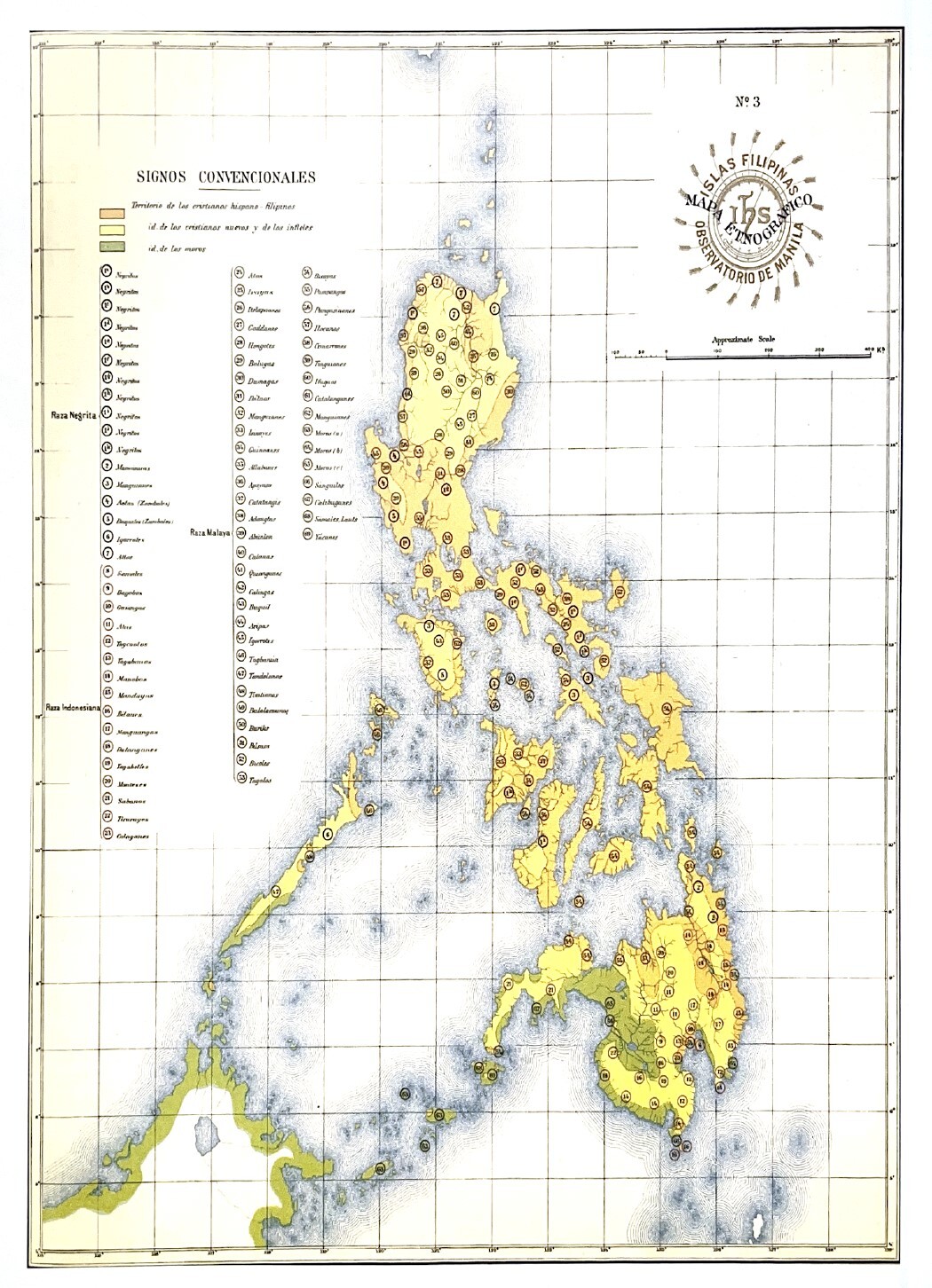
This ‘imperial imagination’ shapes the material and lived geopolitical realities how we think of, and group islands and archipelagos. These are not so much determined by island-to-island migration flows and islanders themselves, but instead by colonial possession and desire. It is especially clear in the creation and naming of archipelagos. The Caribbean is shaped by plantation geographies (Sheller, 2020), while the Philippines and Indonesia are defined by colonial conquest in the Pacific Ocean (Quirino, 2016). ‘Mapa Ethnografico de las Filipinas’ (1899) (Figure 2) shows the categorizing of different ethnic groups around the Philippine archipelago. These categorizations served as a colonial tool to ‘tribalize’, subjugate and create hierarchies through a heterogenous group of islands by the Spanish (Quirino, 2016).
This imperial imagination is rooted in seeing a place as “other” and has its limits in being able to grasp the complexity of what constitutes the place. Maps made by colonizers have failed to capture the vastness of the islands in the Pacific Ocean, or Oceania framed as scattered islands in a vast sea, rather than what Eric Hau’ofa (1999) refers to as a “sea of islands” (p. 152). The perspective of a sea of islands encompasses the myriad of ways islanders traversed and migrated through Pacific waters regardless of island boundaries. Yet it is this imperial imagination’s boundary-making that reproduces a perspective of remoteness and smallness that makes a lasting impact on the lived reality on what it means to traverse islands and be part of an archipelago (Foley et al., 2023).
Thus, it is important to identify what kind of gaze visualizes the narratives of islands? The critique of the ‘tourist gaze’ on islands (Urry, 1990: Picornell, 2020) draws attention to the colonial construction of islands as exotic places ready to host and be hospitable for the western consumer, which overshadows local cultures, heritage, and relations to place: much like the ‘imperial imagination’ which serves as the basis for how space is constructed. This gaze is amplified by the representations through maps that reproduce their values, whether it be unfolded and read on paper, or embedded in our mobile devices.
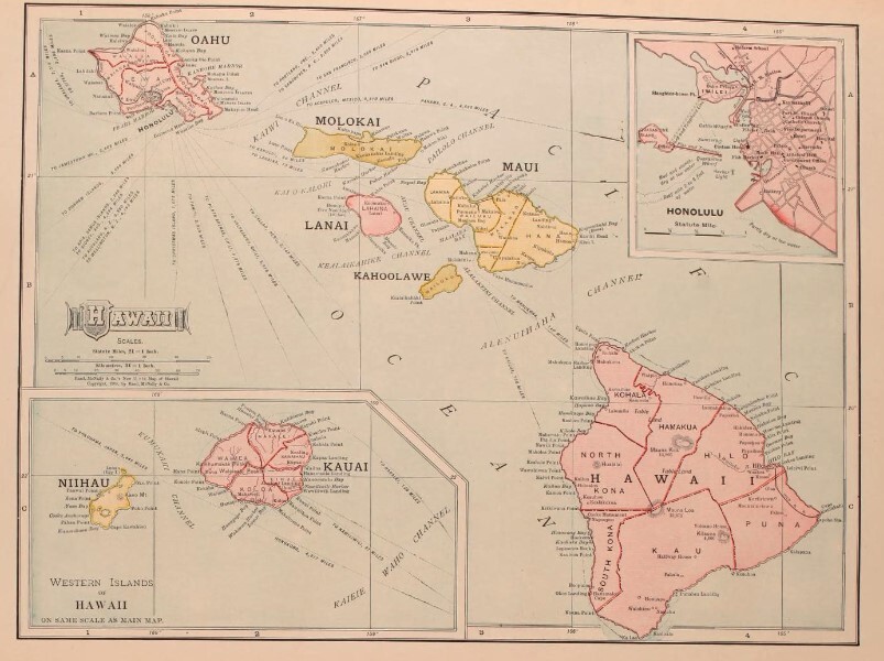
The 1899 book Our islands and their people (Figure 3) is an anthropological account meant to introduce the American public to the newly acquired islands of Cuba, Hawaii, Puerto Rico, and the Philippines. Included in this book is a map of Hawaii. There is nothing extraordinary about this map in terms of appearance, as it bears the conventional markers on a map: title, a graticule or coordinate grid, north arrow, scale bar, all commonplace cartographic elements that give it the appearance of a reference map found in a geography book or atlas today. Is this a colonial map? It is not exactly like maps from the Dutch Golden Age such as the 17th century engravings like the 1617 ‘Spice map’ (Figure 1), which were meant to showcase and market the natural resources available on the islands. They emphasized the (literal) fruits to discover and exploit, making the colonial relationality very apparent. The Dutch would come to establish a brutal trade monopoly in these islands. Centuries later, the map of the Hawaiian Islands in Our islands and their people (1899a) situates and illustrates the eight habitable islands, simultaneously implicating it as part of the settler colonial project to own and possess, and laying the cartographic authority on what it means to know and measure a place. This map is described in the book as putting the “so-called histories” (Olivares, 1899b, p. 418) of the Hawaiian Islands to rest. Through its representation, it sets a totalizing history which showcases how the map inscribes a singular narrative as an imperial object of conquest on the islands.
.jpg)
2.3. Totalizing Views
The colonial map not only exists in the archive, but lives on through the prevalent geospatial technologies used today. Wilmott (2020) articulates that the ways digital geospatial knowledge is reproduced are ‘haunted’ by the role cartography has played in colonizing. “What we see in digital maps (and mobile mapping) is not a historical period distinct from others,” but instead built by legacies, methodologies, practices, and approaches of coloniality (Wilmott, 2020, p. 17). Similarly feminist Geographic Information Systems (GIS) have called out the technology’s positivist ‘God’s eye view’ that enables a disembodied perspective of everywhere from nowhere, when in fact this view is programmed with gendered biases and a false claim to objectivity (Haraway, 1988; Latfin, 1997; Schuurman, 2000)). Furthermore, these technologies often privilege forms of expertise that are less accessible to the communities related to the very land it seeks to map (Reid & Sieber, 2020). With the ubiquity of digital mapping, it becomes critical to consider the coloniality these maps remain embedded in, and how that extends and influences the understanding of place, especially as these tools become part of everyday life.
Most web maps, a tool for everyday navigation, use the Mercator projection. Although providing detailed spatial information of the globe, certain island areas remain blurred. More concerningly is Google Maps’ power in representing national borders and disputed territories. Assumed to be a ‘ground truth’, Google Maps’ borders shift depending on where in the world the map is being viewed (Katz, 2023). In navigating to the widely contested ‘Spratly Islands’, the islands in the sea itself are pixelated and blurred. There are many differing claims to these resource rich islands, but in shifting the perspective from that of nation-state powers, many fishermen also navigate these shores, of which visiting offers a different more fluid relationality, one not defined by conquest. Yet with the ubiquity of Google, islands show that there are still discrepancies, thus calling to question the limits of this tool, and reminding that this ‘eye in the sky’ is not an objective gaze and is embedded within an imperial imagination. Understanding this definition of a colonial map, how it has enclosed on how place can be represented, and also what relationship we can have to the place, makes the need for alternatives all the more necessary. The following sections outline ways alternative cartographies and approaches to the map have refused these conventions and utilized the map as a medium for making representations outside of colonial worldviews.
3. Countering Colonial Cartographic Tradition
Despite cartography having inextricable ties to colonial histories, colonial maps and their subsequent relationships to land, are not the only way to make a map. Alternate cartographies have always existed, and marginalized people have engaged in world-building practices and creating their own imaginaries of what is possible outside of Western categorization (Ghisyawan, 2022; Rivera, 2023; Rose-Redwood et al., 2020). This section draws from alternative, counter, and critical approaches to map making that focus on islands and archipelagos that were created by islanders. These practices fall under different names and conceptualizations, so rather than separate these practices by their theoretical approaches and discursive categorizations (e.g., feminist and queer mapping), we organize them by theme. We then relate these themes to how they can ultimately intertwine into a decolonial approach towards mapping islands. This is not meant to be an extensive history or listing of critical and counter cartographic traditions, but rather serve to identify common characteristics. Beginning with subverting the gaze, we discuss how these various critical approaches in mapping upend the dominant view perpetuated by colonial mapping. Then we explain how these approaches have also worked to foster meaningful relationships, and thus, building relationality through the mapping practice. Finally, we show how these practices work to showcase the plurality of place and counter colonial maps through asserting imaginaries that seek to contest and question the ‘imperial imagination’ and construct alternatives.
3.1. Subverting the gaze
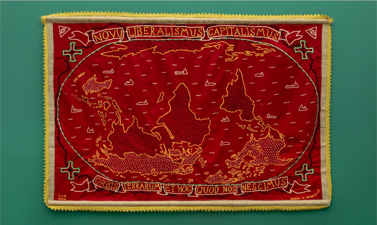
In the exhibit ‘Beyond the god’s eye’, conceptualized by counter-cartographer Cian Dayrit (2018), there is an eye-catching embroidered tapestry that represents the world upside down, with global north and south highlighted in different colors as container ships (resembling islands) sail across (Figure 4). Made visible are the ‘god’s eyes’ on the upper corners, watching from above as the topography unfolds. This composition of a world upended, is a useful entry point into the map’s power to subvert a dominant gaze. This work foregrounds his other counter-maps of land dispossession in the Philippines called ‘Frontiers of struggle’. Van Houten (2024) details eloquently in his introduction to Free the map that cartography is an act of artistic representation, in which what was rendered visible is a strategic curatorial choice, thus opening the question of what it means to represent beyond a gaze that serves colonial and imperial projects. ‘Frontiers of struggle’ goes beyond the god’s eye to depict scenes of land dispossession in a situated geography. Figures appear trapped in borders as they are surrounded by mechanisms of violence. Here colonial maps are collaged in the background, while painted over in red are scenes of people getting evicted from their land. By juxtaposing this over the seemingly neutral and empty historical maps, Dayrit questions what the map is representing and who it serves and draws attention to the actions of dispossession that come as a product of colonial cartography.
__by_cian_dayrit_(2019)_with_henry_.jpg)
Dayrit’s (2019) maps operate under the genre of counter-mapping, which is a practice that originated from the need to assert situated and local knowledge, particularly that of Indigenous communities, in the face of land dispossession and the continued violence of coloniality (Cohen & Dugan, 2021; Pramono et al., 2006). This is with the purpose of challenging dominant and oppressive structures that invisibilize violence and centering marginalized communities’ relationship to place. From that counter-mapping has grown to intersect with other social justice issues, all with the intention of drawing attention to spatial injustice, invisibilized experiences, and working to visually represent that through a map (Kollektiv Orangotango, 2018). In a similar vein, work under feminist cartography has been vital in showing the intersections of race and gender in place, particularly calling attention to the all-too-totalizing view of geospatial technologies (Kwan, 2002; Latfin, 1997; McLafferty, 2006) and calling for place-based situated knowledge (Haraway, 1988). This is rooted in unveiling realities that are often dismissed through dominant mapping practices. Thus, these practices open up how critical theory can inform a mapping practice that not only seeks to reclaim place, but also puts into question the authority and legitimacy of representations generated through ‘the god’s eye,’ ‘colonial gaze,’ and especially in consideration of the island depictions, a ‘tourist gaze.’ This contrasts the complicated lived realities of islanders, including their struggles and challenges. Subverting the gaze then becomes a chance to map back against this dominant power, and create counter visualizations and narratives.
The gaze of ‘who is looking’ has long been determined by a colonial force strategically curating what to make invisible and hide (Mirzoeff, 2011). Although the counter project of asserting visibility by drawing attention to marginalized experiences of places that are overshadowed by dominant cartography is important, it is not without tensions. This is especially as it is not always safe or appropriate to visibilize something through a map (Kim, 2015). As an example, visibilizing sacred or sensitive information could further endanger or put a subject at risk. Scholarly work on Indigenous mapping has also drawn attention to the importance of acts of ‘refusal’ (McGurk & Caquard, 2020; Rivera, 2023), especially when the project runs the risk of reproducing colonial power dynamics and tokenizing participants. What is integral then, is fostering agency with those contributing knowledge to the map to critically decide what is at stake when putting something on the map and to decide what should be visible. This agency is integral for building reciprocal relationships, which is important in moving past the often-extractive tendencies of colonial cartography.
3.2. Building relationality
The map is also the types of relationships that are being built through it, whether it be through different communities, the land, and other species. Alternatives to colonial cartography work to open possibilities beyond what is on the map through intentionally deciding what relationships are fostered and created through the map-making process. This is a way to amend the unequal colonial relationships that become performed through the dominance of a colonial map. There is potential within the process of making the map to move from colonial relations of ownership and extraction towards fostering generative relations, dialogue, and collaboration towards organizing for action (Orangotango, 2018; Sletto et al., 2023). Sletto et al. (2023) conceptualizes “other mappings” to describe the diversity of processes that “point to situated relationships between land and body” (p. 149), thus drawing deeply from cuerpo-territorio, which is a practice working to address the fracturing of land and body (otherwise known as the cartesian split). Alternatives to colonial cartography have long explored how a mapping process can validate rather than alienate spatial ontologies outside of colonial relationalities of extraction, consumption, and ownership (García, 2020). This is not only through critiquing the cartesian split, but also through designing the mapping process to be engaging for those involved, and making sure the map speaks to their experiences. This in turn opens up the mapmaking to be something that results from the interaction and collaboration that creates the map (Kim, 2015). This changes the perspective from the map as an object, and instead recenters the map-making process.
Returning to Dayrit’s (2018) work, his cartography practice is informed by close collaboration with agricultural and peasant communities who experience displacement firsthand, and connects their struggle with artists, unions, and academics. This draws attention to the importance of social relationships in cartographic practice and the potential for the map to build solidarities across communities. While colonial relations seek to divide, categorize, and draw barriers amongst communities, humans, non-humans, the land, and environment, what these alternatives seek to draw attention to is the potential of engaging in making a map that cuts through silos and instead highlights interconnectedness. This inspires collaborations as forms of resistance, achieving shared goals, as well as renewed relation amongst each other and the land. Furthermore, seeing maps as a process invites more creative and experimental approaches (McGurk & Caquard, 2020) with a better focus on how the map can be co-produced.
However, building relationships and participatory processes is not without its tensions. Although these alternative approaches, in theory, put into question the role of an ‘expert’, whether it be expert cartographer or of the land and place, there is still the challenge of negotiating unavoidable expertise. This is especially the case with those trained in using certain technological processes (Reid & Sieber, 2020), which can risk tokenizing communities (Kim, 2015). In trying to create better relations, it is not always clear how power dynamics can be negotiated as not to reproduce harm and hierarchy. It is important to consider how a mapping approach can stay accountable to the communities it serves and desired impacts. As technocratic expertise can create complex and, at times, alienating contexts (McGurk & Caquard, 2020; Pramono et al., 2006; Reid & Sieber, 2020), interrogating positionality is important to fostering generative relations (Rose, 1997: Nimführ & Otto, 2021).
Besides relations between the land and body, each other, and the environment, alternative cartographies also seek to bring in new relations within the self. Ghisyawan’s (2022) argues through their participatory mapping project with queer women in Trinidad that their methodology called ‘subjective mapping’ created a decolonial approach primarily through decolonizing the self. Inspired by Audre Lorde’s (1984) use of ‘the erotic’, Ghisyawan (2022) sought to map lived experience in the margins, and queer embodiment as legitimate knowledge. Furthermore, their work explored what it would mean to map onto cartographies that have erased queer women’s bodies. This form of meaningful participation, which opens a mapping process to include experiences which are often left out of the map, works to subvert the dominant gaze and to legitimize and reclaim a relationship to place. By doing so, the map can become more representative alternative experiences and thus has the potential to generate alternate imaginaries of a place.
3.3. Plurality of Place
If the ‘imperial imagination’ restricts the future to a continuation of colonial modernity, asserting counter imaginaries through mapping is a reminder of the worlds that still persist despite the dominance of coloniality, and the alternative worlds that could be. There is an inherent multiplicity of experiences within places, and while colonial maps have worked to portray colonial interest, there is the potential of the map to curate different experiences within place that evade colonial prescription. Turning back towards Ghisyawan’s (2022) work with queer women in Trinidad, she further describes her mapping project as going beyond representation. She explains how closely working with queer Trinidadian women in utilizing arts-based approaches allowed for certain experiences to transcending borders. Ghisyawan’s subjective mapping, follows Sletto’s (2023) conceptualization of ‘other mapping’ as encompassing different temporalities, knowledge, and narratives. We argue these mappings open up possibilities for asserting alternate imaginaries to colonial time, histories, and stories.
Critically informed, creative, and arts-based counter cartographies have shown the potential for a map to encompass more than static representation and territory. However, there remains a struggle of translating these maps across epistemologies, communities, and negotiating cartographic convention and legibility. Kelly (2023) addresses this by conceptualizing a mapping practice informed by black feminist theory which she calls a “re-tooling” (p. 663) of the map through rethinking traditional cartographic techniques. She does this by proposing a rethinking that emphasizes context, critically considering power structures, and being transparent about curation that allows for collaboration and dynamism within cartographic technique.
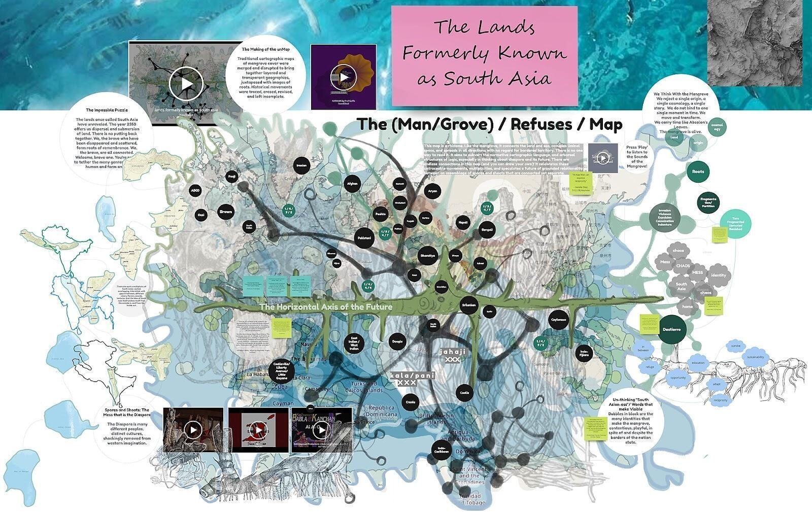
An example of collaboration and dynamism in action is a speculative cartography experiment called ‘The world we became: Map Quest 2350’ (Figure 5) which was a project between artists, poets, academics, curators, architects, and activists (Goffe et al., 2022). Created during the Covid-19 pandemic and via collaboration through an online workshop tool called Miro, this atlas connected solidarities across the globe to envision what justice could look like in the far future. Rather than focusing on colonial entanglements, this project sought to meditate on the intertwined “futures of Black, Asian, and Indigenous people to create a blueprint for a futuristic atlas” (p. 8), paying special attention to ways in which these communities thrive. The map itself is a deep dive into lush colors and creative forms, and begins to illustrate what a pluralistic future can look like. This is further exemplified by the collaborative process of making this map, and how that process itself inspired drawing connections at the intersections between struggles rather than drawing borders between them. This project goes beyond mapping boundaries and instead works to build coalitions across struggles to help co-define pluralistic futures.
The approaches outlined above encompass a diverse range of thinking regarding the materiality, approach, and process within mapping practices. They show how the tools of mapping can be modified to draw upon alternate imaginaries. Furthermore, they also re-think the radical potential of the map to be something different: pluralistic, imaginative, and generative. This is as opposed to being prescriptive through imposing boundaries, definitions, and ontologies. Instead, the process of creating the map and the map itself become an exercise of generating alternative possibilities and knowledges.
4. Towards a Decolonial Praxis for Mapping Islands
The previous section helps tease out what guiding characteristics, modes, and methods can inform a decolonial praxis. In this section, we build on these concepts to outline a framework to help guide decolonial mapping (see Table 1). In the spirit of ‘re-tooling’ the map (Kelly, 2023; Kim, 2015), we offer a set of important dimensions and corresponding questions that can help enable subversion, relationality, and plurality through decolonial mapping praxis. In doing so, we seek to help ground decolonial mapping theory into praxis, heeding Tuck and Yang’s (2012) call that a decolonial approach should not solely remain a metaphor, but rather be materially rooted, for example, by returning land back to Indigenous people. Our framework seeks to counter and challenge the colonial values perpetuated by cartographic convention by actively embedding the core values of subversion, relationality, and plurality into the mapping process. We begin by first clarifying our understanding of decoloniality in this context.
Decoloniality is most powerful when it is context specific and put into practice in a way that re-centers marginalized ways of knowing (Liboiron, 2021; Thambinathan & Kinsella, 2021), as it is more likely to emphasize action and draw attention to the necessity of a decolonial approach to enable real material change. Decoloniality is greatly informed by theoretical thought that can inspire certain value, these values can inform how we should act. As the discourse surrounding decoloniality develops, it is important to make it more than an empty signifier (Tuck & Yang, 2012) and instead use it as a framework to guide change. This is especially as the terms decolonial or decoloniality are not necessarily commonplace phrases (varies through geographies), but rather concepts that have been developed within the realm of academia (Cusicanqui, 2019; Walsh & Mignolo, 2018). This is why it is important to break decoloniality into a context relevant praxis for it to become actionable and prompt different ways of doing.
The alternative approaches outlined in the previous section illustrate the potential to approach the map critically and begin to reimagine it as a basis for decolonial methodology. We emphasize the decolonial approach, as it encompasses a thinking from the margins (hooks, 1989), and and as a way non-western spatial ontologies and epistemologies can be centered (Rose-Redwood et al., 2020). There is no singular definition of a decolonial approach, and the terminology itself comes with a plurality of meaning; after all, if there are many histories and permutations of coloniality, there are many forms and manifestations of decoloniality (Cusicanqui, 2019; Ferdinand, 2021; Liboiron, 2021).
With that in mind, how can a decolonial approach be relevant for island contexts, and what would that mean for mapping practices? This is especially relevant in addressing concepts of islandness, which seeks to describe the sociocultural constructions unique to islands (Foley et al., 2023). Islands are diverse sites of migratory crossings, identities, and cultures, which need to be taken into account when thinking of a decolonial approach. Islands, particularly those in the Pacific and Caribbean, can be understood as what Tsing (2015) articulates as containing assemblages of contaminated diversities, composed of encounters shaped by extermination, imperialism, and displacement, as well as unique comings together and collaborations between unlikely groups of diverse cultures. This makes islands particularly challenging to fit into decolonial frames as they escape binary understandings, and are often the product of complex cultural amalgamations.
Through centering subversion, relationality, and plurality the hope is that mapping can become generative, rather than prescriptive. This means that the process of making the map itself can connect different communities, and create a renewed sense of validation for experiences which are not typically considered in a map. From that there is the hope that the map can be something to generate and help actualize desired realities, rather than impose colonial agendas. Prioritizing the value of subversion entails unsettling the imposition of the colonial gaze, thus putting into question the embedded coloniality in place. The value of relationality means moving towards thinking of how a process can foster decolonial relationality that is collaborative, reciprocal, and critically conscious of power dynamics. Finally, the value of plurality is critical to a decolonial praxis, as it seeks to question how centering islands can make way for a multiplicity of imaginaries of the future. The point is not to follow these values in a linear context, nor try and encompass all the dimensions, but instead use them to foster reflexivity in the process of building a decolonial mapping approach.
4.1. Subversion
Part of decolonial work is reckoning with the colonial entanglements embedded within everyday life. This is especially the case given that in island contexts, there is no clean break as coloniality has shaped cultures, ways of life, and island identity. This is partially due to the epistemicide of colonial violence that centers colonial and western ways of knowing rather than indigenous or place-based generational knowledge. Therefore, incorporating subversion into a practice, means visibilizing coloniality, whether that be recording lesser-known aspects of colonial history or how colonial legacies manifest in present day. It also invites incorporating non-western epistemologies and ontologies and makes an effort to show these worldviews through the map, or through re-centering local place knowledge into the mapping process. To subvert the gaze can take place as questioning and redirecting the perspective of the god’s eye. This can be done through putting into question what aspects of life have roots in imperial conquest. Embedded within this effort is a challenging of colonial power through unsettling colonial structures, systems, and knowledge.
An example of how this is actualized in mapping can be seen through the map of ‘Taino names of Caribbean Islands’, which effectively platforms the Indigenous names of the Caribbean islands but also puts into question why these names are not used. Despite using normative cartographic convention, this map still manages to make the necessary re-tooling that unsettles colonial norms. What this map does is lift over a layer of coloniality, particularly within toponyms (what a place is called), to unsettle, subvert, and map back from the colonial gaze. The map offers a space of representation for marginalized knowledge by becoming embedded in aiding decolonizing how these islands are named, perceived, and by whom.
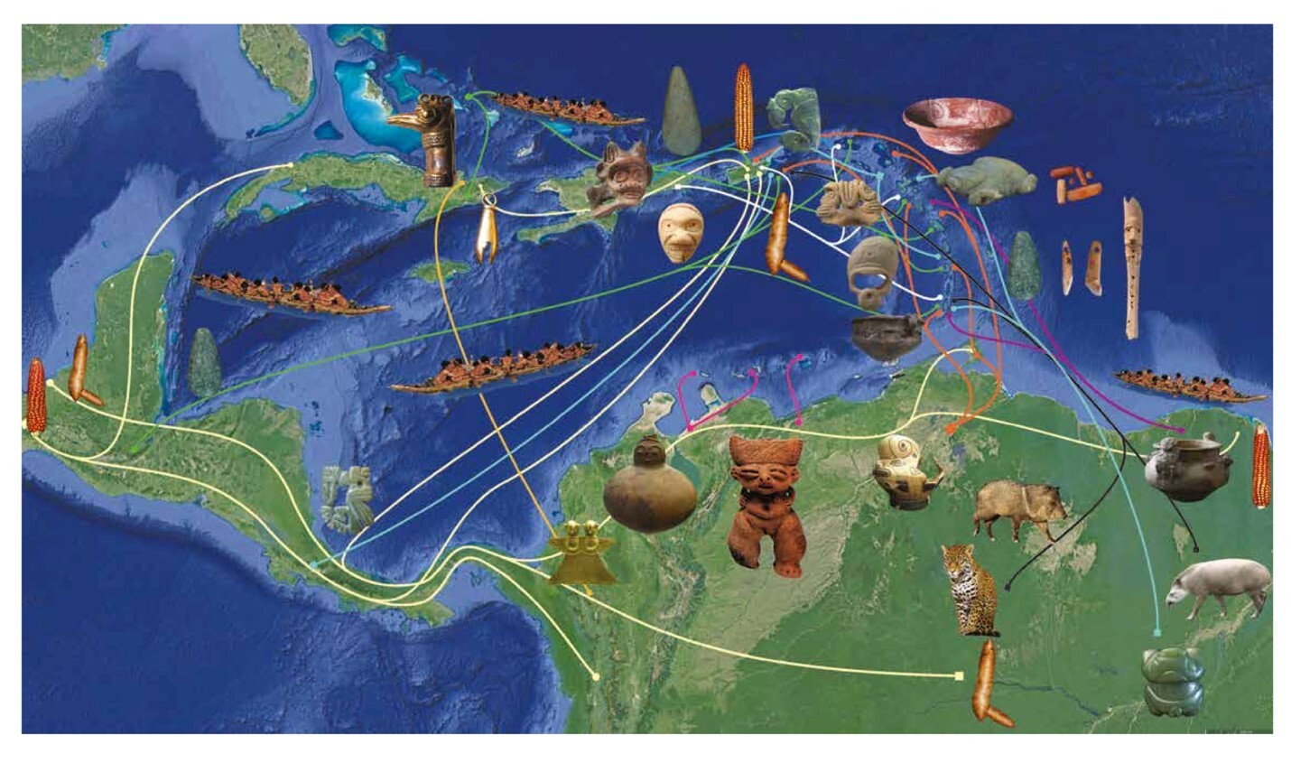
A 2021 exhibit called ‘Caribbean ties: Connected people then and now’ takes this a step further by showcasing maps of the Caribbean under the framing of Indigenous culture and ways of life (Figure 6). These maps show the exchange of objects and ideas between the Caribbean and neighboring continents. It draws from archeological and historical research across the islands. It invites an imagining of the way of life that decenters the islands colonial connection and instead focuses on the interconnectedness of islanders. These maps ask: if the gaze of the colonizer is not determining what relations are valued on the map, what therefore is revealed? Whose stories, ways of life, become centered? These maps also assert an Indigenous history of the Caribbean that is often overshadowed, invisibilized, and forgotten. It becomes a way of unsettling and subverting settler colonial time and instead gestures towards recentering place and overshadowed ontologies.
4.2. Relationality
A vital part of decoloniality is departing from extractive relations towards more reciprocal relations, whether that be with each other, non-human actors, or the land (Sheik, 2021). How can reciprocal relations be a value embedded within a mapping process? This characteristic is therefore meant to describe mapping projects that connect with those historically left out of the mapping process, yet still contain valid spatial knowledge. There is much to be said about the map as a boundary object (Harvey & Chrisman, 1998), which is a medium to forge collaboration amongst diverse stakeholders. However, it is important to be mindful of the local cultural context, of which cartographic practice and familiarity differ (Kim, 2015). Even within this collaboration, a decolonial and critical approach to cartography means remaining mindful of the power dynamics at play and ensuring not to tokenize participatory mapping projects and communities. While certain expertise is unavoidable, how can a mapping process be designed to include exchanging skills and knowledge for the benefit of communities? Relationality is also meant to include other species, and the environment as well. Furthermore, how can a mapping practice open-up agency and decision making over what and how to map? Through engaging in a collaborative and co-learning processes, this invites thinking about making maps as a way of sharing knowledge across different spheres. Going beyond subversion, how can building on reciprocal relations also help build solidarities across different decolonial movements and various contexts?
Nimführ and Otto (2021) articulate that the challenge in a decolonial approach in islands is how can it better “take into account the rich spectrum of island perspectives and their diversity in knowledge production, while being aware of complexities and tensions to avoid demarginalizing already marginalized actors” (p. 10). Therefore it is important to strengthen relations and build solidarities. Thus, this value system encourages not only criticality within what relations are being built, but also encourages an ongoing reflexivity as to not tokenize, or co-opt certain identities and relations.
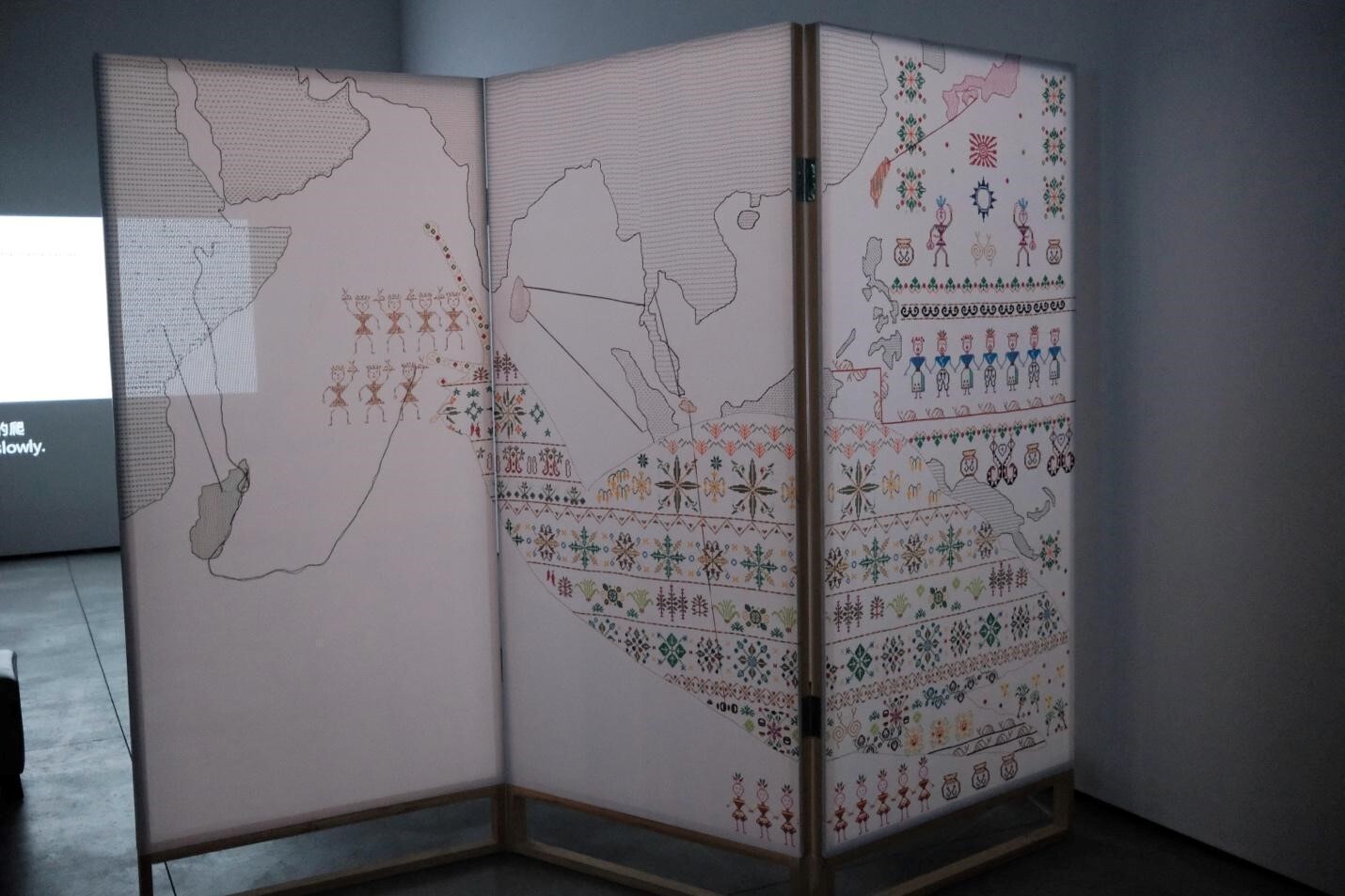
An example of a non-extractive relationality can be seen in the embroidered map in Chang En-man’s installation ‘Snail paradise’ (Figure 7). Central to this installation is a multipanel embroidered map which charts Southeast Asian islands from the perspective of not only Austronesian migration, but the incorporation of snails (originally a colonial imposition) into the diet and cultures of these island communities. Chang utilizes different embroidered symbols drawing from the Indigenous Paiwan culture, while also creating her own inspired by learning of this history. In doing this, she collaborates with different ways of tracing migration, and cultural perspectives to create his map. In utilizing embroidery, she also references the cultural practice of the Paiwan culture in which she draws from, which was historically used to record and archive history. All in all, the purpose of the map and the larger installation it is embedded in, Chang (2022) states, is to “focus on how Taiwanese indigenous people, to their own benefit, transformed certain effects of their colonizers” (p. 36). Part of the installation features a documentary, and by weaving in her process of working directly with Indigenous Paiwan communities as well as working alongside their traditional cooking and weaving practices, she thus shows how these processes are tools for resisting colonization. The process of map-making itself is key in producing these reciprocal relations. In emphasizing this, Chang draws attention to the transformative qualities of decoloniality, and how islanders are able to survive and thrive, and maintain reciprocal relationality, despite colonial harm.

Relationality leads to thinking about what types of mapmaking process are relevant for who is making the map. This asks how a decolonial praxis to make way for creative, or more unconventional approaches. Thus, examining how the map functions as a boundary object (Harvey & Chrisman, 1998) vis-a-vis a praxis of collaborative relationality can forge pathways in which local knowledge can be better incorporated in informing how sustainable island futures are envisioned. This is with the goal of showcasing how cartographic practice can work with local and Indigenous island communities to envision sustainable futures. Therefore, adding this vital local knowledge to the conversation on how island sustainable development can better include sustaining communities, cultures, and ways of life.
4.3. Plurality
Decolonial theorists have broadly cited work within the Zapatista movement, particularly their call to action for a “world in which many worlds fit” (Escobar, 2018, p. 17). Similarly, plurality within decolonial mapping praxis invites thinking of a “map where many worlds fit.” This is with the understanding that maps are intentionally curated, visualizing certain aspects over others. Plurality does not mean that a map include everything—no map could—but instead think of ways mapping can be dynamic. Emerging mapping approaches are increasingly engaging with alternative visions or dreams. This is in order to not just deconstruct or present an alternative historical account (although that is still important), but to also present the diverse possibilities of ways of being and the future outside of a colonial frame.
Plurality is important because it counters coloniality’s totalizing singular view of the world, and the way the world should be. This is with the purpose of acknowledging the multitude of lived experiences and ontologies that exist in a place. Islands are especially such rich sites of this. Thus, this becomes a way to map against representations of islands as small, to be consumed by tourism, or as a tropical paradise for the privileged to escape to. This is what this value also aims to open in its pointing to alternative possible futures, ontologies, futures, and imaginaries. It is a call towards what worlds could be actualized as a result of mapping. After all, if the map is a tool putting forth imperial imaginations, what is the potential of using it to instead further decolonial futures?
Moreover, islands have often been the site of radical imagination i.e., utopias often centering whiteness; yet, ironically, these sites often reproduced a lot of dominant and colonial forms of imagination. There is a potential to reclaim the radical potential of imagining futures of islands in not only representing existing and very real struggles (crucial of course), but also orienting radically towards dreams and possibilities. However, not those of people who have never been to these islands and simply dream them up on paper, but those who live in island settings and understand the particularities and interdependencies between islands and the rest of the world.
As island communities live in colonial realities in which vestiges of colonial conquest (e.g., Dutch forts scattered across the globe) remain erected, reminders of colonial pasts are prevalent. There is great potential in mapping to unsettle and tell those histories from other perspectives, but how can they be reckoned with towards the future? The curatorial statement of ‘VOC, sea monsters, artillery fire, and them: 400 years of Fort Zeelandia’ prefaced this landmark mixed-media exhibition:
Today, after four hundred years since the establishment of the fort (Zeelandia), the symbolic meaning of this exhibition is no longer to re-examine the influence of the invader’s colonial regime, but instead to open-mindedly unearth, comprehend, and re-imagine the exchange of culture, species, and resources at the time. (VOC, Sea Monsters, Artillery Fire, and Them: 400 Years of Fort Zeelandia, 2024, p. 9)
This exhibit blended historical maps and documents alongside contemporary works of art and the installation contended with colonial history in a way that gave clues to decolonial futures by laying the groundwork of artistic examples that opened up new narratives of islands and decolonial crossings. The exhibit re-examined the past as a way to allude towards what kind of present cultural exchanges could be, interweaving many storylines, lived experience, and histories within its narrative telling of the story of this island city.
The motivation of thinking through a map as putting forward plural island imaginaries is to gesture towards possibility. In the decentering of colonialism as the primary way of being and knowing in the world, and in this case of representing, narrating, and gazing the world, how does that make space for alternate imaginaries? How then, can a map serve to capture, visualize and put forth these imaginaries as a future that is more collectively desired, and hold space for the inevitable differences between diverse views?
5. Conclusion: A Call for Cultivating Decolonial Island Futures
In examining the coloniality of the map, we recognize the ways it has served colonial and imperial projects of conquest, violence, and extraction. Identifying this reveals the ways in which the map has supported harmful and unequal power relations, particularly on islands. The representation through colonial maps have supported a dynamic in which islands can be captured, owned, and extracted from. Colonial maps have, in turn, presented islanders and their islander communities and ecologies as disposable. However, colonial maps have never been the only method to make a map, and there have long been alternatives outside of colonial map-making that seek to subvert the colonial gaze, foster more reciprocal relations amongst those making the map and towards the place being mapped. These works to assert alternative imaginaries outside that of colonialism. Combined with thinking alongside decolonial approaches, these alternative visualizations invite ways of map-making that continue to unsettle the colonial gaze, histories, and structures that have been taken as normative, foster genuine reciprocity and collaboration, and ultimately put forth and enact decolonial futures.
We identify three values that play an important role in decolonial mapping practice: subversion, relationality, and plurality. These values each have several dimensions that help describe how they can be understood and enacted. Subversion attends to changing the perspective guiding what is being mapped. Relationality seeks to describe how the map is being made and what type of relationships are being built in the process of mapping, or through interacting with the map. Finally, plurality seeks to engage with the pluriversal nature of decolonization and how mapping can be a powerful means to imagine better futures. Drawing from diverse examples of decolonial mapping practices in island contexts, we tease out what it means to embed these three values in mapping practice. In doing so, we strengthen and clarify important aspects to consider amid the growing interest in decolonial mapping.
Through identifying these values, we hope to contribute to the spheres of critical and counter cartography, decolonial theory, and islands. What we offer is a way of connecting these realms, and a way of building upon their thinking. By combining thinking of decolonial theory alongside critical and counter cartography, we hope to link towards how concepts within decoloniality can be put into practice. Counter-mapping practices, and alternate approaches tangibly show how to break free from colonial conventions towards putting forth alternatives to the imperial imaginations. Islands further add to this by grounding these maps in a complicated geographic context, that faces marginalizations from coloniality. This makes what is at stake with mapping ever more urgent. Maps that can depict islands otherwise, and really draw from their unique cultures, ontologies, and positions can put forth visualizations that can help inspire and plant seeds for not only how we read the history of islands, but also how we can imagine their futures.
This paper calls for framing decolonial futures as something that is cultivated rather than produced. This is in reference to Sheik’s (2020) work which turns to the verb cultivation rather than production, especially as the latter is associated with capitalist modes of working, whereas cultivation goes hand in hand with thinking of generative ways of being. The goal with decolonizing a mapping practice may begin with unsettling coloniality, but should move towards how we can create representations, practices, and systems that are generative. Cultivating inspires the feeling of nurturing and growing which is the type of ethics of care needed for transformative change. Returning to maps, when the perspective of a map is looking out from an island, how, in turn, is the world seen?
Thinking with islands makes way for “challenging colonial mainland thinking” (Foley, 2022, p. 1802) as well as engaging in complex and at times contradictory ways of being. Decolonizing mapping practices in islands offers a praxis to work alongside methodology. In moving away from the oftentimes too deficit-based, or hyper romanticized colonial gaze on islands, we provide this praxis as a compass for thinking about how the map can imagine islands otherwise. It is also through thinking about decolonial approaches alongside the rich context of islands that can also help reshape and revisit what it means to map.
Funding
This research was completed with the support of the Copernicus Institute of Sustainable Development Early Career Research Fund from Utrecht University.