
1. Introduction
In the early phase of island studies, scholars emphasised on archetypal (e.g., marine) islands. Over time, however, they moved away from this central focus and expanded the scope of island studies by considering “almost-islands, possessing many attributes of islands without being islands” (Fleury & Hayward, 2021, p. 158). Thereafter, as the concept of ‘islandness’ gained prominence, researchers began to analyse islands through an interdisciplinary lens (Baldacchino, 2004, 2006; Foley et al., 2023; Hay, 2006; Vannini & Taggart, 2013). Grydehøj (2017, p. 3) further argues that, to develop the discipline, it is necessary to “not only continue deepening its internal theoretical understandings but also reach out to other fields and regions that have received limited attention within island studies.” However, extensive theoretical and empirical discussions of almost-islands, such as river/fluvial/channel islands (also called chars in South Asia), are yet to receive the attention they deserve within island studies.
Islands are usually defined as landforms surrounded by water or waterways that are smaller than sub-continents, where “permanent islands—such as continental fragments, exposed lands in lakes, oceanic volcanic islands and coral reefs, and barrier islands—are discussed more extensively, while [im]permanence is generally not given much consideration” (Osterkamp, 1998, p. 530). Fluvial islands are, however, relatively impermanent (Momin & Chakraborty, 2023), as they may disappear due to river currents before permanent vegetation becomes established. As a result, they are not considered sufficiently stable to be regarded as islands. Consequently, fluvial islands have not yet been able to secure their place within island studies. Although researchers, such as Lahiri-Dutt (2014b), Baruah & Mukherjee (2018), Hong (2020), Fleury & Hayward (2021), Sudhindranath & Lourdusamy (2023), and Du et al. (2024), have established river islands through their studies, they have fallen short of adhering to the fundamental premise of ‘Nissology’, a term coined by Grant McCall (1994, p. 1), which advocates “the study of islands on their own terms,” i.e., emphasizing the perspectives of islanders (insiders) by bringing the experiential dimensions of island life to the centre of scholarly discussion. Baldacchino (2008), on the other hand, mentions that although the insider/local perspective is important, it should not be regarded as the only means of understanding islands. He highlights that “all forms of understandings are needed for a fuller, deeper appreciation of the island condition” (p. 50).
We argue that, for a comprehensive understanding of islands, both these perspectives are important and dialogue between insider and outsider viewpoints is necessary. Therefore, we refer to the concept of the ‘outsider within’ position as useful for understanding both the environmental and social realities (Collins, 1991). This is equally relevant to the study of river islands (chars), where lived experiences, environmental transformations, and external observations remain intertwined. This article seeks to understand chars through an approach that bridges the gap between the position of the observer (outsider) and the experiences of char dwellers (insiders), thereby proposing for a broader epistemic framework.
The aim of this study is to develop a comprehensive understanding of chars in the large river systems (the Brahmaputra and Ganga) of South Asia by identifying the existing knowledge gaps in char studies and investigating the geographies that exist between land and water. Concomitantly, we examine how chars are continuously (re)formed through alluvial and diluvial processes. Further, we analyse how char dwellers respond to the changing geographies through their adaptive knowledge and survival strategies. Through this, we try to understand the reciprocal relationship between the geographies of chars, its changing nature, and the adaptations of the people living there.
This article is divided into three sections. The first section examines the epistemological limitations of char studies in South Asia. The second section is divided into three parts, which contribute to the formation of a comprehensive analytical framework for understanding chars. This section discusses why land and water should not be treated as separate entities in these geographies. It also analyses the changing morphology of the Brahmaputra and Ganga rivers in selected char areas. Thereafter, we discuss how the char dwellers manage and adapt in their everyday lives, reflecting an amphibious nature of survival in these geographies. The final section presents an integrated approach for the study of chars in South Asia.
2. Methodology
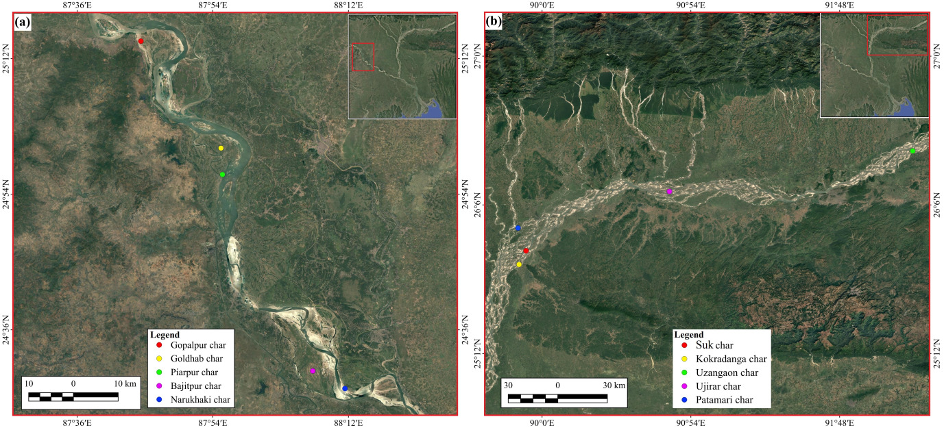
A mixed-methods approach, including qualitative fieldwork and quantitative GIS analysis, is used to study the chars within a ten-year (2015-25) timeframe through our (both authors’ long-term observations) fieldwork in the chars of the Ganga and Brahmaputra rivers. A total of ten chars, five each from both rivers, were selected. Among the chars along the Ganga River in West Bengal, we selected Gopalpur, Goldhab, and Piarpur chars in Malda district, and Bajitpur and Narukhaki chars in Murshidabad district (Figure 1a). Along the Brahmaputra River, we selected Suk char and Kokradanga char in South Salmara-Mankachar district, Patamari char in Dhubri, Ujirar char in Barpeta, and Uzangaon char in Morigaon district in Assam as our study sites (Figure 1b). The chars were selected from both the rivers based on their specific characteristics, e.g., mid-channel chars (i.e., Bajitpur and Ujirar chars), attached chars (Suk char and Gopalpur char); floodplain chars (Piarpur and Uzangaon chars); isolated chars (Patamari and Narukhaki chars); and ephemeral chars (Goldhab and Kokradanga chars).
To understand the changing environment and the ways of life of the people living there, we visited these chars during both the dry and wet seasons. We conducted in-depth interviews and participant observations with 48 people living in the selected chars, including 22 from the Ganga River and 26 from the Brahmaputra River. The participants included cultivators, labourers, boatmen, shopkeepers, businessmen, land surveyors, and other char dwellers. By spending extended periods with these participants and listening to their life stories across generations, we tried to understand the char formation, livelihood practices, mobility, and how they experience the changing environment of land and water within dynamic geographies. The collected qualitative data were analysed mainly in a thematic way based on our direct observations and char dwellers’ narratives. Rather than focusing solely on the physical aspects, we emphasized the social and human dimensions of char life too, so that we do not overlook what Cortesi (2025, p. 76) ascribes as the “ecology of absences and the aesthetics of ecology,” which was also true in the case of the chars of the Brahmaputra and Ganga rivers. These South Asian chars “are not only coproduced by nature and culture, but constitute a blend of water and land where the two are merged with each other imperceptibly and changeably” (Lahiri-Dutt, 2014b, p. 507).
Although both rivers have different characteristics, the Ganga is a meandering river that changes its course slowly (Rudra, 2010), while the Brahmaputra is a braided river that changes its channel rapidly (Coleman, 1969). To understand the variability of these two rivers, we selected two ephemeral chars (Goldhab char along the Ganga and Kokradanga char along the Brahmaputra River) and further classified them through long-term (2000-25) and short-term (2020-25) transformation. To analyse the spatial and temporal changes in these two chars, we collected satellite imagery of Goldhab char for 2000, 2005, 2010, 2015, 2020, and 2025, considering the relatively slow rate at which the Ganga changes its course. In contrast, because of the relatively rapid changes in the Brahmaputra, we collected satellite imagery of Kokradanga char for 2020, 2021, 2022, 2023, 2024, and 2025. These images were obtained from the United States Geological Survey (https://earthexplorer.usgs.gov/) and the Copernicus Data Space Ecosystem (https://dataspace.copernicus.eu) and were analysed using Geographic Information Systems. In addition, we measured the area of erosion and accretion along the river channels surrounding these selected chars.
_ganga_and_b)_brahmaputra_river_*chars*.png)
Our study emphasizes a different perspective rather than relying on a single perspective of chars. Therefore, we have tried to integrate the geographical, morphological, and anthropological dimensions of chars to reduce the gap between the positions of observers (outsiders) and char dwellers (insiders), and to develop a more nuanced framework for studying chars in South Asia.
3. (Re)thinking chars in South Asia
The chars are “pieces of land that rise temporarily,” emerging from the shifting river beds (Lahiri-Dutt, 2014b, p. 22), where uncertainty is not an exception but a condition of being (Chakraborty, 2017). Although some chars may persist for decades, most remain unstable, particularly in South Asia (J. Mukherjee & Lahiri-Dutt, 2021). This is because the South Asian rivers remain dry for months but suddenly burst into life with the onset of monsoon season. During this monsoon, the water flow becomes so intense that it often overflows the banks, causing floods and erosion. At the same time, the rivers carry large amounts of sediment with their flow (R. Sinha & Latrubesse, 2020). Once the water flow recedes, sediment accumulates on the riverbed and along the banks, gradually forming new impermanent land (Chakraborty, 2009; Lahiri-Dutt, 2014a).
Chars are, however, not only temporary landforms but also an imprint of the everyday lives and experiences of the people who inhabit them. The lives of char dwellers are also connected to the changing dynamics of the river. Therefore, viewing the everyday lives of the dwellers separately from the physical processes of the river leaves aside an important dimension of char realities unexplored. To understand chars, it is thus necessary to consider the experiences of the people who inhabit them alongside their changing geographies.
Our association with these changing landscapes has been beyond the observation of the chars as geographical spaces; our relationship for a decade has enabled us to develop a bond with several sections of char dwellers along the Brahmaputra and Ganga rivers. During this period, we have conversed with residents while travelling by boat, walking along muddy tracts and sandy terrains, and sitting in their courtyards and neighbourhood tea stalls. Such long-term engagement has enabled us to observe closely the everyday lives of char dwellers and the environments of their sustenance. Over time, these experiences have led us to realise that the meanings attached to rivers and chars by their inhabitants can offer insights that may not be fully captured through cartographic representations or instrumental views based on satellite imagery. In particular, approaching chars through the experiences of their inhabitants reveals important dimensions of land, water, flows, sediments, life, and mobility within these riparian zones.
This long-term engagement has also taught us that riverine geographies cannot be adequately captured through static maps, because it constantly changes over time, season and flow of the rivers. The limitations of static representations become particularly evident during the monsoon when floods, erosion, mud, and unpredictable water flows often restrict movement across the chars. These difficulties are further compounded by inadequate transportation, making travel from one place to another extremely challenging. During this season, the river appears to spread across the entire landscape; the boundaries between land and water disappear, and the horizon merges into an endless sheet of water (Lahiri-Dutt & Samanta, 2013). In such circumstances, villages that were accessible on foot during the winter became isolated, accessible only by boats that navigate through the paths along which we walked during winter. Conducting fieldwork during these months becomes an arduous task for any researcher. Yet, it is precisely during these times that certain characteristics of the riverine geographies become apparent and evident, as the chars provide insights far more engaging than those that cartographic maps or satellite images can offer.
These observations are particularly relevant to large rivers such as the Brahmaputra and Ganga, where the relationship between land and water remains in continuous transition. In such environments, the morphology of riverine lands remains in a constant state of flux (Oberhagemann et al., 2021), as chars emerge, submerge, and re-emerge in response to changing water flows, sediment deposition, erosion, and seasonal transformations (Baruah & Mukherjee, 2018; Momin & Chakraborty, 2023). These physical transformations directly affect the spaces in which people live, as they are closely intertwined with the everyday lives of char dwellers. As the river course changes, the char dwellers continue to transform their lives and livelihoods (Chakraborty, 2008). Chars are therefore dynamic geographies, where the material environment and daily lives of their inhabitants continue through constant change.
These experiences have compelled us to move beyond a uni-dimensional understanding of chars. For example, studying only their physical forms often leaves the everyday lives and adaptive practices of the people living there overlooked, while focusing only on human experiences sans the morphological processes through which the chars continuously transform leads to a blinkered vision. To overcome such limitations, in the following section, we examine their geographical formation, morphological changes, and anthropological experiences together for an integrated understanding on chars in South Asia.
4. Studying the Chars in the Ganga and the Brahmaputra Rivers
In South Asia, the Ganga and Brahmaputra are two large rivers, with numerous chars whose geographies are continuously (re)shaped through the changing relationship between water and land. Their morphological characteristics compel them to shift their courses. Moreover, the people living there sustain their lives and adapt to these changing milieus. In this section, we discuss these aspects in detail.
4.1. Terraqueous geographies
When we imagine a char, usually a river, its flowing water and a piece of land within it are visualized. Such lands are known by various names in different regions and their local languages. For this study, we are using the term char as referred to in the Ganga in West Bengal and the Brahmaputra in Assam. Chars emerge where river water flow slows down, and the sediments begin to accumulate. Over time, these layers of sediment become habitable but remain impermanent land. These processes are especially evident in the tropical rivers of South Asia, which carry large volumes of water and are characterized by highly dynamic flow regimes.
Such dynamic nature distinguishes chars in tropical rivers from those found in temperate river systems. Tropical rivers “flowing through wet and wet–dry climatic zones, including those in a monsoonal regime,” cannot be defined within a single river flow regime (Latrubesse et al., 2005, p. 189). This geographical framework, largely developed in the West, based on relatively stable rivers, was imposed upon tropical regions without accounting for their unique fluvial realities in South Asia (Lahiri-Dutt, 2014b). Consequently, such approaches failed to grasp the complexity of deltaic and alluvial environments like those prevalent in the Ganga and Brahmaputra, where riparian landscapes change rapidly. The colonial administrations in India either fell short of relating the nuances of these changing riparian landscapes or used the revenue administration systems of permanent/settled land to interpret them (Chakraborty, 2008). Extending these norms further complicated these situations; e.g., “dream of perpetuity, as enshrined in the Permanent Settlement, on the unstable, riparian landscape of Bengal to demonstrate the limits of that legal regime in light of environmental constraints” (E. Mukherjee, 2020, p. 21) is an example of the same. Resultantly, both landlords and rayats [landowners] attempted to extract production from these uncertain riparian landscapes (Iqbal, 2010). But their efforts towards transforming these ephemeral lands into permanent assets were often hindered by the unpredictable nature of the river (D’Souza, 2002).
Similar attempts by the colonial administrators to redefine legal classifications in the wetlands of the Sundarbans and land formed through alluvial processes in the Hooghly River are also examples of such hiatus in perception on environment and land in South Asia (N. Sinha, 2014). Moreover, they attempted to incorporate the newly formed alluvial lands along the Hooghly River into the revenue framework (Bhattacharyya, 2018). Similarly, in Assam, large swathes of unoccupied (but not necessarily without custodianship) land identified as ‘wasteland’ was brought under the purview of colonial administration for revenue consolidation and settled for cultivation of food grains and cash crops by relocating people from East Bengal (present-day Bangladesh) (Guha, 1977). The chars also came under large-scale human intervention during this period. These studies point towards colonial attempts to control the dynamic terrains but fall short in highlighting the transcendence of land and water in these riparian regions.
Recently, when Kuntala Lahiri-Dutt (2014a), explored chars and their unique role in the riparian regions of South Asia by conceptualizing these landscapes as volatile rather than fixed entities, interpreted through Appadurai & Breckenridge’s (2009) ‘wet theory’ and its notion of land soaked in water, a new understanding was added. According to Lahiri-Dutt, the idea of ‘hybridity’ can be applied to a critical geographical perspective to interpret how the fluid and the solid, water and land, coexist and interact in continuous transformation and relates chars to Bhabha’s (1990) concept of the ‘third space’ and its realm beyond fixed identities. Later, Cortesi (2022) described such environments as ‘Waterland’, “a compound term created by joining two words for a completely new meaning” (p. 216).
Similar efforts by other scholars to understand impermanence of these geographies can be cited, e.g., Krause’s (2022, p. 253) notion of a “wet-and-dry hybrid,” moves beyond the apparent stability of land and the mobility of water, which gets merged to produce a complex and continuously evolving landscape; Camargo (2022, p. 229) interprets such landscapes as “dynamic and fluid,” particularly in contexts where property relations and social uses change over time; Cortesi (2021) explores the ontology of land and water in greater depth, demonstrating how the fluidity and variability of water, combined with the seeming permanence of land, together shape patterns of social and environmental behaviour. These perspectives encourage us to visualize rivers, chars and their dwellers as inseparably connected, where they constantly evolve through the intertwined flows of physical, social and cultural over time.
Moreover, to further our understanding of the relationship between water and land, it is pertinent to consider the perspective of the people who live in riparian environments. Without understanding what ‘land’ and ‘water’ signify to them, the epistemic understanding of chars remains incomplete. During our fieldwork, we often felt compelled to contrast our differences in understanding of the interplay between land and water vis-à-vis that of the char dwellers. What do ‘land’ and ‘water’ signify to these dwellers and ‘us’? As we listened to their stories of life moulded by the river’s rhythm, we often noticed them confidently pointing towards the flowing river and claiming, “Look, this is our land.” Their words would puzzle us as we saw the river and its endless expanse of water, without any visible trace of land. Yet, we found ourselves compelled to believe them; what appeared to us as water was, for them, land.
This realization unsettled our assumptions and challenged the boundaries of our imagination. As Lahiri-Dutt (2014a, pp. 512–513) observes, “The hegemony of land as the basis of landscapes has also created an unbridgeable chasm—between water and land—within the discipline.” While she deals with it conceptually, our field encounters brought her observation to life, confronting our textbook notions of what distinguishes ‘land’ and ‘water’, i.e., terra firma. During each visit to the chars we were confronted with the same question: “Where is the land?” The locals would convincingly respond: “To your eyes, it may seem only ‘water’, but for us, this is ‘land’ too, where we build our homes, cultivate crops, and where our villages exist.” Gradually, we began to visualize their notions as we started visualizing through their eyes, and the chars appeared not as unstable formations but as a living, breathing landscape where land and water coexist, merge, and transform into each other.
In examining the relationship between the lives of people living in riparian regions and their surrounding environment, Mark Harris (1998) introduces seasonality to his analysis. Drawing on the floodplain of the Amazon River, he shows how people living in riparian zones perceive and understand their environment. During his fieldwork, a local resident told him, “This river is our land.” Harris later added, “The river, then, is not a domain of water rather land, nor do the banks of the river mark a boundary between the two. On the contrary, it is a domain of water-becoming-land, or land-becoming-water, as one season follows the next” (p. 71). This observation, according to Harris, reveals that for the riparian community, water and land are not separate entities but complementary and interdependent domains of life. In other words, the river and the anthropos are influenced and shaped by each other. As Ingold (1993) argues, humans do not merely observe their surroundings from a distance; instead, they experience and understand them through the full participation of their senses. As Thompson (1974) indicates, riparian community do not simply observe their environment where they live and work but build relationships through it.
Thus, we identify chars as spaces where, on the one hand, these unique geographies are neither exclusively terrestrial nor fully aquatic, representing a changing space of fusion and transformation between land and water. On the other hand, in understanding chars, we have also given importance to the perspectives and lived experiences of their dwellers who inhabit them. For them, chars never appear as separate entities of land and water; rather, land and water exist as two complementary aspects of a single existence. These perspectives have helped us understand chars as integrated spaces of land and water. We therefore interpret chars as “terraqueous geographies” where ‘terra’ refers to land and ‘aqueous’ signifies water, whereby they are neither exclusively land nor water; rather, they are formed through the continuous interaction, transformation, and intermingling of both. Therefore, understanding chars as terraqueous geographies provides a basis for developing an integrated epistemic framework for understanding their morphological transformations (alluvion and diluvion) and lived realities beyond conventional land–water distinctions.
4.2. Alluvion-diluvion formation
The riparian zones of the Ganga and Brahmaputra are marked by a deep sense of instability, where the rivers’ constant motion continuously (re)shapes the landscape. This instability became particularly visible to us during our repeated field visits to Suk char of the Brahmaputra in the South Salamara-Mankachar (Assam), where an observation always puzzled us: the shifting location of the ferryghat, the place along the riverbank where boats/ferries arrive to transport people and goods plying between the two banks. We often noticed that the location where we had boarded a boat during our last visit had shifted when we visited again after a few months. This shift left us confused, prompting us to enquire, “Where is the ferryghat where we boarded last?” Their responses were always matter-of-fact: “It has moved a little further ahead. Go down this way; you will find the ferryghat, or walk along the riverbank; after a while, you will see a boat standing there.” After every few months, the ferryghat moves following the changing course of the river. This continuous shift serves as a striking reminder of how the river, through its continuous flow, transforms the landscape.
These landscapes comprise soft, silt-laden soil, where rivers rarely follow a fixed course. Instead, they are in a constant state of motion (Momin & Chakraborty, 2021), and the people living there refer to this as payasti (alluvion process of land emergence due to accretion in the river) and sikasti (diluvion process of land loss due to erosion in the river), which continue to reshape themselves in alternating cycles. At times, these transformations unfold slowly, with silt gradually building up along the river, forming new stretches of land. At other times, the changes are so abrupt that powerful currents wash away entire sections of land within years or months, days, or even “vanish overnight” (Lahiri-Dutt, 2014a, p. 516), while sediment simultaneously accumulates elsewhere (usually downstream) to form new terrain (Bhagabati, 2001). Abdul Baqee (1998) aptly describes these areas as the “land of Allah jane (land whose destiny is known only to God)” that captures the ephemeral and uncertain nature of the land due to multiple factors.
The factors associated with large tropical rivers, such as their course, flow, slope, sediment load, erosion, and depositional processes constantly changes the riparian landscapes (Latrubesse et al., 2005). Consequently, uncertainty in these riparian landscapes is not an exceptional condition; rather, it is a persistent feature (Malanson, 1993). This uncertainty becomes more evident when, during field observations on Uzangaon char along the Brahmaputra River, we spoke to Alauddin, a local Amin (land surveyor). He stated, “The changing river channels never allow the charbhumi (charland) to remain stable. The mati (soil) that is present here today was once submerged under the river water, and there is no certainty that it will not be submerged again in the future.” What Alauddin highlights about the chars, is actually an existential experience of char dwellers. They know that the river will erode or submerge their land; nevertheless, they continue to build their houses and cultivate the char land. During our field survey, Dhananjay, a farmer of Gopalpur char, said, “Our ancestors have lived in this char for generations and have repeatedly moved from one place to another. We too, like them, have continued to live and cultivate this land for years, knowing that we will shift when required.” Although they repeatedly relocate because of changes in the river’s course, they still prefer to live with the river. This uncertainty and mobility are part of their lived experience; lives are repeatedly shaped by the processes of sediment deposition (alluvion), land erosion (diluvion), and the flow of the river.
The processes of alluvion and diluvion occur continuously in both the Ganga and Brahmaputra rivers. In both rivers, these processes play an important role in the (re)formation of islands, as they occur simultaneously and alter landforms over time. Despite these changing conditions, the existing landscape leads us to assume stability, even though the land itself is temporary. We observed the processes of erosion and accretion processes occurring in the char areas during our repeated visits. However, the changes didn’t occur at the same rate everywhere; in some places, they took a longer time, while in others, they occurred within two to three years. We have classified these chars into long-term and short-term temporal transformations; Goldhab char located along the Ganga River in Malda district of West Bengal, exhibited long-term transformation, while Kokradanga char located along the Brahmaputra River in South Salmara-Mankachar district of Assam, exhibited short-term transformation.
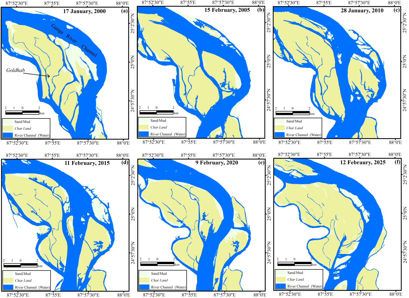
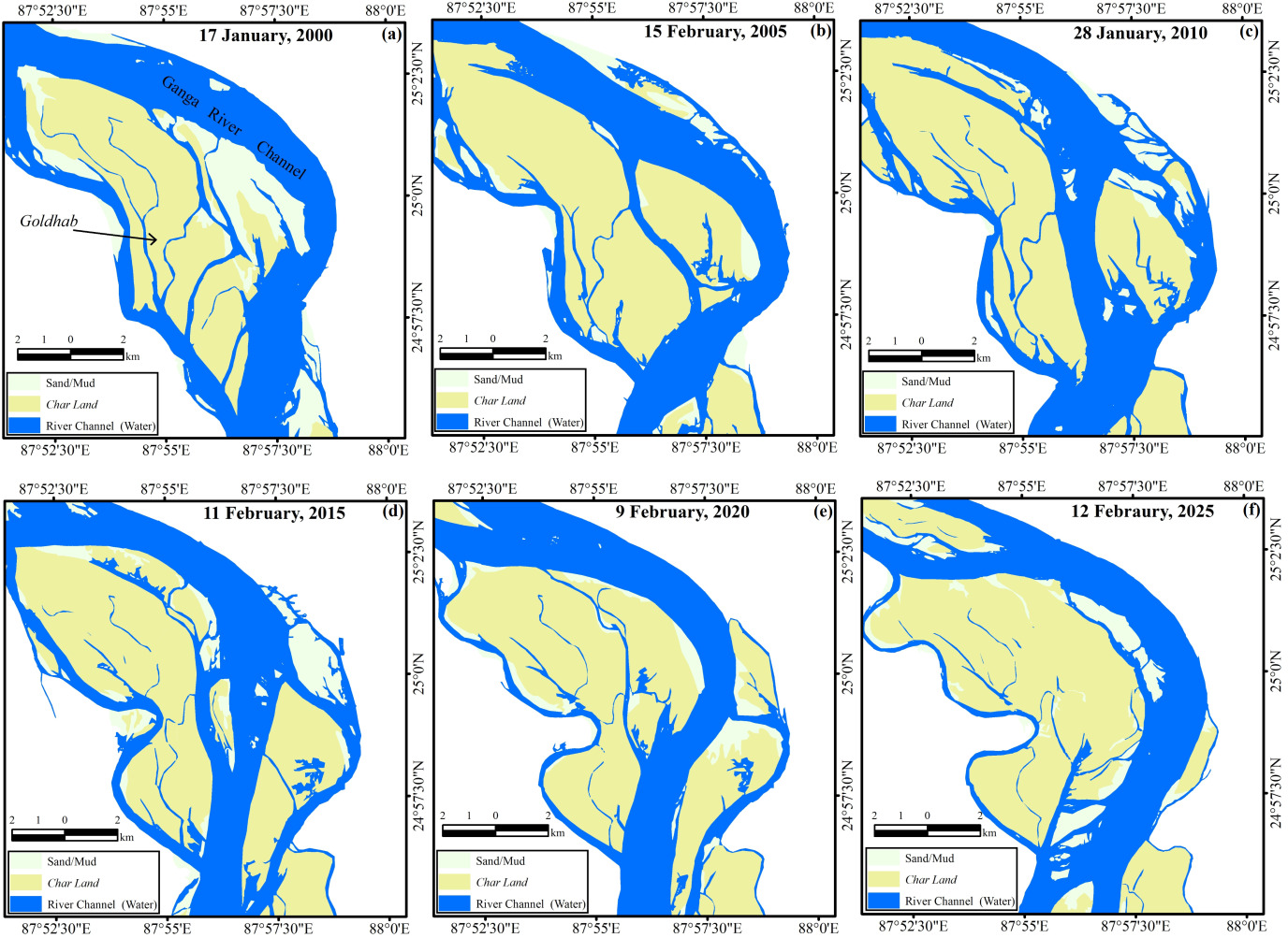
Along the Ganga River, the Goldhab char, is one of the largest stretches of alluvial land in the region (Figure 2a). Following the major floods in 1998 and 1999, the river course began to shift considerably. Consequently, the charland gradually shrank. These changes were evident in the field through the account of a local resident and a daily wage earner, Saiful, who said, “Once, this [Goldhab] was a large landmass. After 2000, as the river’s course changed, the char was divided into two landmasses.” Following Saiful’s account, Figure 2b shows that in 2005, a narrow channel began to form through the middle of the char. It slowly widened and became the main river channel by 2010 (Figure 2c), dividing the char into two parts. Subsequently, as this main channel continued to change its course (Figures 2d & 2e), an extensive stretch of land became visible again by 2025 (Figure 2f). We observed these continuous changes using a spatio-temporal lens with maps or instruments, while also trying to understand them through Saiful’s eyes and memories.
We measured the extent of erosion and accretion of the river channel in Goldhab char along the Ganga River. These measurements provide a quantitative understanding of how the landscape of the char has changed over time. During the periods 2000–2005, 2005–2010, and 2010–2015, the land area eroded was 18.26, 16.47, and 20.05 sq. km, while the extent of accretion was 19.62, 15.75, and 19.85 sq. km, respectively. This indicates that during these periods, the extent of erosion and accretion was more or less similar. However, during the periods 2015–2020 and 2020–2025, the area eroded was 13.58 and 21.20 sq. km, while the extent of land formed through sediment deposition was 20.38 and 25.26 sq. km, respectively. This indicates that the extent of sediment deposition was greater than that of erosion, resulting in the (re)formation of a large portion of the charland. Although we represent these processes in terms of the extent of erosion and accretion occurring across the char area, the people living there express them in terms of how many bighas (traditional unit of measurement) of their land remain submerged under the river and the land in bighas, they cultivate. Nazrul, a farmer from Goldhab, stated that about seven bighas of his land remain submerged under the river, while he cultivates only one bigha of land. Like Nazrul, many char dwellers reported that several bighas of their land remained submerged/lost under the river due to erosion. This loss, however, they reminded, is not permanent and may re-emerge over time as the river entails long-term transformation.
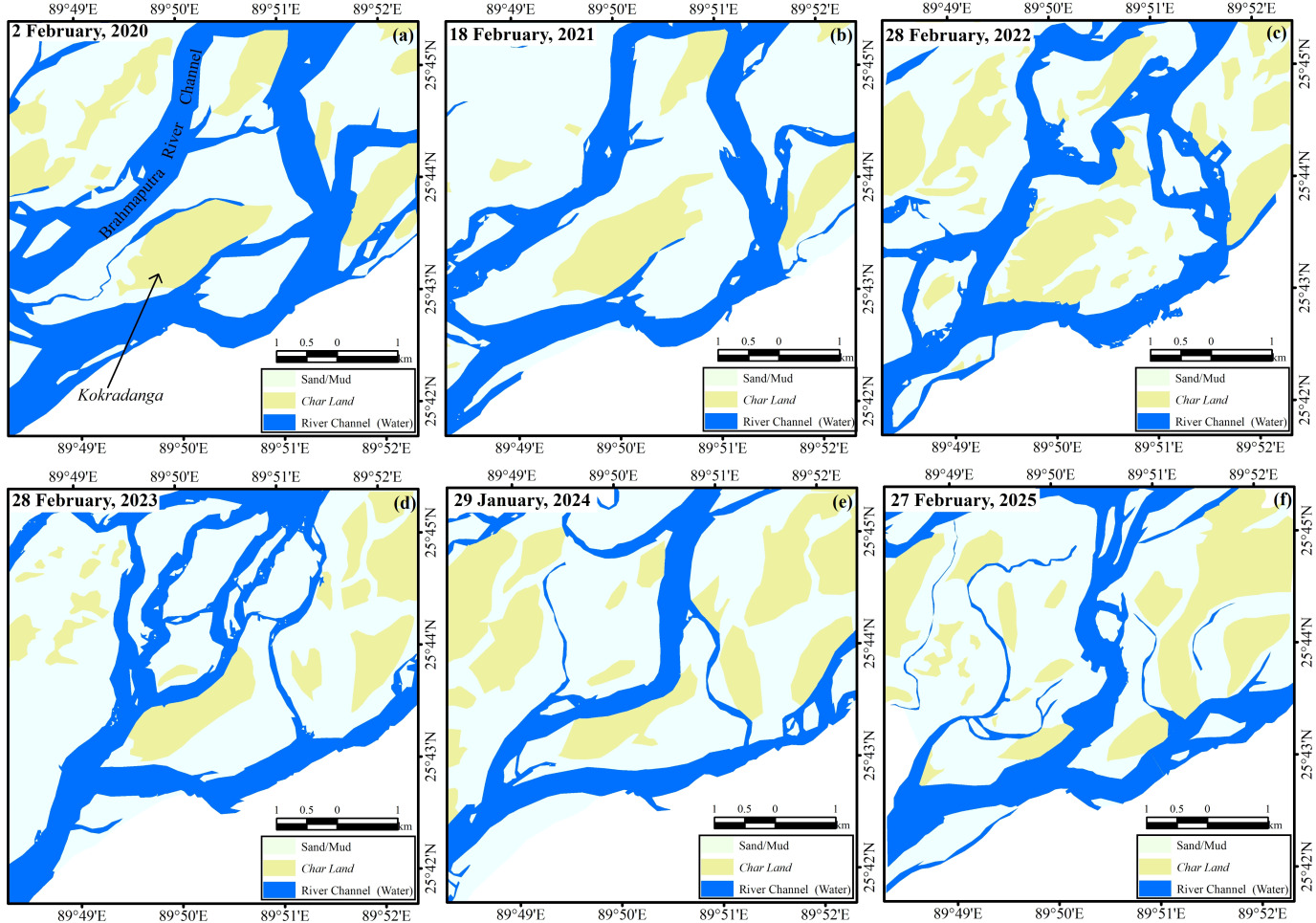
In contrast, charland does not take long to re-emerge in the Brahmaputra River. In 2020, a narrow channel can be observed flowing near Kokradanga char along the Brahmaputra River (Figure 3a). Subsequently, in 2021, the extent of the char increased slightly (Figure 3b). However, in 2022, the river channel shifted towards the char and began to erode the land (Figure 3c). Thereafter, in 2023, a narrow river channel formed and flowed through the middle of the char (Figure 3d). Subsequently, as the channel continued to widen (Figure 3e), it divided the char into two parts. Finally, in 2025, this narrow channel flowing through the middle of the char developed into the main river channel, submerging a large portion of the char under the river water (Figure 3f). Alongside presenting the changing form of Kokradanga char through these figures, we also attempted to understand these changes through the experiences of Abdul, a local businessman, who currently lives in the northern part of the char. He reminded us that a few years ago, due to channel erosion, he had to move southward and lived in his cultivable land. But when that land was submerged by the river, the previously eroded land re-emerged on the northern side, where he is presently located. He has changed his house three times over the past five years. Abdul’s repeated movements clearly show the role of the river channel in shaping the changing landscape of the chars in the region.
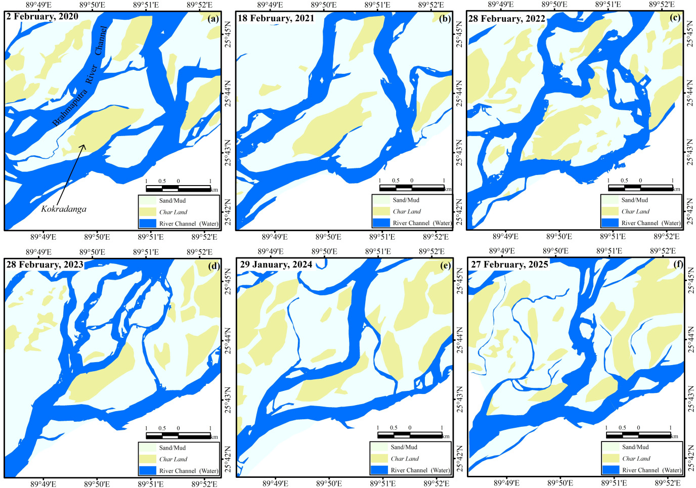
Jafrullah, a cultivator from the same char explained that the processes of erosion and accretion occur rapidly in the Brahmaputra River. He said, “I have a total of four bighas of cultivable land in this char. However, I can never cultivate all four bighas at the same time. A large portion of it often remains submerged in the river water.” Jafrullah’s statement highlights the impact of the continuous processes of river erosion and accretion on the lives of the people living in Kokradanga char. To understand these processes, we measured the extent of erosion and accretion along Kokradanga char. According to our measurements, during 2020–2021, 2021–2022, and 2022–2023, the areas affected by erosion were 0.49, 6.18, and 6.24 sq. km, and by accretion were 5.99, 12.10, and 6.81 sq. km, respectively. However, during 2023–2024 and 2024–2025, the eroded areas were 3.89 and 6.64 sq. km, and the areas of accretion were 12.60 and 4.59 sq. km, respectively. These measures indicate that erosion and accretion in Kokradanga char do not occur in the same pattern. At certain times, the extent of accretion has been greater compared to erosion, while at other times, the process gets reversed. Although these measurements help us with a numerical understanding of these processes, for the people living there, they are embedded in their life experiences, whereby the processes of erosion and accretion become an inseparable part of their lives and their way of becoming ‘amphibious’.
4.3. Becoming amphibious
A recent study highlights that, to understand the complexity of human life in wet environments, it is necessary “to formulate a thorough approach to the amphibious that considers human engagements with shifting aspects of wetness as social, temporal, and material” (Krause et al., 2025, p. 10). Here, the term ‘amphibious’ refers to a form of relationship that is neither land-based nor water-centered; rather it generates its own unique assemblage, reflecting both. It also seeks to emphasize the dynamic and interconnected nature of human-environment interactions that signify life in these environments. Therefore, living in such environments involves an “everyday foray into the interstices of land and water, where creativity resonates with uncertainty amid stories of disaster” (Krause et al., 2025, p. 4).
According to Krause (2017), four key elements are important for understanding such environments: hydrosociality, volatility, wetness, and rhythms. These elements help form the conceptual foundation of ‘amphibious anthropology’ and play an effective role in understanding the complexities of life in river delta areas. People living in these environments also adapt themselves to conditions in which they ‘become amphibious’. They learn to adjust to ongoing transformations of their surroundings and develop adaptive strategies through coping with changing situations (Jensen, 2017). These adaptive practices reveal a social reality of mutual interdependence between humans and their environments, in which the changing nature of chars shapes an amphibious way of life through which char dwellers adapt their everyday lives to the seasonal rhythms of the river.
In the riverine chars, each season brings a new form to their lives, and their lifestyle evolves in harmony with these changing cycles where “water and society make and remake each other over space and time” (Linton & Budds, 2014, p. 170). Through this continuous process of adaptation, they gradually learn to ‘think’ like the river, as formed by the river’s movement and the intertwined labour, thoughts, and adaptations of the people living along its banks (Krause, 2023; Randolph, 2024). This continuous adaptation makes movement, change, and relationships more important than permanence in their everyday lives. As the river flows, the lives of the riparian communities too become part of it, where every movement resonates with the pulse of the river. This continuous flow becomes particularly visible during seasonal changes, when the river reshapes the everyday mobility of char dwellers.
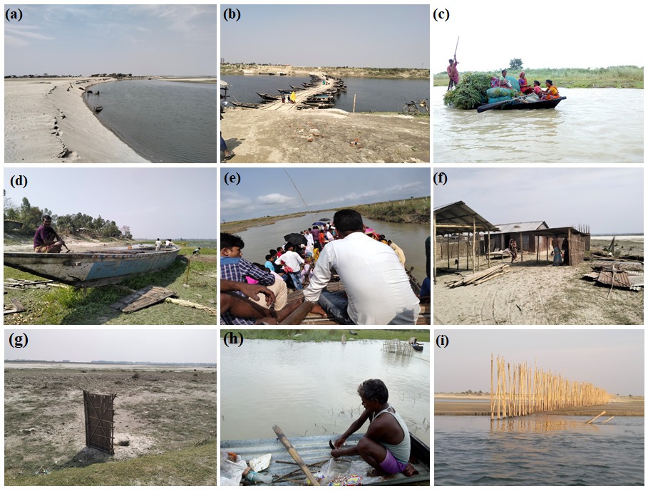
During the dry season, the river dries up and turns into vast stretches of sandbars across its course (Figure 4a). People often walk for hours over these sands to reach nearby destinations. At this time, the river water becomes calm, and residents collectively adopt various innovative ways to bridge the gap between land and water. During a field visit to Bajitpur char along the Ganga (Padma) River, Kamal, a boatman, mentioned, “When the river narrows into channels, boats become almost useless. Instead, during non-monsoon season, particularly in winter, the unused boats are lined up, and bamboo mats are laid across the narrow channels to create pathways.” These temporary pathways (Figure 4b) become part of the communication network in the everyday lives of char dwellers.
However, as the monsoon approaches, this terrain changes dramatically. The same river swells with powerful currents, submerging the chars and reshaping every aspect of life. The boats lying idle for a while now begin to move, becoming the only means of transportation and livelihood during the rainy season (Figure 4c). Between these two contrasting seasons, the char dwellers make every possible effort to reorient their lives. During field visits to Ujirar char, Nazrul, a shopkeeper, explained that he has to travel to the mainland to purchase goods for his shop. Describing his experience of travelling with the seasonal changes of the river, he said, “Our life moves in two ways: borshakale nao aar voralikale pao (by boat during monsoon and on foot during the dry season)”. Nazrul’s words clearly capture the cyclical nature of life in the chars, constantly moving with the changing conditions of land and water.
Char dwellers also prepare themselves in advance for these seasonal changes. During fieldwork at Patamari char along the Brahmaputra River, a few people were repairing their boats (Figure 4d). One of them was Khaleque, who cultivates land during the dry season and earns his livelihood by operating a boat during the monsoon, said, “When the monsoon months arrive, the river water begins to rise, and the char becomes completely inundated. Then these boats become our only means of movement.” However, in many chars, boats are used as the only means of transportation throughout the year (Figure 4e), although their routes change with the seasons. The only way to reach Piarpur char from Pagla ghat near Panchanandapur in Malda district of West Bengal is by travelling along the Ganga River, which has to be crossed by boat. During the journey along this river route, in conversation with Jhontu majhi (boatman), he said, “Our direction of movement depends entirely on the flow of the river, which often varies with the seasons. During the dry season, when the water level is low, we travel through the middle/deeper part of the river, where it is shallow and easier to navigate. But when the monsoon arrives, and the water level rises with stronger currents, we adjust our route through areas where the flow is gentler.”
The direction of their lives, too, is determined by the movement of the river. During field observation at Narukhaki char, Masidur, a labourer, stated, “This year, the river took away all the land where I used to live and cultivate. As a result, we came to live here [some distance from the eroded place]. I know we will have to move elsewhere within two or three years.” Like Masidur, every char dweller knows that even if they settle in one place, it is by no means permanent. However, they build their houses on this temporary land (Figure 4f) and search for a living there. This endless process of change is closely intertwined with the river, as Lahiri-Dutt & Samanta (2013, p. 149) state, “Char dwellers are continually gambling with nature, ‘dancing’ with the changeable moods of the river.” Indeed, the lives of char dwellers are shaped by unique survival strategies and an indomitable will to cope with adversity. Consequently, they learn to live through mobility as the river moves.
The notion of permanence is largely absent from the lives of people living in the char areas, as the ever-changing nature of the river makes any form of stability nearly impossible. Due to such uncertainties, people construct temporary infrastructure (Figure 4g) that can easily be dismantled and rebuilt elsewhere. These temporary structures generally made of bamboo, straw and tin represents a ‘design of impermanence’, a visible expression of human adaptation to the transformative forces of nature. The people living here adapt themselves to an environment where water–society relations exist within the waterscape (Linton & Budds, 2014), continually adapting to and coping with various risks (Baruah, 2022; Sultana, 2010), where they become dependent on water for their livelihoods. Most people living here have fishing as one of their main occupation (Figure 4h). Alongside this, they cultivate crops (e.g., jute) that can grow well in the waterscape environment and serve as an important source of livelihood.
_sand_in_dry_season__b)_pathways_during_the_dry_season__c)_.png)
The livelihoods on char are also dependent on agriculture, which is conditioned by seasonal river flows. During our field observations at Uzangaon char along the Brahmaputra River, we found that floods are understood in two contrasting ways. As Hakim, a cultivator from Uzangaon char, explained, “Small or moderate floods are a blessing for us because they deposit river silt, which increases soil fertility and helps produce better crops in the following season. In contrast, when large or severe floods occur, erosion begins, and crops are destroyed; the fields are inundated, and fertile soil is washed away.” This reflects what James C. Scott (2025) describes in In Praise of Flood: “The flood does almost all the work. It first drowns virtually all the competing vegetation and then, if well behaved, lays down a nutritious layer of fine silt, leaving behind a perfectly harrowed field for the cultivator to sow. The fertile silt in question is, of course, a transfer by erosion of upstream soils” (p. 54). In addition, the types of crops cultivated also change according to the stability of the char. In the early stages of char formation, farmers plant badam (groundnuts) on sandy soils, followed by maskalai (black gram), til (sesame), and sorisha (mustard) as the soil becomes firm and doesn’t require ploughing. Once the land becomes stable and mature, they cultivate dhan (paddy), paat (jute), and sobji (variety of vegetables). The period between July and October is largely unproductive due to flooding, as farmers search for non-farm work or migrate to kayem (settled land), only to return to cultivation after the floods recede.
During this period of continuous flooding and erosion, people living in the char areas make every possible effort to cope with these challenges using various strategies. One effective method is the use of bahor/basher badhoni (bamboo porcupines), as we observed during our field visits to Suk char in the Brahmaputra River (Figure 4i). Our conversation with Rahman, a wage labourer of Suk char, revealed “the porcupine structures are constructed by driving bamboo poles diagonally into the river which acts as barriers when water flows with strong currents.” This structure, collectively built by local residents using traditional knowledge and lived experience, can be easily relocated with changes in water flow/level, reducing immediate threats of erosion. It was observed that, through the participation of the local communities how such challenges are dealt with.
The lives of char dwellers are caught between despair and hope, as the existence of chars remains uncertain. Moreover, they continuously sustain themselves amid various challenges (Cons, 2025). At times, river erosion takes away everything they possess; at other times, the same river returns the land they had lost earlier. This dual reality can be observed in the case of char lands, just as it can be seen in the lives of the people living there. The cycle of losing land and regaining it is situated at the core of their existence. Rather than resisting these changes, they learn to adapt themselves to the pulse of the river; as a result, they become as fluid as the river itself. Over time, this adaptability transforms them into ‘amphibious’ beings, capable of coexisting with land, water and their transformation. It is therefore through an understanding of the adaptive knowledge of char dwellers that we can know the char geographies. It reveals a distinctive relationship between shifting geographies and their amphibious skills of survival.
5. Towards an epistemic approach
South Asian chars are unstable, where the binary between land and water is transcended. To understand chars, we need to move beyond the ideations of fixed geographies. As researchers coming from outside these communities, we also need to reflect on how our understanding of the chars differs from the knowledge developed by those who dwell in impermanence. While spatio-temporal analysis allows us to trace the changing forms of chars, it is simultaneously also important to understand how these changes are interpreted by those who inhabit them. Through our extended fieldwork and periodic interaction with the char dwellers, we learnt about their everyday experiences, how they sustain their lives and livelihoods amidst such shifting geographies. If any one of these dimensions is examined in isolation, the integrated understanding of chars remains less than fulfilling.
In this study, we propose an epistemic approach that brings together the geography, morphology, and anthropological dimensions associated with chars. This approach can be described as a ‘geo-morpho-anthropological’ approach, where ‘geo’ refers to unique geographies of chars, ‘morpho’ to their changing morphology, and ‘anthropological’ to people’s ways of life and adaptations within these changing environments. Thus, while discussing riverine environments such as chars, it is particularly important to integrate these three dimensions simultaneously.
From a geographical perspective, Bhagabati (2001) explains that fluvial islands are primarily formed during floods and their elevation rarely exceeds the highest flood level. Their upstream end is usually steep, while the downstream end is gentler with ripples and larger bedforms. Wyrick & Klingeman (2011), on the other hand, classify river islands in different ways and explain that the hydrodynamic form of an island refers to its planform shape visible above the water surface (subaerial) and classify it into three categories: (a) irregular, (b) angular, and (c) streamlined. They suggest that the shape of an island may also be related to its age. However, their study primarily emphasizes hydrodynamic characteristics and does not factor in the experiences of the dwellers in their analysis.
Cortesi (2025) seeks to minimise this gap by emphasizing the anthropological dimension. Through her study of flood-prone regions of Bihar, she showcases how local communities develop environmental knowledge through their experiences and interpret the landscape through colloquial forms and shapes, such as Aam (mango) and Diya (earthen lamps). It is on the basis of these local experiences and environmental knowledge that Cortesi uses the concept of ‘geomorphoanthropology’ (without hyphens). Her approach provides less space to understand the changing morphology as well as how people sustain their lives and livelihoods and adapt within such environments.
These perspectives highlight different epistemic positions for understanding riverine environments. However, riverine chars cannot be understood through a single perspective alone. In this context, Naveeda Khan (2023, p. 10) argues that no single perspective is sufficient to fully understand the “diverse modes of existence” found in the lives and expressions of chauras (char dwellers). Therefore, ignoring any one perspective may lead to overlooking the realities of chars and their dwellers. For example, char dwellers regularly face various crises related to identity and social recognition (Chakraborty, 2012). This is because when chars are viewed separately from their fluvio-social dynamics, they are labelled as ‘illegal immigrants’ by mainland people particularly in Assam (Momin & Chakraborty, 2024). As a result, an invisible border is created between char dwellers (insiders) and mainland people (outsiders).
We have tried to understand the perspectives of people living in chars in an integrated manner with the surrounding physical elements rather than examining them separately. As the morphological changes in riparian landscapes influence the ways of life of the people living there, the adaptive practices of the dwellers provide an important epistemic intervention for understanding these changing environments. Therefore, rather than interpreting chars only from the position of external observers, we have adopted an inclusive perspective (Box 1) through which the realities of chars can be understood holistically by accommodating several dimensions.
This helps us to reduce the gap between the perspectives of insiders and outsiders. We have emphasized the ‘outsider within’ position, which keeps us connected with the people living there while also allowing us to maintain our position as observers. This is a position that Linda Tuhiwai Smith (1999) refers to in Decolonizing Methodologies as “when in the community (‘in the field’) or when sitting in on research meetings it can feel like inside-out/outside-in research” (p. 5). Therefore, in understanding the environmental and social realities of chars, this position allows us to maintain a relatively neutral or less biased analytical distance as outsiders while remaining closely engaged with the experiences and knowledge of char dwellers.
6. Conclusion
South Asian rivers continuously change through various processes such as flow, erosion, sediment deposition, bed load, etc. Along these river courses, chars emerge through the continuous interaction between land and water. Rather than viewing chars as separate entities of land and water, we consider these elements complementary and conceptualize chars through ‘terraqueous geographies’. We also understand the uncertainty associated with chars and the adaptive practices of their inhabitants as intertwined. This perspective enables us to develop a knowledge system that captures the realities of chars in a more comprehensive manner.
However, the significance of chars cannot be fully understood without bringing them into the field of island studies. Islands are generally understood within this field as distinct and relatively defined landforms surrounded by water. The riverine chars of South Asia, however, challenge this fixed conception and provide an opportunity to rethink islands as dynamic formations. Their inclusion in the field of island studies, however, can enrich the understanding of islandness as a process formed by land–water relationship alongside people’s ways of adapting to shifting geographies.