
1. Introduction
The ferry was the sole mode of public transport within Hong Kong territory from the time of Qing dynasty. Since the late 1970s, however, the role of the ferry in Hong Kong has diminished significantly, thanks to the government’s implementation of a series of large-scale reclamation works, a continuous redistribution of the population, a significant change in travel patterns, rapid expansion in land transit system networks, the development of a public cargo-handling area and the enlargement of extensive supporting infrastructures such as new bridges, strategic highways, and tunnels. In other words, most water-divided cities started to connect islands either by land reclamation or through fixed link infrastructure. Hong Kong’s rapid transformation from a water-based transport network to a road and rail-based metropolis provides valuable insights into how Hong Kong’s Outlying Islands progress over time. To deal with a lack of transport opportunities in the peripheral areas, the ferry system may need to use co-exist with fixed link transport and integrate into waterfront areas (Leung et al., 2017).
Indeed, ferry services still play important roles in providing relief measures during emergencies, such as disruptions to the mass transit railway (MTR) and road closures. In addition, ferry services cater to special demands that do not justify enfranchising certain routes, for example, non-essential services, excursion services (e.g., the ferry taxi connecting Disneyland to the fishing island of Peng Chau and Discovery Bay; ferry services connecting the Kai Tak cruise terminal to other locations) and special services (e.g., vehicular services for dangerous goods vehicles; scattering of cremated ashes at sea). The Hong Kong ferry system is thus able to benefit both regular commuters and the utility of the public transport network.
The introduction of outlying districts ferry services could further contribute to the needs of local recreational areas and facilitate the development of island and wellness tourism. For visitors, ferry services are probably the most recognized symbol of Hong Kong, and the Hong Kong Special Administrative Region (HKSAR) government has extensively used the image of the Hong Kong ferry in overseas promotions. As a result, the continued operation of the ferry system is necessary to maintain Hong Kong’s culture and heritage. Moreover, the possible disappearance of ferry services would adversely affect the islands’ social network connectivity and governance, especially for the sparse populations in peripheral regions.
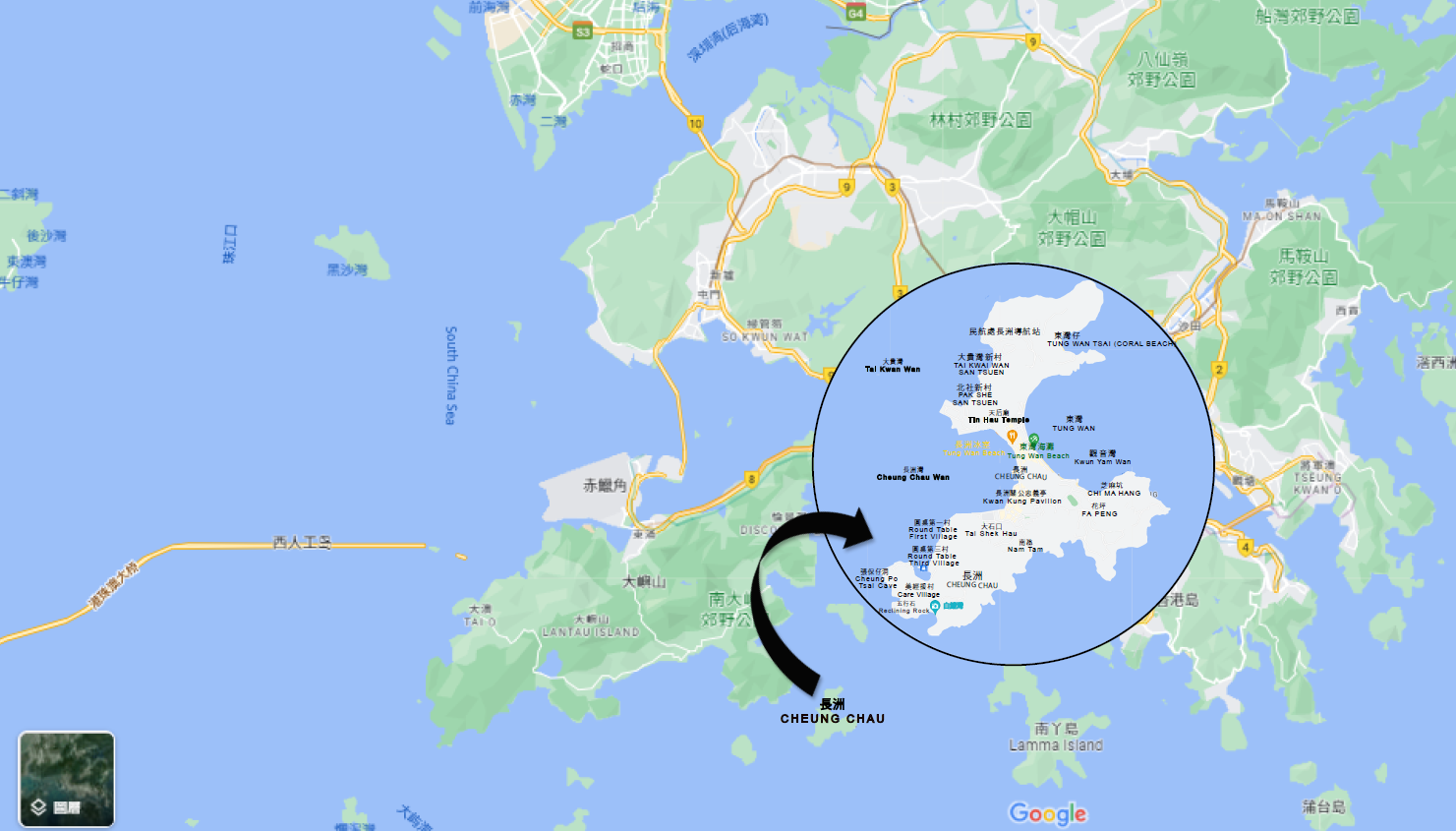
As a research topic, the long history of ferry services in Hong Kong’s public transport sector is important in terms of the sustainable development of inter-island water transport (Choi et al., 1999). Sustainability is defined by the Brundtland Commission (World Commission on Environment and Development, 1987), as “meeting the needs of today’s citizens without prejudicing the ability of future generations to meet their needs.” Hong Kong’s ferry services both provide essential links to Outlying Islands and offer ancillary services between the inner harbour and the new towns. Before the massive development plan connected to the creation of a new airport surrounding in the 1990s, many small Outlying Islands in the vicinity of Lantau Island (e.g., Peng Chau, Cheung Chau, Lamma Island, and Mui Wo) could not foresee the construction of either direct links with the main transportation infrastructure or self-contained town-country units as proposed by Howard Ebenezer’s (1946) early 20th century Garden City plan. The Hong Kong map is provided in Figure 1.
This article looks at Cheung Chau as a case study on how inhabitants depend on ferries. From a geographical perspective, Cheung Chau is located between Lamma (closer to Hong Kong Island and popular among expats) and Mui Wo. Cheung Chau established a leading fishing boat hub and market during the Ming and Qing dynasties. Cheung Chau’s fishing boats benefited from the island’s close access to the Pearl River Estuary. Due to the island’s strong maritime culture and traditions, a shipbuilding industry has emerged (Cheung Chau Magazine, 2022). This makes Cheung Chau a bit different from some of Hong Kong’s other outlying islands because of the greater local vibe and proud traditions.
Although the ferry now only plays a complementary role in providing cross-harbour traffic for Hong Kong as a whole, its major contribution lies in serving the Outlying Islands (M. F. Lai & Lo, 2004; Wang & Lo, 2008). Ferries offer convenient, sometimes indispensable waterborne transportation both for people living in the Outlying Islands and the potential ferry users who could travel a reasonable distance between ferry piers (Ceder, 2006; Wong & Lam, 2006). Of the popular modes of public transport, the ferry is considered to have a low service rate (L. Y. Chan et al., 1999); but people also see that it is the safest means of transportation (Ceder, 2006; Ceder & Sarvi, 2007). It allows Hong Kong residents to live, shop, work, go to school, and enjoy recreation across all the regions of Hong Kong (Meligrana, 1999; Wong & Lam, 2006).
Despite recognising the benefits provided by the ferry system, however, the HKSAR government continues to offer minimal assistance and invests in ferry terminals at a relatively low level (Ceder, 2006). In the past decades, governmental publications, such as ‘Transport in Hong Kong: A paper for public information and discussion’ (1974), the ‘Second comprehensive transport study’ (CTS-2, 1989), the ‘White paper on transport policy’ (1990), and the ‘Consultation document on the third comprehensive transport study’ (CTS-3, 1997), have but demonstrated the Hong Kong government’s lack of support for, and complacent attitude towards, the ferry services. Additionally, the ferry industry itself has received little attention in the literature to date. The studies mentioned above also seem to suffer from a number of methodological shortcomings. Some researchers, such as Chan et al. (2002), Lai and Lo (2004), Tang and Lo (2008), and Wang and Lo (2008), investigated ferry scheduling, service offerings, and network designs only from the angle of operational research. In addition, studies on the Hong Kong ferry system are barely extensive descriptions and analyses of the changing needs of the contemporary business environment (C. W. Chan et al., 2012).
It is clear that a number of important issues related to the ferry services remain unanswered, such as colonial governance, micro-politics of the Outlying Islands, the self-identity of the islanders, and the government’s experiences of controlling the local inhabitants of the Outlying Islands. Understanding such deficiencies, in this study, we shall adopt the concept of centre-periphery theory to explain how ferry services facilitate regional integration of different places of Hong Kong, notably the Outlying Islands, and describe how people are interconnected by ferry services. Even though the Hong Kong ferry has slowly declined since the 1970s, we can see how and why ferry services in Hong Kong are still crucial to keep the city intact and enhance the attachments of peripheral people to the cultural and political centre of the metropolis.
The rest of this paper is as follows. Section 2 provides an overview of the Hong Kong ferry during the colonial period. Section 3 describes the methodology. Section 4 presents the relationships between centre-periphery theory and the Hong Kong ferry. Section 5 uses the case of Cheung Chau to discuss the significance of ferry services in government regime maintenance in remote regions. Section 6 discusses our findings and analyses the island’s socio-economic changes in the past few decades and their interactions with the ferry services. Section 7 concludes this paper with future projections of ferry services for peripheral places in Hong Kong.
2. The current situation of the Hong Kong ferry
Nowadays, most Hongkongers regard the ferry as an essential transportation service. For more than 170 years, ferry services have contributed to various aspects of Hong Kong that pertain to social identity, transport network connectivity, political stability, enhancement of economic development, and fostering tourism development. Indeed, the ferry develops new destinations on remote islands (e.g., Tap Mun) to visit vibrant farming and fishing communities (McKercher & Fu, 2006) in response to quarantine measures and stringent overseas travel restrictions implemented by the government during the COVID-19 pandemic (Lee & Leung, 2022). In principle, the Hong Kong government avoids operating any mode of public transportation directly under official control or paid by the government funds. The established neo-liberal policy believes that public transport services should be run by the private sector in accordance with prudent commercial principles that can help achieve operating efficiency (Searle, 2004). The MTR is an exception and is part-owned by the Hong Kong Government (51% stake), using an all-of-government approach (e.g., urban planning) to aid MTR rail development with value capture of station property development (i.e., rights above ground are sold to developers). But the government also sees a declining trend in water transport, “as there has been little growth in patronage and given the escalating operating costs, the Government has been providing various measures to reduce the operating costs of the ferry services and allow ferry operators to sublet the piers in order to increase non-fare box revenue to cross-subsidize their operations” (Interview with the Transport Department).
Franchises and licenses are the two possible methods that the government may, depending on the circumstances, use to confer operating rights to persons or companies for operating the ferry services. This occurs under Section 6 and Section 28 of the Ferry Services Ordinance (Cap. 104), which allows for the granting of exclusive rights to particular routes. Franchises services are the backbone of the Hong Kong ferry. Under a franchise agreement, the government offers land for ferry piers in tandem (L. W. C. Lai et al., 2011). Licenses are used to regulate most of the local ferry services, including those serving Cheung Chau. As of 30th June 2022, there were 17 ferry operators providing 35 licensed passenger ferry lines to Outlying Islands and across Victoria Harbour. The Commissioner for Transport grants ferry licences for services whose patronage is lower, or they serve localised communities. The licence is valid for a maximum period of three years but could be extended for a further three years at any point in time (Transport Department Hong Kong Government, 1997).
The old ferry operator New World First Ferry Services Ltd has now changed hands, being sold to the Chinese State-run enterprise Chu Kong Shipping Enterprises, which took over the bulk of its passenger fleet (L. W. C. Lai et al., 2011). It has now been rebranded as Sun Ferry. The sale of New World First Ferry Services Ltd. could indicate struggles with profitability and the challenges involved in running ferries in Hong Kong due to the lack of government support and transport policies that neglect ferries.
Additionally, to serve remote coastal settlements, small ferries called ‘kaitos’ provide supplementary ferry services to the peripheral population. Considering the data provided by the Transport Department (2022), we have summarized the service details of franchised and licensed ferry services, as well as the regular kaito ferry services in Table 1.
3. Research materials and issues of discussion
To date, only a handful of historical works have touched upon the development of the ferry in Hong Kong, one of the key elements of public transportation. Some studies have discussed ferries in different regions, for instance, the United Kingdom (Baird, 2012; Cowie, 2012; Laird, 2012; Roueche, 1981), Japan (Baird, 1999), USA (Benenati et al., 1998; Lawson & Weisbrod, 2005), Ireland (Mangan et al., 2002), and New Zealand (Lohmann & Pearce, 2012). Given the historical nature and the study objectives, we carry out a comprehensive review of the government documents collected in the Government Records Service of Hong Kong (www.grs.gov.hk), Cheung Chau Magazine, and 301 legislative council papers (www.legco.gov.hk) published since 1986, dealing with the planning, transportation, economic development and social control of colonial Hong Kong from the early stages to the contemporary times. In addition, we conduct an extensive review of the leading international transport journals and the professional ferry magazines (i.e., the Starstruck Ferry). Finally, we carry out a case study on Cheung Chau Island as follows to explore the island community’s development through the theoretical framework of central place theory, as well as some in-depth interviews with local residents from different walks of life.
In this study, we are outside researchers who depended on past contacts via social or personal networks to access informants adopting snowball sampling. Snowball sampling has been commonly used in qualitative research in various areas of social sciences. This sampling procedure is cumulative which fosters researchers to improve sampling clusters and gives the chance to employ new participants when other contacts have been used up (Noy, 2008). As such, we sought help from the main informants to refer or introduce another appropriate participant during the data collection process. The data collection was carried out from 2020 to 2022. The selected respondents were native inhabitants of Cheung Chau, local residents in Cheung Chau, and key personnel involved in the planning and development of Cheung Chau including government bodies, policymakers, logistics associations, ferry operators, Cheung Chau Rural Committee, and Islands District Council members.
In the ethical approval process, we addressed that details of the interviews would be excluded due to confidentiality agreements. In general, interviews are a typical technique for qualitative research (Ip & Law, 2010). On the positive side, qualitative research generates illustrative and thorough information to understand the different dimensions of the problem under analysis and obtain insider insights into the research’s objects. On the negative side, researchers have difficulty obtaining precise and concise conclusions. As such, research results are unquestionably influenced by the researchers’ own interpretation. Also, researchers require deep knowledge of the problem domain (Queiros et al., 2017; Tuli, 2010).
4. Central place theory and studies concerning the Hong Kong Ferry
In this section, we employ the central place theory, or the Centre-Periphery theory, to consider the roles of the ferry service in connecting a territory with natural barriers such as mountains and water. Broadly speaking, we define the centre as the core area of a region, and the periphery as its dependent and subordinate areas. The centre and the periphery refer to various levels of spatial organization ranging from the global level of intercontinental relations to the local level of an internal structure of a given country’s regions or other smaller territorial units (Zarycki, 2007). The centre designs the organization and controls the subsidiaries, i.e., the periphery (Forsgren, 1990). According to Galtung (1971), the centre plays decision models and provides ideas, norms, visions, and ideals whereas the periphery plays obedience models and provides imitation and adherence.
In this regard, Christaller (1933) and Lösch (1944) first applied the central place theory to urban geographical studies in the 1930s and 1940s. Christaller (1933) illustrated the central place theory in agrarian societies, and the theory anticipated the emergence of a hierarchy of settlements, with each level of the hierarchy achieving corresponding levels of development and providing distinctive services. In the landscape, the economic activities of people relative to specific central places at each hierarchical level in accordance with the services provided, including central towns for cooking utensils, a nearby market town for items of daily use, metropolises for specialized services (i.e., higher education), and cities for the fashionable clothes. It establishes a significant starting point for an investigation of social patterns under a central place analysis.
To search for evidence to support the ‘market’ and ‘traffic’ variants of Christaller’s central place theory, the celebrated anthropologist G. William Skinner applied the central place analysis to analyse the spatial structure of rural Chinese society (Qi et al., 2004). Skinner argues that a given society should have a centre, and the centre zone has a definite location within the bounded territory. Some people will be a bit closer to the centre, while some will be more distant from it (Shils, 1961). In the structure of a society, the centre, with all the advanced infrastructures and services, is geographically more centrally located in the interaction networks than the periphery (Lehtonen, 2011). The literature on central place theory appears widely in the fields of urban studies (e.g., Chase-Dunn & Hall, 1991; Copus, 2001; Krugman, 1991; McLoughlin, 1994; Wallerstein, 1991); tourism studies (e.g., Getz, 1994; Keller, 1980); and in the economic, political or cultural dimensions of spatial relationships (e.g., Forsgren, 1990; Krugman, 1991; Lehtonen, 2011; Wagner & Leydesdorff, 2005; Zarycki, 2007). The central place theory is a suitable analytical tool for our study of the outlying areas of Hong Kong, as we may see the urban area as centre and the rural area as the periphery (Lehtonen, 2011), particularly during the earlier stages of economic development in colonial times when satellite towns were yet to be well established.
Geographically, the former British colony of Hong Kong is a political region consisting of Hong Kong Island, Kowloon Peninsula, and the New Territories separated from Mainland China by the Shenzhen River, Lantau Island, and 262 Outlying Islands. It is located at 22° 15’ 0" N / 114° 10’ 0" E and covers an area of 1,104 km2. Between Kowloon Peninsula and Hong Kong Island lies Victoria Harbour, widely recognized as one of the most favourably located deep-water harbours in Asia. Since Hong Kong is situated at the south of the Tropic of Cancer, it has a humid subtropical climate with temperatures seldom dropping below 10° C in winter, so that the port is never frozen, and exceeds 31° C in summer. It is in general warm, sunny and dry in autumn, cool and dry in winter, and hot, humid, and rainy from spring to summer (GovHK, 2021).
Historically, we consider the beginning of Hong Kong society in light of human presence in the Chek Lap Kok from 35,000 to 39,000 years ago or, more conservatively, on the Sai Kung Peninsula in the mainland 6,000 years ago. In the Western Han Dynasty (206 BC–AD 8), there were inhabitants in Ma Wan Island as Punti (i.e., local) settlement. Later on, China’s fleeing imperial court found refuge in Silvermine Bay on Lantau Island during the Battle of Yamen (1075), fighting the advancing Mongols by the end of the Song Dynasty (960–1279). In 1513 during the Ming Dynasty (1368–1644), the Portuguese adventurer Jorge Álvares arrived in Tuen Mun, but failed to establish a settlement there, and was instead eventually allowed to stay in Macau located on the opposite side of the Pearl River Mouth. In 1661, the Qing court (1644–1911) implemented the ‘Great Clearance Policy’ that forced the evacuation of the coastal areas of South China. This harsh measure destroyed the earlier maritime communities and made Hong Kong largely a wasteland (C. W. Chan et al., 2012; Tsang, 1995). During this evacuation period, almost no people settled in the area within 25 km from the coast, so there was small demand for transport of any kind in Hong Kong. Prior to 1842 when the British acquired the Hong Kong Island after the Opium War, the majority of Chinese settlers in the region of today’s Hong Kong were living in the North-Western region of the New Territories, the areas of Stanley, Aberdeen, and Shau Kei Wan of the Hong Kong Island. There were only 7,450 people living on Hong Kong Island according to the first colonial census. Between 1842 and 1997, Hong Kong was a crown colony of the British Empire, governed by a governor sent from London.
The British government’s large-scale urban construction attracted many people to work and settle down on Hong Kong Island, and other areas when the colony expanded. By 1914, the population of Hong Kong had reached 501,304. Thereafter the population steadily increased, except during the Japanese occupation in the early 1940s (Tsai, 2000). When the Japanese surrendered in 1945, the British retook Hong Kong, disregarding opposition from China’s Nationalist government, for strategic reasons; most significantly, having proximity to Victoria Harbour, Hong Kong Island’s Central district housed major military facilities and played the role of administrative centre from the first day of British rule. Under the shadow of the sentiment of the Chinese government to take back Hong Kong, it became crucial for the British to establish useful connections from Central to other peripheral areas of the colony.
Meanwhile, Civil War broke out in China, and this political development prompted Chinese people to flee the mainland and relocate to Hong Kong. The population significantly increased from 600,000 in 1946 to 1,750,000 in 1948 (C. W. Chan et al., 2012). Since then, Hong Kong has experienced a rapid economic boom and urbanization. It was a challenge for the colonial government to develop the peripheral areas to accommodate the immigrants, and thus it needed to install local transportation means to link land and water. The population in 2014 was 7.26 million, which was more than double that of the 3.13 million who lived in Hong Kong in 1961. For the coming few decades, the HKSAR government foresees that the population will continue to increase at a fast pace (Census and Statistics Department, 2015), so the metropolis will need more infrastructure to connect with the new urban areas.
During the rapid post-WWII development, Hong Kong’s Outlying Islands have become geographically more peripheral and disadvantaged (Keller, 1980). Although some Outlying Islands such as Cheung Chau have magnificent pre-colonial towns and flourishing villages (see next section), many islands are sparsely inhabited and remain largely rural. Cheung Chau and other Outlying Islands functioned more independently, with their own higher-order services as cross-district travel was expensive and time-consuming. For example, there were formerly two cinemas in Cheung Chau (Cheung Chau Magazine, 2022). This creates a vicious cycle, as the lower social classes tend to ignore the symbolic world of the centre (Zarycki, 2007). Improved transport made these ‘higher-order’ services go out of business in the early 1990s. In this sense, the Hong Kong ferry services are significant for keeping the city intact between the centre and the periphery. They have been indispensable for the Hong Kong government to maintain and even improve the islanders’ economic and social well-being.
5. Cheung Chau: A case study
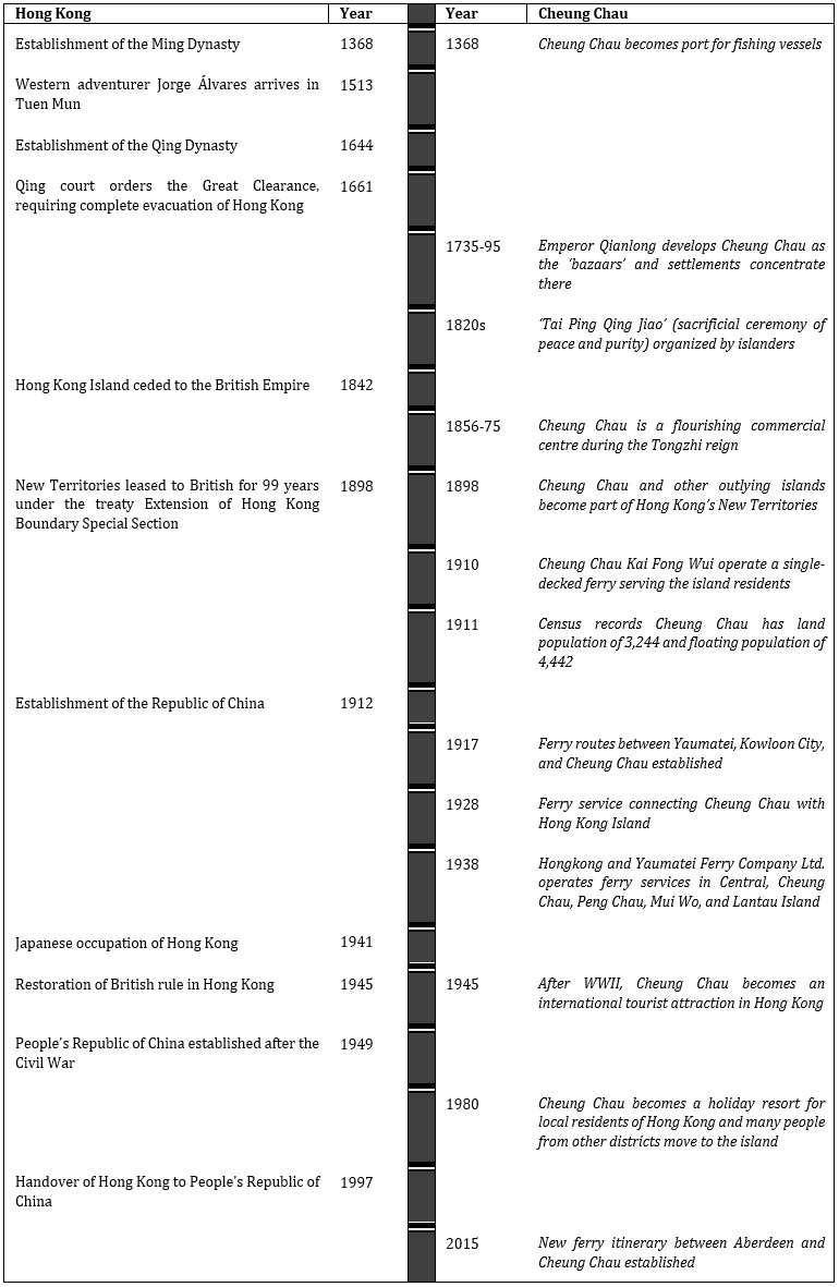
Cheung Chau is the longest continuously existing inhabited area in Hong Kong. Geographically, Cheung Chau is a small island located just over 8 km west-southwest of Green Island at the western end of Victoria Harbour (Hayes, 1962). It is located to the southeast of Lantau Island, at the north side of Hei Ling Chau and the southwest side of Shek Kwu Chau. The island is dumbbell-shaped, with hills at the northern and southern ends. Moreover, this island settlement was not isolated, as many of the relatives of the Cheung Chau residents were living in Aberdeen on Hong Kong Island. During the late 20th century, thanks to kinship connections, after abandoning their fishing boats, the islanders employed the ferry “to get married, to visit graves outside, to move house from island to island, to deliver necessities and food, and to enjoy a vacation” (Interview with local residents). To exhibit the historical study of Cheung Chau and how it interacts with the rest of Hong Kong, the timeline of the historical development of Cheung Chau Island is provided in Figure 2.
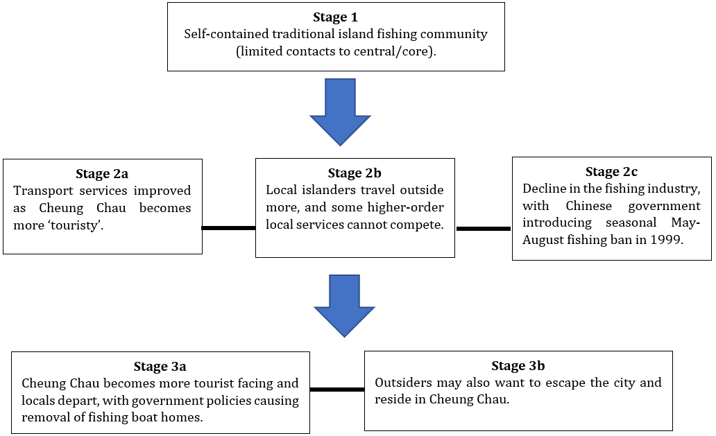
Since the 1980s, Cheung Chau has been further developed into a holiday resort for lower-middle class and young people of Hong Kong society, and the fishery has become a marginal industry in the local economy. Under the impact of emerging tourism, therefore, Cheung Chau has experienced typical demographic changes from a traditional fishing village to a resort-like residential area of mainly non-native residents. At the same time, the island has witnessed the outmigration of young natives who experienced unprecedented interactions with the outside world (Chew, 2009). Indeed, the emergence of the peripheral tourism industry has brought significant potential for economic development, and many people from other parts of Hong Kong have been attracted to live on this vibrant island. Cheung Chau’s local windsurfer Lee Lai Shan won Hong Kong’s historic first Olympic gold medal in 1996, further putting the island into the spotlight (also helped by the local cartoon ‘My Life as McDull’ featuring Cheung Chau’s ‘Tai Ping Qing Jiao’ bun festival and Lee’s windsurfing), which may have helped the locals to lobby for more funds for transport and community infrastructure. The ‘Tai Ping Qing Jiao’ was reinstated in 2005 (prohibited in 1978 due to a collapsing ‘bun mountain’ scaffolding causing 24 injuries).
Another point to note was the Rural Committees (and the Heung Yee Kuk) have increased relative powers since the handover as they now hold some guaranteed seats in District Councils, the Legislative Council, and the Election Committee (that elects the Chief Executive). Another point to note is that during the Asian Financial Crisis and the 2003 SARS epidemic, the beach houses in Cheung Chau became a popular spot for people to commit suicide by burning charcoal in window-shut houses. Nevertheless, visitor suicides have a remarkable effect on Cheung Chau residents due to a connected and small community (Yip et al., 2022). Starting from 2004, the ‘Tai Ping Qing Jiao’ festival has been attracting between 40,000 and 50,000 international and domestic tourists to visit Cheung Chau Island during the ceremony. The key progress of social changes in Cheung Chau is summarized in Figure 3.

It is recognized that the increasing demands for travel to Cheung Chau require more ferry services, but institutional limitations are imposed on private initiatives. Fully understanding the importance of the ferry in the governance of the outlying island, the reins of water traffic development have been firmly held in the hands of the government. The Licensing and Port Formalities of the Marine Department explained the procedure for the ferry operators or community associations of different rural places to propose new itinerary maps or revised ferry schedules to the Transport Department:
All the ferry operations within Hong Kong waters need to get the permission prior from the Transport Department. After that, ferry operators should apply for Approval in Principle Letter for Certification and Licensing of a Local Vessel. The Marine Department then will inspect their ferries to see if they could meet the international safety standard. The whole processing time is 21 days. The procedure has remained the same from the past to now.
This complex system makes it difficult to change routes or increase ferry frequency.
6. Major findings
In late 2017, we conducted a series of 26 in-depth, face-to-face, semi-structured interviews with three main types of people, namely representatives from the ferry companies, transport associations, and government officials of different departments handling Cheung Chau affairs; native islanders staying in their home place; and the immigrants who have moved into Cheung Chau over the past few decades. The details of the interviews were excluded due to confidentiality agreements. In the following, before inquiring about the situation of the newcomers, we first discuss the findings of the native islanders’ reasons to stick to their homes and, more importantly, their experiences with the changes in ferry services over time.
Our interviews with the native residents who decided not to move away from Cheung Chau found that the main reason for staying is financial: rental prices on the island are relatively cheaper than the centre urban areas. The island has provided integrated infrastructure, such as hospitals, government schools, a rural committee, and graveyards that could serve a person’s needs over the course of their whole life. Moreover, the emotional bond to the place is another important pull element for the decision, as the natives consider themselves ‘indigenous people’ living with lifelong friends who work as teammates in the fishery that supported the island since ancient times. They are proud of the traditional heritage of maritime culture. Socially, the islanders have a strong sense of local identity and unity. They are organized in different associations to connect and cooperate with each other for their local agenda. In addition, for the elderly residents, the Islands District Council regularly distributes necessities like food and drinks, and this benefit increases their motivation to stay on their home island after retirement.
The relatively strong social ties of the islanders contributes to the unique educational arrangement for this community. Due to the relatively small population size, the native residents mostly attend the same set of schools from kindergarten up to the secondary school level. The school-goers usually work part-time on the island. They only need to leave the place to pursue higher education outside, but some of the island’s university graduates have even chosen to return to Cheung Chau for jobs or residence. In sum, most islanders are alumni from the same set of schools.
We have interviewed the staff of the Cheung Chau Secondary School and found that about 80% of their students are residents of Cheung Chau, and the rest are coming from the nearby island Peng Chau. As for teachers, most of them are not Cheung Chau residents. They are working on the island because the teacher job market outside is too competitive, so they have no choice but to commute from the town. To provide convenience to the urban teachers, the school has adjusted its timetable to have the first lesson at 08:45 a.m., almost an hour later than normal schools in the urban centres. From the school’s point of view, the ferry provides a convenient transport mode between Cheung Chau and Peng Chau, which contributes an important source of students, and facilitates the students’ mobility to participate in different learning activities in town, not to mention the necessary connection of teachers from the urban centres.
In fact, after graduation from secondary school, many native islanders continue to work on the island, while some work in urban centres, such as Central and Wan Chai, but are only commuters, going from the island on the weekdays. As emphasized by the interviewees, their choice of jobs is largely based on the easy accessibility to travel from and to Cheung Chau. Ferry services have become critical to their livelihoods and career development if they are staying, so the islanders have been advocating for the improvement of their maritime public transport in the due course of Cheung Chau’s development during the past few decades. The strong identity of the place is not a result of isolation, but a reasonable connection facilitated by the daily maintenance of the community.
The officials from the Social Welfare Department of Hong Kong recognized that the ferry services have helped maintain government control in this outlying island and has also provided a fast and convenient transportation mode to other areas to deliver the materials and necessities for emergency purposes. Different types of ferries also help Cheung Chau to be more self-contained, as the large retailers like Wellcome, Park’n Shop, and 759 opened branch stores on the island, and they employ the kaito to deliver commodities from Western District to Cheung Chau. At the same time, other small food shops and retailers use the slow-speed licensed ferry to deliver fruit, food, drinks, and vegetables from their Hong Kong Island suppliers to Cheung Chau. It is not necessary for the islanders to head for the central urban areas for groceries and other basic daily supplies.
The ferry service of Cheung Chau, however, had some deep-rooted problems during the colonial era. According to interviews with native residents, before the 1990s, there was only a slow-speed ferry service linking Cheung Chau to the urban centre, and the latest departure from Central to Cheung Chau was at 23:30. If the residents missed the last ferry, they had no choice but to stay in the urban area overnight, probably asking relatives or friends downtown for a bed. This was extremely inconvenient to the daily life of residents, especially those youngsters who needed to work and have a social life in the urban centres. Yet, their more serious trouble was not occasionally missing the last ferry but instead undertaking the daily navigation itself. At the time, the ferries had not yet installed advanced navigation equipment and technologies such as radar; they relied solely on primitive means such as a horn to alert incoming vessels on foggy days, to prevent collisions, which were fairly frequent. A commute of around 20 km over the sea could last two hours. Incidentally, to seize the chance to earn extra income on such a long journey, the ferry operators installed refreshment kiosks to provide their passengers with food and drinks, but at a price more than 30% higher than offboard restaurants, though most Cheung Chau residents enjoyed the breakfast during their prolonged ferry trip.
Besides the slow speed of navigation, another structural shortcoming for the commuters of Cheung Chau was the multi-stop inbound arrangement of the ferry operator. On weekdays, there were few direct return ferries departing from the Central Pier. Commuters usually needed to ride on the inter-island route that stopped at Chi Ma Wan first, then at Mui Wo (both piers located on the massive nearby Lantau Island), then at Peng Chau, before finally arriving at its terminus at Cheung Chau. The total sailing time of the whole trip was around 1.5 hours, and this was far from the ideal daily experience for a weary Cheung Chau resident heading for dinner at home.
With the effect of Cheung Chau’s local windsurfer Lee Lai Shan, the Cheung Chau ferry services significantly improved in 1997. The native residents appreciated that nowadays the ferry schedule has become more frequent, and the input of a smaller high-speed ferry for 105 passengers, which is air-conditioned and more comfortable, has shortened the travel time for the commuters from about an hour to 30 minutes, and the ship operation is relatively stable and safer thanks to the installation of new navigation technologies. The ferry has also provided an overnight schedule to fit late commuters. On top of that, the traditional lower-speed, three-level ferries have been changed to four-level which have the capacity for 1,500 passengers, to accommodate the growing travel needs of tourism.
The Social Welfare Department also recognized that the improvement of the sailing schedule, as compared to the old ones in the 1980s, has helped them to significantly improve the social welfare service to the island community. A small regret of the speedier trip may be found in the removal of the beloved refreshment kiosks on deck, as a result of the competition of convenience stores and fast-food stalls on the pier providing a variety of cheap food for the hungry commuters. Since the start of the 21st century, the frequency of the ferry schedule of Cheung Chau and the scope of overall ferry services have been further improved over time. For instance, Tsui Wah Ferry’s Maris Ferry has provided a new ferry itinerary between Aberdeen and Cheung Chau since 8 August 2015. This new route gives more direct access to the Southern District of Hong Kong, arguably reestablishing the traditional link between the two fishing villages. Moreover, travellers asking for cheaper fares and a longer experience, about 50 minutes, to enjoy the natural environment at sea, could still choose the less frequent traditional slow-speed ferry.
The improvement is by no means free, however, and residents have to pay the cost. As the licensed Cheung Chau ferry service was then a monopoly arranged by the government, the native residents complained that in the past 30 years the service has become comparatively expensive, and the attitude of the ferry staff have often been unpleasant. Moreover, the pier and boat facilities used to be poorly maintained and their hygiene was usually questionable. For example, some toilets on board were broken and without regular maintenance, and the piers were dirty and with no air-conditioning. Indeed, the most important problem with the Cheung Chau ferry was its unpredictable schedule, particularly the so-called ‘additional ferry’ that catered to the extra travel needs of tourists on special occasions. More importantly, since the reintroduction of the ‘Tai Ping Qing Jiao’ bun festival in 2005, hundreds of thousands of tourists have flocked to Cheung Chau every year during this carnival. The capacity of the Cheung Chau ferry has thus been seriously challenged. As observed by the ferry operators, during the 2010s, there were about 20,000 to 30,000 passengers using the ferry daily over the weekend. The ferry schedule was in 15-minute intervals, and there were around 80 sailings between Cheung Chau and other areas. On average, the Cheung Chau ferry received 10,000 users per day.
Indeed, more generally, the great differences in passenger sizes between the weekdays and weekends have imposed great disturbances to the daily transportation needs of the locals, as they need to wait for no less than an hour for their ferry on the seasonal peak dates. As such, it might be better for Hong Kong to consolidate all ferry services into one company (and quasi-government owned like MTR). Then we can have a larger fleet and adjust according to different areas’ seasonal/temporal patterns. This is probably costly in the first instance but more cost-effective in the long run. We can even use the ferry to work with MTR stations and to reduce crowdedness in post-COVID considerations.
From an economic point of view, thanks to the development of tourism, there are more job opportunities inside Cheung Chau for native residents, so they have new choices for not working outside the island. Their complaints about the overcrowded water traffic notwithstanding, the inflow of investment of capital, both governmental and private, from the centre to this peripheral place is widely perceived as a means to enhance the overall welfare of the Cheung Chau population (Keller, 1980).
The bulk of Cheung Chau contains village-type development (V-zone) (Town Planning Board, 2022). Village-type developments are only granted for native-inhabited areas before the 1842 British extension to New Territory. A particular feature is the ‘Small House Policy’, which grants native male villagers special rights to obtain land for a three-storey ‘small house’ but with limited transferability in the property market (although illegal land deals are rampant). This is probably why some native villagers stayed on, and the housing market in Cheung Chau has lower property values. The improved economic condition, however, is a pull factor to attract immigrants from other districts of Hong Kong to move into the island community of Cheung Chau. Moreover, because of the shortage of residential land, the Hong Kong government had built public housing on the island. The Cheung Kwai Estate and Nga Ning Court were established in the 1980s and 2000s. Such housing is primarily for non-natives.
Many of those new residents are not Cheung Chau-based, so the ferry is a necessary means to connect them to urban life. As public housing was introduced by the government, it is natural for the people to perceive that it is the government’s responsibility to take care of the transportation needs of the newcomers. We interviewed five non-native residents who moved to the island during the past two decades to learn about their reasons for, and experiences of, living on this peripheral island. Table 2 shows their occupational changes before and after their move.
The main reason behind their relocation is again financial consideration, as the house rental prices on the island are cheaper than in central districts. This is not unlike the pull factor to attract native islanders to stay in their home place. They are not total strangers to the place, as some had relatives who had already moved to Cheung Chau, and some married locals and chose to stay. Their relocations are also inspired by cultural and religious motivations; most of them appreciate the traditions and customs of the islanders.
As for the ferry experience, the immigrants generally shared the appreciation and complaints of the native islanders, but they especially pinpointed the problem of onboard announcements being too long and annoying. They also found that the introduction of an elderly passenger travelling subsidiary (HKD 2 per trip) since 2012 has invited more and more tourists to use the Cheung Chau ferry, which has been largely overcrowded, so that residents could hardly get on the scheduled ferries. Worse still, this scheme has caused more travellers to visit Cheung Chau during weekends and holidays, so the residents have no choice but to wait much longer for their necessary water trips. To counter the crowded ferry, the immigrants suggested that the government should provide exit permits for priority trips by Cheung Chau residents, or quotas of entry certificates for tourists.
In addition to the aforementioned socio-economic reasons, the environmental benefits of Cheung Chau over the central regions is another subtle pull factor for people choosing to stay on the island. Although Cheung Chau has absorbed thousands of immigrants from urban districts, both the natives and the new immigrants still regard Cheung Chau as an ideal residential area relatively less crowded than other urban centres. Indeed, Hongkongers generally see Cheung Chau as a green area of the metropolis, as the immigrants generally feel that the better air and water of this peripheral island contributed to good quality of life. To keep the place peaceful, the government prohibited cars and other vehicles on the island’s narrow streets, save for some miniature fire engines operated by the Fire Services Department. The only means of rapid transport are bicycles.
The improved economy of the island and better connectivity of the ferry have not necessarily created one-sided pull effects. In fact, some natives chose to leave Cheung Chau due to the island’s tourism boom. We conducted interviews with four residents who left Cheung Chau for the central urban area in the past few decades and learned the reasons for their moves. Table 3 shows the occupational changes of our interviewees.
From the experiences of our contributors, we see no significant contributions of moving to urban areas to their social upwards mobility. In other words, they have left Cheung Chau not for a better job or a higher salary, but for a change in mode of life. They still weighed that living in Cheung Chau has advantages such as the unique culture of harmony, closer community networks, good environment, good restaurants, and abundant space for leisure activities. These perceptions are not too different from those of their fellow islanders staying behind. The reasons they left are not the disadvantages of the place, but personal issues, such as marriage, or the government’s offer of public housing in the urban area that outweighed the low rental prices of Cheung Chau. They had complaints like the flooding in of tourists that pushed up the price of their restaurants, but generally, they admire their native island as before. As for the ferry services, our interviewees had similar complaints and made the same recommendations as did immigrants, namely, that the government should issue a resident pass for the Cheung Chau residents, to give them top priority to get onboard. Some also suggested that the ferry operator could arrange a slow-speed ferry during the peak hour, to reduce the transportation cost for residents not in a hurry.
To summarize the experiences of different types of residents of Cheung Chau, without the ferry services, it is impossible to develop large-scale tourism in this water-based area, and the non-fishing residents of the island could hardly settle on the island as commuters. Ferries support the development of tourism and promote the intangible cultural heritage of Cheung Chau. Nonetheless, our interviewees might have little knowledge about the serious financial burdens of maintaining a good ferry service. Indeed, ferry operators have been facing such severe deficits in their operations that they may eventually close their services, as has occurred in other peripheral areas. Fortunately, the HKSAR government decided to support this ferry link by providing HKD 3.52 million in subsidies to New World Ferry for the Cheung Chau-Central route, mainly to support the children’s concession fare (Cheung Chau Magazine, 2022). Recently, some policymakers even argued that as Cheung Chau residents generally enjoy lower property prices, from the perspective of impoverished people from other districts, the islanders should enjoy less transport subsidies from the public funds. The bottom line is that the HKSAR government understands that the ferry services are indispensable to the connection between this populous yet peripheral island and the rest of the region, so it must keep the basic infrastructure of public transport to connect the island population to the urban central areas.
7. Conclusion
The ferry is the oldest public transportation means in Hong Kong and has been developed for over 170 years. It connected different parts of the region, and therefore became an essential element of the Hong Kong government to maintain effective control over the scattered areas of Hong Kong separated by water. Before the 1970s, the ferry system was the foundation of public transport and the sole mass transport mode in Hong Kong. The establishment of harbour-crossing tunnels and railways, however, were watersheds in ferry development. Indeed, the ferry has then been reduced to a supplementary, if not recreational, means of mainstream land-based transport after the 1970s. Clearly, the government imposes the current neglect of ferry services and inclines toward a land and rail-based transport policy in the design and implementation of an integrated transport and urban planning model.
Although the Hong Kong ferry services have been gradually declining for the past half century but still play a significant role in keeping the city intact, notwithstanding the financial hardships of deficits. According to the analytical model of central place theory, better transportation may undermine the peripheral place and cause resources and people to concentrate in the centre. The limitation of size and isolation in water also hindered Cheung Chau from being absorbed into the central region of Hong Kong. Its fate is to be the periphery of a well-developed city.
This study elaborated upon the important central place theory of spatial structure and order, required in the study of transport geography, economics, and island cities. The central place theory tries to explain the spatial distributions and interdependencies in Hong Kong and offers opportunities for a new typology of island communities according to the absence or existence of fixed links. To a certain extent, this study could be expanded to other similar cities which are connected by either fixed links or ferries. As reflected by our interviews, however, the improved ferry services of Cheung Chau have not pushed the native people to move to the urban centres; instead, they have enhanced the identity of the outlying peripheral residents as members of their own island community, although their dependence on the centre has rapidly increased. They may work as commuters in town but plant their roots deeper on the island. Indeed, the waterborne Cheung Chau is a good example of a controlled area experiencing transformation from a traditional fishing village to an island resort that attracts new non-local residents, while at the same time losing its young natives because of outmigration. Yet the effect of the ferry is more favourable to the island, as the speedy and 24-hour connection empowers the younger generation to stay and live in Cheung Chau. In addition, local identity is dually strengthened by the heightened attention of the tourist flocking to the island on vacation to see the culture of this historic island as well as the symbolic and essential ferry connection between Cheung Chau and the urban centre of the metropolis (Chew, 2009). In short, good ferry service nurtures a win-win situation for the centre and the periphery.
The continual development of local tourism will undoubtedly fuel the improvement of the ferry service of Cheung Chau over time, but whether this trend will improve convenience for the local population’s general livelihoods and transportation needs is still questionable. As the locals are no longer the ferry operators’ most important passenger group, local needs will be satisfied only after those of the day-trippers. The Cheung Chau Rural Committee and some policymakers see market competition as the key to balanced development. They propose water taxis as an alternative to ferry services, especially during late-night and off-peak hours. This on-demand service could be consolidated through centralized operations, with licenses issued by the government. Finally, the possibility that the government may build a bridge linking Cheung Chau with the Lantau Island in the future ‘Lantau Tomorrow Vision’ could be a development that totally upends the Cheung Chau community network and the central place relationship.
To the best of the authors’ knowledge, Cheung Chau has the largest population of all Hong Kong’s Outlying Islands. Also, Cheung Chau is one of the major business hubs and one of the most popular travel destinations in Asia (Ip & Law, 2010). Law and Ng (2011) also highlight that Cheung Chau is identified as one of the most attractive and popular Outlying Islands by visitors and residents. Additionally, the authors offer a ‘bottom-up’ and local-centric view. Nevertheless, this study uses Cheung Chau as a case to investigate the relationship between ferry services and community development of peripheral island areas in Hong Kong. To generalize the research study, we may carry out a comparative study between Cheung Chau and other Outlying Islands using complex network analysis. This could involve drawing a ferry route topology map to identify the ferry service network structure and its development in future research.