
Introduction
Vulnerability is a complex concept that embraces different factors including social, economic, cultural, and environmental components (Baldacchino, 2012). In island contexts, the correlation between vulnerability and environmental threats depends on the geographical conditions of the specific islands rather than on general assumptions. The geography of small island or archipelagic states — namely the size, location, remoteness, dispersion, and fragmentation — support the occurrence of unique social and environmental contexts that determine the vulnerability of the place. Any effective Disaster Risk Reduction (DRR) plan to strengthen the resilience of a remote island cannot ignore the geo-culture and perceived vulnerability of the community, since it is the remote community itself that benefits most from such a plan, by putting it in action as a preventive measure and responding first when disaster strikes. The principle underlying this research is to consider the unique social setup of the local community inhabiting a specific environmental context of a remote small island as a key player in building the community’s resilience.
The islands of the Maldives are geographically spread over a large area, and the island communities experience significant variations in their economies and lifestyles (Fulu, 2007). It is therefore assumed that the different island communities may develop different socio-environmental dynamics, depending on the ordinary everyday context, which would determine their resilience to real and perceived risks. Literature has often depicted small island states as in need of “supra-local and external assistance” (Baldacchino, 2013; Malatesta & Massa, 2018, p. 97). This research is based on the principle which recognises the agency of the local people, contrary to the ‘external support’ paradigm. It is argued here that the local community may have the skills, the knowledge and the capacity to act and build on their resilience against threats to their space. This study focuses on the complex interrelationships between local communities and their environment in two islands in the Maldives: Maamagili and Fenfushi in the Ari Atoll. This research highlights the communities’ perceptions of their vulnerability to environmental issues as a baseline study for technical experts who, in the drafting of a DRR strategy, would guide islanders in undertaking practices that build on the communities’ resilience and sustainable living, based on their understanding of real and perceived risks to the community.
Objective
The objective of this research is to inform the DRR strategy of island communities through a study of the perceived vulnerability of two neighbouring island communities in the Ari Atoll in the Maldives: Maamigili and Fenfushi. Considering that these island communities are located in very similar geographical settings, the socio-environment dynamics within the islands may lead the communities to develop a different understanding and relationship with the surroundings that would determine the communities’ sense of vulnerability. It is here believed that a bottom-up approach helps address the specific context and increases the possibility of success of a DRR plan due to a greater sense of engagement and responsibility by the locals, particularly if their concerns are addressed. This is particularly significant for the island communities of the Maldives since such a strategy would avoid leaving gaps between the broad objectives of a DRR and the specific context — a situation that some communities feel occurred following the 2004 tsunami when ‘international actors’ set generalised objectives for the Maldives (Fulu, 2007). Such an approach would not only pave the way for an effective DRR strategy to mitigate any hazard but would possibly instil sustainable practices that indirectly and in the long run would contribute to a long-term DRR plan. When drawing a DRR, the import role of the technical experts is taken as obvious, while understanding the importance of taking into consideration the position of the island community is not necessarily assumed. It is here believed that it is eventually the responsibility of the DRR experts to assess which aspects to address with the community in order to draw an effective hazard mitigation strategy. The result of a baseline study as included in this research may expose various scenarios where the local community may, for example, identify a threat that might not have been taken into account by those who are not habitual users of that space; or the local community might feel vulnerable to minor issues, ignoring real major silent hazards that are actually posing more risk to the inhabitants; or the local community’s action might actually worsen a particular situation. These are possible scenarios that highlight the importance of a strategic plan that includes the direct involvement of the local community.
This research is based on the research objectives of the CABARET Project: to strengthen research and innovation capacity for the development of societal resilience to disasters among coastal communities. The CABARET Project (Capacity Building in Asia for Resilience EducaTion) is a European Union–funded research project with partners from Europe and Asia, led by the University of Huddersfield’s Global Disaster Resilience Centre, based in the UK. The partners in the project consortium include higher education institutions from Bulgaria, Indonesia, Latvia, Maldives, Malta, Myanmar, Philippines, Spain, Sri Lanka, and the UK, together with Asian Disaster Preparedness Centre (ADPC), Intergovernmental Oceanographic Commission (IOC) of UNESCO, and the Federation of the Local Governments Association in Sri Lanka. The higher education partners include the University of Malta and the Maldives National University in Male, Maldives.
The collaboration between academics in resilience, from the University of Malta and the Maldives National University, together with representatives of the local communities in the Maldives and the direct participation of members of the communities in this specific research project within CABARET, meets the objectives of Work Package 5 of the same project: to increase international cooperation between partner institutions, including Higher Education Institutions and the wider economic and social environment, to address regional gaps. This research strategy addresses the regional gaps through the direct involvement of the local communities as a means to avoid setting DRR strategies based on the generalisations of the ‘foreign expert’ at the expense of marginalizing the local knowledge and geo-cultures. The regional gaps addressed in this research strategy are scaled down to gaps between the island communities in the Maldives. This research strategy banks on the expertise of higher education institutions and the local communities.
Conceptual framework
The UN Sendai Framework for Disaster Risk Reduction (United Nations, 2015) underpins the conceptual framework of this research. The Sendai Framework acknowledges the importance of engagement of all stakeholders including the local communities to reduce the risk of disaster. The Framework’s priorities for action are to strengthen disaster risk governance, to manage disaster risk, and to invest in DRR for resilience. It is here believed that disaster resilience is strengthened through the direct participation of the community which may be better informed on the unique socio-environmental contexts within the territory. This would lead to more effective management and investment to reduce disaster risk.
Participation of the local community would reduce the possibility that external experts would adopt general assumptions. Weichselgartner and Kelman (2015) maintain the importance to bridge between the universal assumptions and the local contexts. This is particularly significant since the vulnerability of a place embraces different factors, including social, economic, cultural, and environmental components (Baldacchino, 2012). The degree of vulnerability from environmental threats depends on the geophysical processes of the specific location, rather than on general assumptions. The standardisation of methods and interventions must be balanced by the socio-environmental and geographical conditions (Malatesta & Massa, 2018). Transferring knowledge from the universal to the particular context may not necessarily reflect the context and the needs of the community.
The perception of the local communities regarding their vulnerabilities to disaster in their territory serves as baseline knowledge to map out the collaboration of the local community with technical experts, government entities, and the private sector as a means to draw a more effective hazard mitigation strategy that focuses on the specific location and geographical condition, and banks on the cultural capital of the locals. It is argued that not acknowledging the islanders’ sense of vulnerability to disasters would undermine their socio-environmental dynamics and would contrast with environmental heritage and cultural richness of the local communities. In the long term, the islanders, with the support of technical advice, would actively manage the communal space to enrich their resilience against environmental hazards and empower sustainable practices.
In this research strategy, the term ‘disaster’ follows the Sendai Framework’s definition, which encompasses “the risk of small-scale and large-scale, frequent and infrequent, sudden and slow-onset disasters, caused by natural or man-made hazards as well as related environmental, technological and biological hazards and risks” (United Nations, 2015, p. 11). Defining ‘disaster’ is particularly significant in such a study due to the geographical focus of the project owing to the participating partners. Following the 2004 tsunami in the Indian Ocean, one tends to associate the term ‘disaster’ with specific events which are usually related to geo-physical hazards such as earthquakes and tsunamis. Yet, coastal communities are at risk even to slow-onset disasters that may be induced through mismanagement of the environment, both near and far.
Context
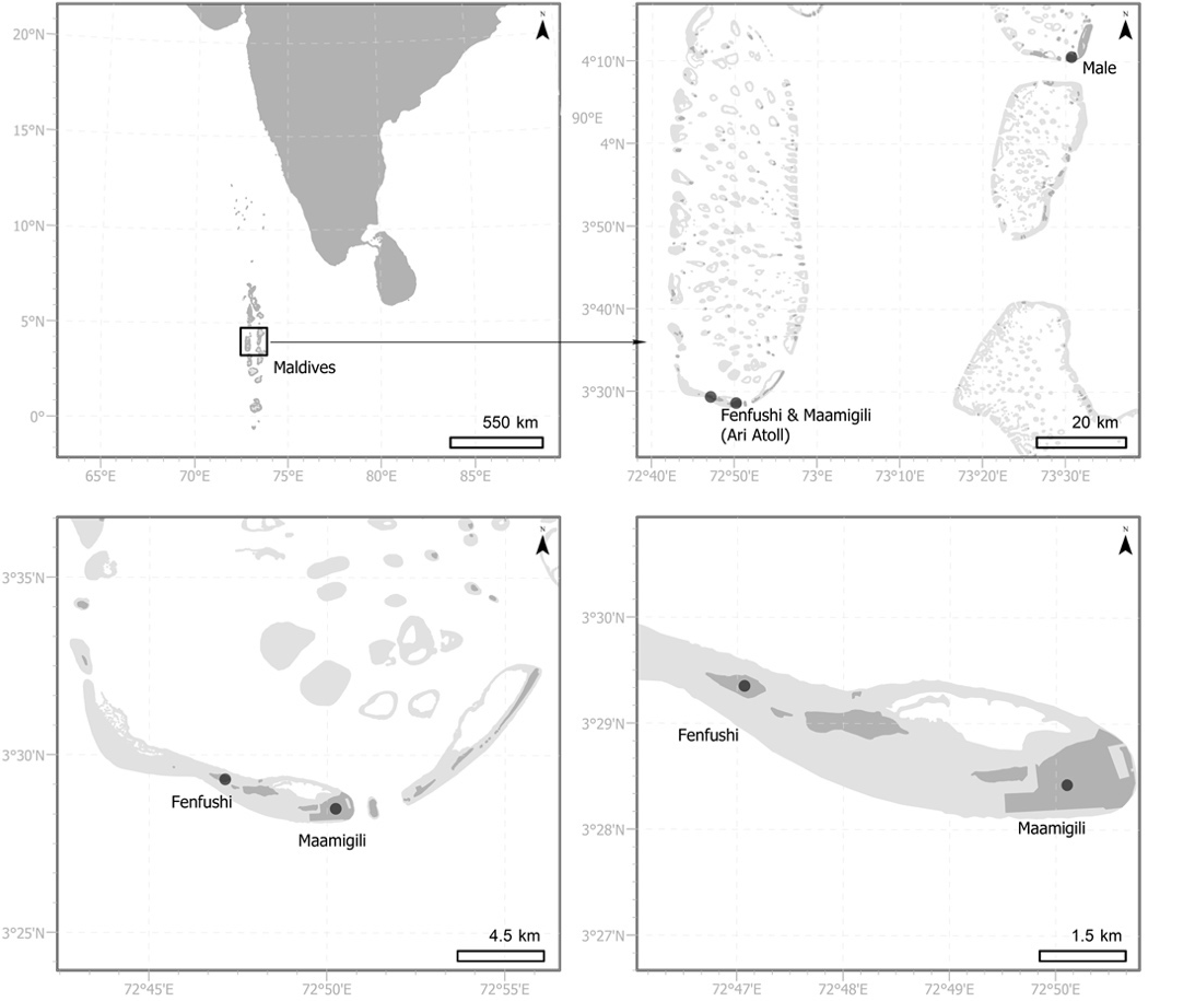
The Republic of the Maldives is located in the Indian Ocean, southwest of Sri Lanka and India. The total land area adds up to 298 km2 divided into 1,192 coral islands which are organised in 26 atolls, spread over 820 km. Malé, the capital city, is the most dynamic socio-economic hub of the country. It experiences a heavy influx of migrants from other islands, and its population accounts for about 37% of the whole population of the Maldives (National Bureau of Statistics, 2014b). The islands of the Maldives are geographically spread over a large area, and the island communities experience significant variations in their economies and lifestyles (Fulu, 2007). 188 islands are inhabited, out of which 74 have a population of over 1,000 people. Only 35 islands have an area over 1 km2 (National Bureau of Statistics, 2014a). The individual islands each have specific contexts that determine and reflect different practices and dynamics which in turn define the respective community’s degree of vulnerability and resilience.
The 2004 Indian Ocean Tsunami is considered the worst natural disaster that the Maldives has faced (Fulu, 2007), and the entire Maldivian population has been impacted by the event. Some communities were internally displaced, while others suffered property damage, lost their livelihoods, experienced injuries and traumas (Croshaw, 2017). However, the Maldives are vulnerable to other disasters as well: storm surges, water shortage, and soil salinisation are other examples of hazards that the island communities face (Asian Development Bank, 2020; Food and Agriculture Organization of the United Nations, 2005). Low seismicity is reported for the Ari Atoll, where Maamagili and Fenfushi are located, with Peak Ground Acceleration less than 0.04, for 475 Years Return Period (Asian Development Bank, 2020, p. 137). The average ground elevation in the Maldives is 1.5 m above sea level, which renders the island communities more susceptible to the effects of climate change, particularly rising sea levels and risk of flooding due to changes in the rainfall patterns.
The comparative study presented here was carried out in two islands: Maamigili and Fenfushi. Both islands are located in the Ari Atoll and border the South Ari Marine Protected Area (Rasheed et al., 2016). Maamigili has a total land area of 1.7 km2 and hosts a population of 2,359 (National Bureau of Statistics, 2019). Located 107.6 km away from Malé, it is accessible through both a ferry system and an airport and is one of the few islands in the Maldives that caters for guesthouse tourists. Following the 2004 tsunami, the entire population of Madifushi was relocated to Maamigili (Kan et al., 2007). The island of Fenfushi is located 110.8 km away from Malé. Its total area is 0.22km2 and its total population adds up to 837 residents. Fenfushi is accessible only by ferry, and tourism is limited to daily excursions to visit the Coral Stone Friday Mosque.
__mal_in_kaafu_atoll_(top_right)_.png)
These two islands were chosen for a comparative study due to their geographical proximity yet distinguishing contexts, which would highlight how the real and/or perceived risks to hazards may vary within and across the islands’ communities. As indicated above, both islands are located in the same geographical setting and hence it is assumed that they are subject to similar geo-physical and environmentally induced hazards. However, the size of the islands and of their populations provides different contexts and challenges to the respective communities. The islands’ communities have different levels of accessibility and different outlooks regarding the economic developments of the islands. Further, the community in Maamigili includes a cohort that had to be relocated from Madifushi following the 2004 tsunami who may, therefore, have a different outlook towards disaster resilience. As indicated in Figure 1, Maamigili is larger than Fenfushi, with part of the island being reclaimed. Maamigili has an airport suitable for international flights, port facilities serviced by ferry, and relatively adequate power generation capacity and electrical grid, with a more robust coastal protection structure. These factors have contributed to the investment in guesthouse tourism that accommodate short-stay visitors for a few days. In comparison, tourists from neighbouring resort islands mainly go to Fenfushi to visit the Friday Mosque as part of a day excursion, since no tourist accommodation facilities are available on the island. While various studies have focused on geohazards in urban settlements (Borg et al., 2010; De Gregorio et al., 2010; Mazzolani et al., 2010; Narasimhan et al., 2010), the geographical setting of the islands in the Maldives, including Maamigili and Fenfushi, presents a significantly different scenario.
Research methodology
The research strategy adopted was designed specifically (but not exclusively) for the Maldives within the CABARET Project Framework (Borg Axisa et al., 2019). The strategy assumes that enclaved communities develop particular dynamics with their surrounding environments, based primarily on their geo-cultures as a result of their everyday (ordinary) experience within a space rather than extraordinary events that impact their place and their livelihoods.
The data generated through this research strategy provides information on the communities’ perception of their vulnerability to disaster. This data generation process zooms from the generalised ideas of the researchers to the understanding of the individual islander who might not be in a leadership position within the community but who is still sharing the same space as the other members of the community. It is the experience of living in that space that determines the understanding, perception, and feedback of the respondents, which overall reflects the position of the community at large. This grants technical experts baseline information about the islanders’ understanding of the dynamic environmental processes and their coping strategies and resilience practices that would serve as human capital in the drawing of a hazard mitigation plan. This plan may include even the endorsement of sustainable practices as preventive measures for long-term, slow onset disasters by addressing any knowledge lacunas or malpractices within the community.
The research strategy includes both qualitative and quantitative exercises, namely interviews in the first phase and questionnaires in the second phase. The initial phase of the research included formal semi-structured interviews with policy makers and community leaders to identify their main concerns and challenges related to the safety of islanders from probable and potential disasters. This phase of the research provided insights on the broad scale, at a national level that then zoomed in to the local scale. An interview was held with the National Disaster Management Authority in Malé to understand the main challenges encountered by the Authority in setting a DRR plan for specific island communities such as Maamigili and Fenfushi. The limited human resources within the Authority, combined with the geographic dispersion and fragmentation of the territory and the remote location of the islands, set a greater challenge for the policy makers to identify and classify the hazards within specific contexts, in view of the socio-environmental dynamics within the islands that may either address or degenerate further the situation.
Another set of interviews was held with the Island Council members of both Maamigili and Fenfushi. The islands have a structured governing system where the Island Development Council plans the strategy for the development of the island. The Council expresses any requirements to the Atoll Office to get the necessary funding and support, which may in turn go to Malé for support.
During the interviews, the Island Council members provided important insights on the environmental issues, risks, concerns, and limitations the island communities face. It was immediately apparent that the main concerns of the communities were related to the lack of infrastructure that would determine the standard of living and the quality of life of the islanders, rather than directly related to geo-physical hazards. From these initial talks with the locals, the research team could perceive that the island communities of Maamigili and Fenfushi developed a geo-culture based on solidarity within the community to overcome the threats posed by specific local hazardous episodes with abrupt onsets, such as extreme weather conditions that lead to flooding or tree falls, rather than long-term environmental threats that require specialised technical support and infrastructure, such as the threat from water shortage, poor water quality, or soil salinisation.
One has to appreciate that the Council consists of members of the community who have a good grasp of the daily issues that islanders face; they are not simply administrators who are remotely located. The Island Council members of both Fenfushi and Maamigili were strategic gatekeepers in this research. They supported the research team by bridging the communication with the local community. The presence of a member of the Council whilst meeting the islanders helped the respondents to feel more comfortable to narrate their experience. Not only did these initial talks provide insights regarding community experiences and perceptions of vulnerability, but they also outlined the toll of the administrative demands of a structured system that is distant from the administrative hub in Malé.
Since the objective of the study is to focus on the perceived vulnerability of the local communities towards environmental disaster, a questionnaire (as a quantitative research strategy) was conducted in the second phase, so as to give a voice to every member of the community, in order to get a clear indication of the socio-environmental dynamics on the island and identify the main concerns of the population. The questionnaire responses of the members of the community provided a list of key issues. The incidence of issues listed by respondents validated and confirmed key concerns within the community.
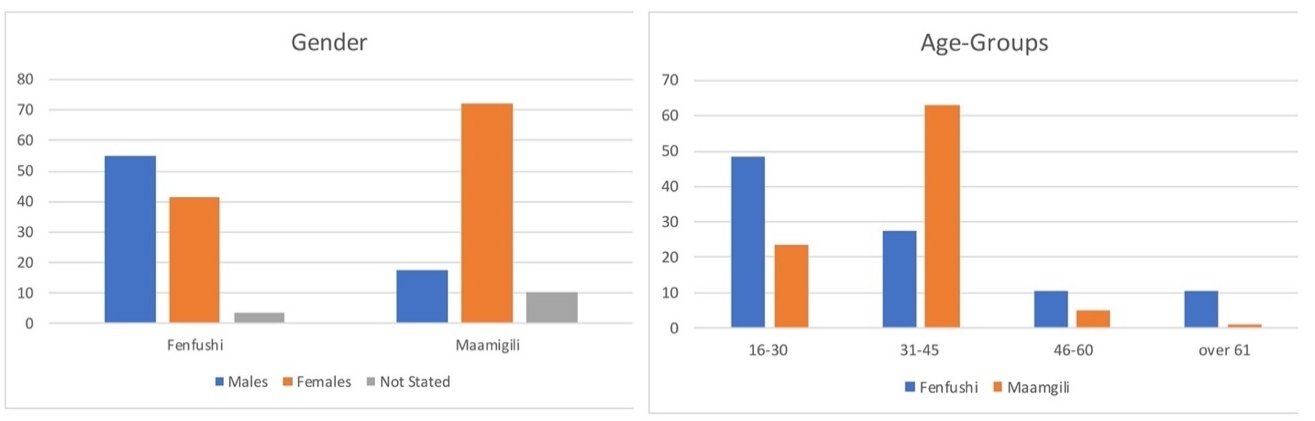
The data generation procedure was intended to include a representative sample of the community. The sampling method was not intended to take a gender-blind approach. Women were invited to participate in this study not because they are considered a vulnerable cohort of the community that require assistance, but because they are considered important pillars of the local communities — especially since, in some cases, men leave their home island for several months to work in resorts on other islands (Thamizoli, 2012). Moreover, the response to disaster is related to gender roles and the socio-political status of the pre-disaster situation (Kumar-Range, 2001). A random sampling method was used for the distribution of the questionnaire whilst the research team interacted with the inhabitants of Maamigili and Fenfushi. The target sample for the questionnaire was about 10% of each respective island’s adult population. This target was effectively reached for both communities. The sample of participants in the questionnaire is representative of the whole island community, since it includes males and females of different age groups. The questionnaire was kept as simple and short as possible so as to encourage the participation of all the members of the community; using elaborate terminology and any reference to the conceptual framework behind the study might have conditioned the response rate. The questionnaire was developed in English, and then translated and distributed in the Dhivehi language.
The questionnaire was divided into three sections, as described by Borg Axisa et al. (2019). In the first section, the respondents had to indicate whether they had always lived in the island in question or whether they had moved there from another island, and, if so, the reason behind their migration. These questions were included to determine whether the respondents included any residents who had been displaced and relocated following the 2004 Indian Ocean tsunami. It is believed that their understanding of vulnerability and their geo-culture would be different from that of other islanders who would not have experienced living in other contexts and who might not have lived through the trauma of the event that eventually led to their uprooting.
The second section of the survey was related to the general particulars of the respondents in order to trace whether the participating cohort is a representative sample of the community. The questions were related to participant gender, age, and level of education, since each of these factors influence the respondents’ understanding and perception of risk and vulnerability.
The last section of the questionnaire focused on the respondents’ consideration of potential environmental hazards. Since this study is taking into consideration not only specific geo-hazard or eventful disasters, such as the 2004 tsunami, but also ongoing environmental threats and risks that may silently and gradually encroach on the quality of life of the inhabitants, the respondents were provided with a list of environmental hazards that might affect them and asked to indicate their sense of vulnerability to such hazards. The list included water shortage and poor water quality, food shortage, storm surge, tsunami waves, soil salinity and infertility, decline in the fish stock, coral reef degradation, displacement due to disasters events, coastal erosion, flooding, marine pollution, waste management, and energy supply. The respondents could add more to the list provided. The list of environmental hazards provided, is a reflection of the researchers’ general awareness of possible hazards which the local communities might be facing, and was drawn by the research team based on literature that describes the social dynamics in the islands and the infrastructure facilities in place, considering also the islands’ size, remoteness, and accessibility, and low-lying coastal morphology affected by the climatic conditions of monsoon circulation. Rating these hazards from ‘high risk’, ‘moderate risk’, ‘low risk’, to ‘no risk’ reflects the specific threats that the participants feel vulnerable to. When taking into consideration the response of other participants from the same community, it is possible to portray the context and its complexity for each specific island. The general list of possible hazards impacting on the island’s community was therefore narrowed down to the threats perceived by the local community based on the feedback of the inhabitants of the community, and not only that of the community leaders (Borg Axisa et al., 2019). In the last question, the respondents had to indicate whether their sense of vulnerability to specific hazards was conditioning their lifestyle — whether it is influencing their future plans, including the possibility of moving somewhere that is perceived safer. This question allows the technical experts to understand the severity of the sense of vulnerability of members of the local community and to get an idea of how the demographic context of that island may change (Borg Axisa et al., 2019).
On a number of occasions, the islanders who agreed to fill in the questionnaire started a conversation that provided more details to the response required through the survey. These conversations developed into proper detailed interviews with some locals, and indicated the assistance that they feel should be provided to mitigate on certain real and perceived hazards.
McNeil and Chapman (2005) state that in order to include the community in setting DRR strategies, ‘outsiders’ must not simply set a structured survey but immerse themselves in the communities and work in partnership through interviews, workshops, and focus groups. When deciding on the research strategy for the current study, the plan was always for the research team of technical experts to visit the area of study so as to understand better the context of the study and the social dynamics within that context. The research strategy did not consider the distribution of the questionnaire via post or email, as the response rate would likely have been very restricted and not representative of the whole community. This approach would have jeopardised the underpinning principle of the research strategy, as the data generated as ‘base line’ for a DRR plan would have not been based on the mutual expertise of the technical experts and the local community. Working in partnership with the community, rather than simply communicate information to them, is a means to empower communities (Borg Axisa et al., 2019).
The participation of academics from the Maldives National University in Malé facilitated communication with the local communities on various levels. The most obvious hurdle that they helped to overcome was the language barrier, since most of the participants in the research were more comfortable to express themselves in the Divehi language (as opposed to English). As Maldivians, they had better knowledge of the local context, and easily identified the contact persons at different entities and the islands’ councils. Moreover, their presence helped in building faster trust with islands’ councils and communities.
Results and discussion
The objective of this research is to understand the sense of vulnerability of the island communities in Maamigili and Fenfushi in the Ari Atoll of the Maldives. The underpinning concept is to include the islanders’ position in the drawing of any DRR strategy so as to enhance the disaster resilience of the community. It is believed that this is possible only through the direct participating of the islanders, through a representative sample of the whole community rather than through a representation of a specific cohort of the residents. The 10% of the local population in both islands who participated in this research is representative of the island’s community. The participating cohort includes both males and females as illustrated in Figure 2. The respondents’ ages range from 16 years to over 61 years in both islands, therefore are representative of the economically active cohort. The large cohort of females between 31–45 years in Maamigili is explained by the fact that these participants were parents of children attending school who agreed to complete the questionnaire during dismissal time at the end of the school day. It is also noted that the lower number of male respondents in Maamigili is attributed to the fact that a significant number of male inhabitants work in the adjacent resort island. As noted earlier, within island communities in the Maldives, women are an asset for managing the hazard mitigation strategies as part of the DRR plan, since they are consistently on the islands, whereas men usually leave to other islands, including island resorts, due to their work commitments. Moreover, since the sense of vulnerability varies among different age groups, and considering that women are the primary care givers to both children and the elderly in the community, they may also voice the concerns of other members of the community that might be underrepresented in such a study.

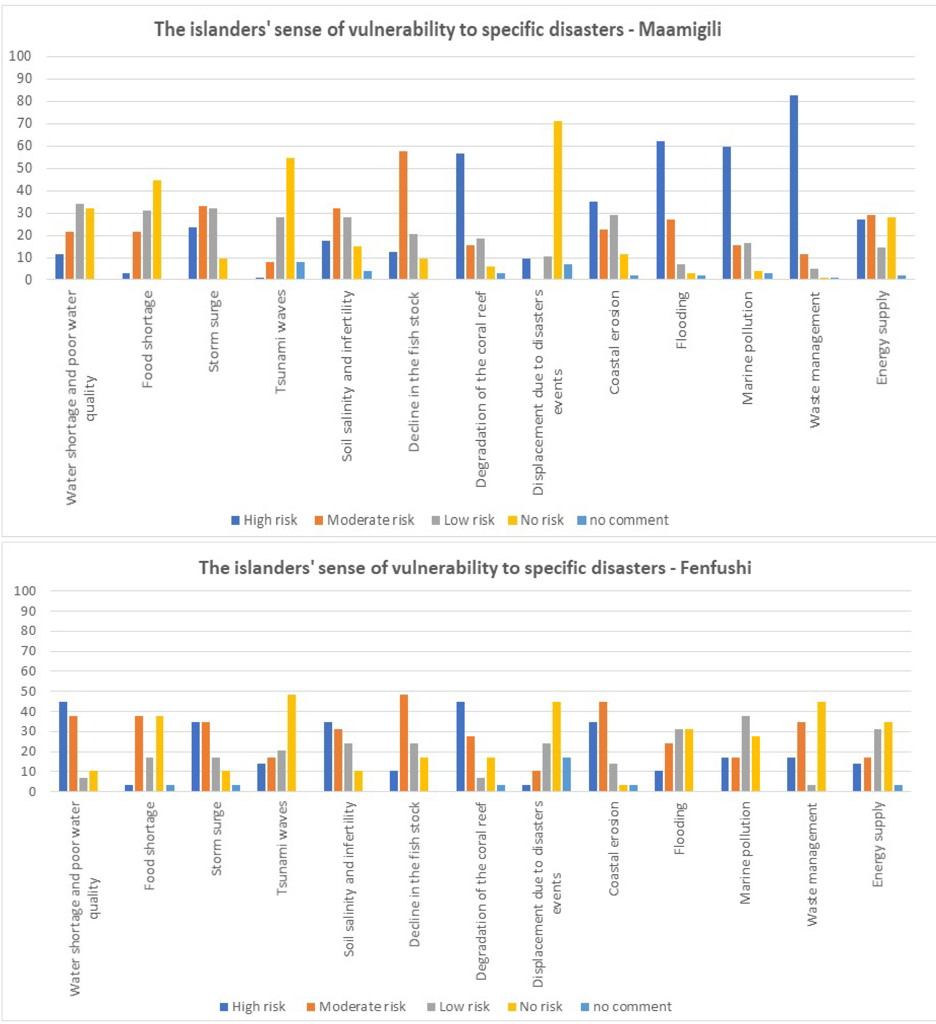
Figure 3 illustrates the islanders’ sense of vulnerability to specific disasters, indicating striking differences and similarities. The feedback provided independently in each island community regarding specific disasters concurs. This validates the specific answers and substantiates the concerns expressed individually by the participants. One of the main concerns pointed out by the Fenfushi Council was the lack of water availability, especially during the dry season. This situation is reflected in the response to the survey where 83% of the respondents consider ‘water shortage and poor water quality’ as offering moderate to high risk, with 45% opting for ‘high risk’. The sense of vulnerability to lack or poor water quality is reflected even through the feedback provided about ‘soil salinity and infertility’, where 65% feel that is a high to moderate risk. This is particularly significant since one of the sources of water for the Fenfushi community is ground water reserves that may be affected by salinisation. As one of the island Councillors pointed out, there is an increase in the incidences of kidney failure among members of the community, which is attributable to poor water quality due to salinisation and periods of water unavailability. The majority of the respondents of Maamigili do not classify ‘water shortage and poor water quality’ as moderate to high risk as was the case in Fenfushi. Yet, in Maamigili, overall 67% of respondents consider this aspect as a threat to the community, with the majority 34 % classifying water shortage and poor water quality as ‘low risk’, and 32% do not feel vulnerable to this issue. In both islands, food security is not considered as a ‘high risk’, but in Fenfushi the number of respondents that classified this issue as moderate risk is higher than that of Maamigili. One cannot ignore that soil fertility is affected by soil salinisation and this may in return contribute to the sense of vulnerability to food shortage. In line with this, the possibility of food shortage and lack of water were among the most frequent concerns expressed by the respondents in Fenfushi in the open questions at the end of the survey. For both island communities, the reduction of the fish stock — which is one of the sources of their food — is of moderate to high risk, with both scoring over 50%.
The community in Maamigili considers ‘waste management’ as posing high risk (82%); this aligns with the feeling that marine pollution poses a high risk. One of the sources of marine pollution in the region is actually waste, due to the absence of waste management strategies on various islands. In Fenfushi, on the other hand, neither ‘waste management’ or ‘marine pollution’ are considered as ‘high risk’ issues. This may be attributed to the fact that the island’s council has embarked on a project for composting and waste management and, therefore, the responses were influenced by the community’s sense of agency in this regard. However, poor sanitation and lack of sewage systems may contribute to a hazard which did not feature in the community’s responses, thus highlighting the importance of collaboration between experts and the local community in a DRR.
__data_from_ma.png)
Both island communities consider the threat from storm surges as high to moderate risk, with 68% in Fenfushi and 57% in Maamigili. However, a closer look at the breakdown of the responses indicates that the perception that storm surges are posing higher risks is higher in Fenfushi (34%) than in Maamigili (24%). Whereas the survey does not provide any further indication as to what may cause this higher sense of vulnerability to storm surges in Fenfushi, and there has not been an opportunity to delve into more detail with the local community on the matter, this may be explained by the smaller size of the island, since the extent of the ‘inland area’ for the local to avoid the surges is restricted.
The response to the risk from storm surges contrasts with the response to the risk from flooding comparatively between the two islands. Whereas the community of Maamigili feel moderately vulnerable to storm surges (24%), they feel much more vulnerable to flooding (62%). It seems that the source of water (either from the sea or from rain) makes a difference to the residents of Maamigili. This may be explained through a closer look at the geomorphology of the island, such as the extent of the sand dunes, and the infrastructure facilities related to the harbour or airport facilities that might interfere with the draining of rainwater. In contrast, the residents of Fenfushi specify that the risk from flooding is very low, with some respondents feeling that there is no risk at all.
The difference in the sense of vulnerability of the island communities in Maamigili and Fenfushi to storm surges and flooding indicates that although the two islands are close to each other and exposed to similar geo-physical and climatic conditions, the communities face different situations that reflect that generalized assumptions and, as such, plans for specific islands are not transferable, since these would not be addressing the gaps and the needs of the communities in other islands. This point is evident even through the two sets of responses from Maamigili and Fenfushi regarding the exposure to accelerated reef degradation and coastal erosion. As shown in Figure 3, the community at Maamigili feels that they are more vulnerable to accelerated reef degradation, whereas the community of Fenfushi feels more vulnerable to coastal erosion rather than reef degredation. This sense of vulnerability may be related to the presence of an extensive reef north of Maamigili which does not extend to the north side of Fenfushi. The responses of the communities reflect the specific geographical condition of the two islands, despite their relative proximity, may differ in their level of exposure to erosion processes due to their exact location. While the reef on the north side of Maamigili may mitigate the rate of erosion to the island’s coastline, this is not the case for Fenfushi. Hence this might be the reason behind the response of the people of Maamgili regarding the rate of erosion of the coast, which they consider less worrying than degradation of the reef. This contrasts with the response of the people in Fenfushi who feel more vulnerable to coastal erosion than reef degradation, since they do not have a reef on the north side, with waves pounding directly on the coast.
A striking response to the questionnaire is the sense of vulnerability of the island communities to tsunamis. In Maamigili, only 9% of the responding population feel that the island is vulnerable to tsunami, with a total of 83% of respondents who feel that this phenomenon poses low or no risk at all. The same pattern is noted in the response of the participants in Fenfushi, as illustrated in Figure 3, where only 14% of the respondents feel vulnerable to tsunami, with 68% of respondents considering tsunamis to be of low or no threat. The feeling that the islands’ communities do not feel vulnerable to tsunamis had also already been stated during the meetings with the Islands’ Council. This perception is confirmed even through the response to whether they feel vulnerable to the possibility of the need to displace as a result of a disaster. In both islands, respondents do not see the risk of having to move to a safer location due to the risks posed by disastrous events. This is particularly significant for the responses of the community in Maamigili, which includes the displaced community who relocated from Madifushi following the 2004 Indian Ocean Tsunami, where 71% feel there is no risk at all in Maamigili. Notwithstanding the experience that the Maldives has gone through, and of these community members in particular, the general perception is that tsunamis pose no or low threat to the island communities.
The 2004 Indian Ocean tsunami was the first tsunami to ever hit the Maldives and, as evident from this study among the island communities, tsunamis appear not to feature in the islanders’ geo-culture and perceived threats. The Ari Atoll lies in an area of low seismicity (Asian Development Bank, 2020, p. 137 [Map II.128]), however the tsunami hazard is reported as being very high, with the range of Probable Maximum Wave Height being 320–450 cm (Asian Development Bank, 2020, p. 138 [Map II.129]). Despite the communities’ disregard for the risk of tsunamis, the risk is still there. As such, any DRR plan for islands, such as Fenfushi and Maamigili, where the community does not feel vulnerable to such geo-physical events would have to engage the locals so as to address this perception.
Overall, both communities feel that they are not at risk of limited energy supply, provided through diesel powered generator. However, the sense of vulnerability regarding energy supply is higher in Maamigili than in Fenfushi. The Council plans to develop Maamigili as a regional economic hub for the atoll due to its airport facilities. For such an investment on the island, an adequate energy supply is crucial, and it might be the case that the current facilities might not be sufficient to support the infrastructure envisaged for Maamigili. The sense of restriction due to energy supply in Maamigili is evident even in the response presented in Figure 4, where 64% of the respondents feel that the energy supply in the island is restricting, in contrast with the 34% response in Fenfushi.
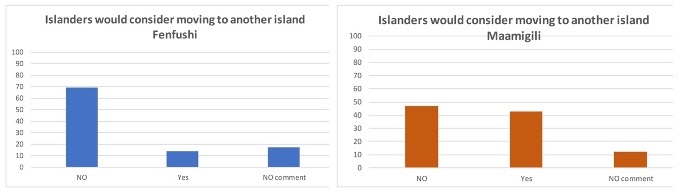
The community of Fenfushi feel that the most restricting aspect within the island is the limited job opportunities and education services, which is common also within the community of Maamigili. Following secondary schooling, young people would have to proceed with their studies on other islands. As reported to the research team, these students (who may be 16 years old) would either go by themselves to the island which provides post-secondary education, or live with family or friends on the island. In some cases, the whole family would settle on another island to remain closer to the young members of the family. Notwithstanding this context, as indicated in Figure 5, very few respondents from both Maamigili and Fenfushi seem to consider relocating to other islands — even though the largest cohort of respondents in Fenfushi were males from 16–30 years of age, who are expected to be the most likely to migrate to other locations. This feedback is corroborated even with the response regarding the sense of restriction in Fenfushi depending on mobility, where 65% feel that the means of mobility in the island is not restricting. None of the respondents identified mobility as highly restricting, although Fenfushi is reached only by sea. This contrasts with the feedback provided in Maamigili, where the majority of the respondents (61%) still feel that mobility is not restricting, however 10% consider mobility highly restricting — this on an island that is accessible not only by boat from the sea but also through airport facilities. One may study further whether the ease of access of an island such as by boat and airplane, which would allow for better mobility to and from the community, actually determines the residents’ consideration of leaving the community to settle elsewhere, as they would have better means to visit their families in their place of origin. This question is raised when considering the response regarding mobility and the intentions of the islanders to move to another island. More people in Maamigili than Fenfushi would consider moving to another island, even though the largest cohort of respondents in Maamigili were females between 31–45 years of age. This is a cohort which is expected to be more sedentary, as they are not considered as the main breadwinner and due to their commitment to take care of the household, including young children and the elderly of the family. This pattern is noted even in the feedback that the role of women in society is considered more restrictive in Maamigili than in Fenfushi, even though there were more female respondents in the larger island.


The open questions at the end of the survey allowed the respondents to point out their main concerns that might not have been considered in the previous questions. In both islands, the communities feel that both the education and the health services are not adequate enough. The communities feel vulnerable because of the lack of medical services provided. These were points listed recurrently in the survey, with respondents pointing out that they have to go to Malé for specialized medical care, and some commenting that there is no local gynaecologist or pediatrician. The health centres in Maamigili and Fenfushi provide primary health care, particularly in treatment clinics, by nurses and a doctor (general practitioner) who may not be continuously present on the island. It seems that the people of both islands feel more vulnerable to aspects related to the social dimension, such as the lack of human resources related to education and health services, rather than the geo-physical and environment sphere. Addressing these gaps for the community may be more of a short-term strategy, whereas a DRR should consider more a long-term approach in view of the call for sustainable practices as a means to mitigate hazards. This was also identified by the locals who, among their concerns listed in the open questions at the end of the survey, included the overuse of pesticides and the lack of plans to manage waste — both of which lead to health hazards in the long run.
From the responses provided by the communities in both Maamigili and Fenfushi, it appears that the very first assistance that they get is from within the community itself. Whereas the council members of the respective islands lamented that there is lack of communication and coordination with the administration in Malé even in case of an emergency situation (such as, for example, the case of falling breadfruit trees that would damage houses), the locals did not mention such situations as risks. It seems that the locals take these circumstances in their stride as a community and would not expect any assistance. One may consider whether this approach among the locals is reflecting a perception of isolation and invisibility in relation to the authorities in Malé.
It has been noted that the representatives of both the National Disaster Management Authority in Malé and the islands’ councils were frustrated with the lack of communication between the different entities engaged in setting any plan to mitigate the risks that communities might be facing. The lack of human resources, dispersion of communities, and fragmentation of the territory due to geography and servicing infrastructure are the common limitations for a coordinated effort to engage the local communities in an effective plan to reduce the vulnerability of the locals to the specific threats they face according to the space and place that they occupy. Kelman et al. (2015) suggest that the main challenges to development are the socio-environment relations which are in a continuous dynamic interaction between the network of cultures, ecologies, knowledge, policies, and practices.
This research highlights the unique locations and geographical conditions of island communities which present different challenges and risks to the local communities. In order to ensure effective DRR management planning, specific recommendations are extracted from the outcomes of this research as follows:
-
Local communities should be involved in DRR management.
-
Differences between island communities within the same atoll need to be addressed.
-
DRR management planning needs to be developed through a bottom-up approach that reflects the geo-culture of the island communities.
-
There needs to be a coordinated effort among different entities to improve management.
-
Gaps in communication and resources, including human resources, need to be addressed.
This comparative investigation between Maamigili and Fenfushi may be extended to other islands in the Ari Atoll and in other atolls where the geographical conditions may vary to different degrees. The sample of participants in the questionnaire is representative of the broader island communities since it includes males and females of different age groups. One notes, however, that as a result of the social context, in Maamigili, men work in the adjacent resort, resulting in lower male respondents to the questionnaire. Further investigation may appraise the possible different perceptions between male and female respondents in the social contexts of the island communities.
Conclusions
This research indicates clearly that although Fenfushi and Maamigili of the Ari Atoll are so close to each other geographically, the realities that their communities experience everyday are different — and that members of these communities feel vulnerable to their surroundings in different ways since their geography and infrastructure are different. The wider global community not familiar with the Maldives does not distinguish between the islands: their geographical imagination is limited to stretches of white sand washed by the clear sea dotted with palm trees. This is a simplified picture that does not distinguish how remote communities of specific islands as Maamigili and Fenfushi negotiate their livelihood within distinctive contexts that cannot be addressed through generalisations ignoring their specificity.
The results of the present study indicate that notwithstanding the close proximity of the two islands, their communities perceive that they are at risk from different hazards. The people in Maamigili are primarily concerned about waste management, flooding, and risks from marine pollution. The main concerns of the Fenfushi community are less obvious, but water shortage, water quality, and the degradation of the reef are prevalent.
This research highlights that even if two islands are so close and similar to each other, they still require separate DRR strategies so as to address the real and perceived short- and long-term vulnerabilities of the locals as a means to build more resilient communities.
Acknowledgements
The research work was conducted within the framework of the CABARET Research Project (Capacity Building in Asia for Resilience EducaTion), which provided support in the field research activity in Malé, Maamigili, and Fenfushi during August 2019. The authors would like to extend their appreciation to the National Disaster Management Authority, Malé, the Island Development Councils of Maamigili and Fenfushi, and the Head of School of H. Dh. Atholhu Madhrasa (Maamigili) for supporting the research team during their field research among the islands’ communities. The authors acknowledge the support of the local island communities for their hospitality and for supporting the field research activity.