

1. Introduction
In recent years, Japan has witnessed a growing interest in re-evaluating traditional water sources not merely as cultural relics but as important assets for disaster resilience, particularly in remote and insular regions where centralized infrastructure may fail during emergencies (Cabinet Office, Government of Japan, 2023; Endo et al., 2023; Rezig & Shevtsova, 2022). Springs and wells are increasingly reconsidered as indispensable components of emergency preparedness, providing drinking water where quality permits and supporting domestic uses such as sanitation and fire control where it does not. These concerns have intensified following the 1995 Hanshin-Awaji Earthquake and the 2011 Great East Japan Earthquake, which exposed the vulnerability of centralized supply systems (Cabinet Office, Government of Japan, 2012, 2023). National guidelines in Japan recommend storing three liters of water per person per day for at least three days (Cabinet Secretariat, 2025), yet prolonged disruptions to the centralized water supply can create additional challenges in small-island settings. In remote island contexts, logistical delays in delivering supplies can lead to deteriorating sanitary conditions and heightened psychosocial stress (Sphere Association, 2018; World Bank & GFDRR, 2012). In response, recent policies emphasize the preservation and use of local groundwater as a complementary emergency source, including during non-crisis periods, thereby integrating everyday use with disaster preparedness (Cabinet Secretariat, 2025).
Within this context, Okinawa Prefecture offers a compelling case. Although Okinawa is among Japan’s smaller prefectures in land area, more than 1,200 spring sites have been recorded in national spring-source surveys based on reports from local governments (Ministry of the Environment, Japan, 2024b). These records do not represent a complete inventory of all springs physically present in the region. Rather, they reflect springs that have been identified, reported, and recognized through local administrative surveys and community-based knowledge. Okinawa comprises 48 inhabited islands out of a total of 691 islands (Geospatial Information Authority of Japan, 2022; Okinawa Prefectural Government, 2025). This combination of small land area, many inhabited islands, and locally recognized spring sites helps explain why springs have been deeply embedded in daily life and cultural practice. At the same time, the region’s porous Ryukyu limestone geology leads to rapid rainfall infiltration and runoff, making water retention difficult (Shimabukuro et al., 2022). In many parts of Okinawa, freshwater has therefore long been a scarce and carefully managed resource.
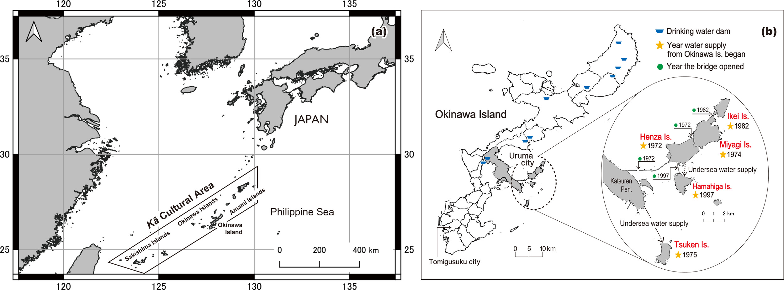
Traditionally, kā springs (hereafter kā) served as essential water sources across Okinawa and the broader cultural region encompassing the Sakishima, Okinawa, and Amami island groups. This distribution reflects a historically interconnected cultural sphere shaped under the Ryukyu Kingdom (1429–1879). The term kā is used here as a practical and consistent label for spring-based water-use sites embedded in local cultural and ecological contexts. Across these islands, such sites are known by diverse names, including gā, hā, nā, kē, gō, hījā, and waku, each associated with specific practices and forms of local knowledge. The use of the term kā does not imply homogenization but serves as a comparative reference point across these traditions. In many communities, kā function not only as sources of water but also as shared spaces where daily practices such as cleaning, water collection, and ritual acts of gratitude are performed, linking material use with social and spiritual life. They have long been integral to local communities and remain culturally significant today (see Fig. 1).
Beyond their physical functions, kā have long carried cultural and spiritual meanings. In many island communities, they are regarded as sacred spaces associated with water deities and ancestral spirits, where access and use are shaped by shared norms rather than open availability. Related sacred landscapes, such as utaki, are often associated with more formal ritual practices under priestly authority (Røkkum, 1998), while recent scholarship has emphasized their role as socially regulated sacred spaces in which access and meaning are negotiated among different actors (Rots, 2019). Within this broader ritual landscape, kā function as sites of cultural memory and everyday care, where people gather to clean, collect water, and perform acts of gratitude.
Kā have historically mediated relations among people, water, and spiritual beings through everyday practices of care, offering, and collective remembrance. These practices do not imply unrestricted access; rather, they are organized through shared norms that regulate who may enter, when, and how. What may appear as “inaccessibility” is thus a culturally defined mode of engagement maintained through ritual and social expectation rather than physical exclusion. In this sense, kā are not open-access public goods but locally governed commons sustained by tacit norms and collective memory.
The spread of piped water systems since the late twentieth century has reduced practical reliance on kā and contributed to their marginalization in everyday life. As locally embedded practices have weakened, forms of mutual support associated with these water places have also become less visible. Some kā have been formally recognized within official cultural heritage frameworks, but such designation often reframes them as objects of preservation rather than as actively maintained commons. Many others have become disconnected from daily use. This growing dependence on centralized infrastructure exposes vulnerabilities in island contexts and highlights the need to reconnect cultural memory with everyday practice through local management.
Amid these concerns, this study examines how kā can be revalued as community-based resources that may support disaster preparedness. It focuses on the island region of Uruma City, where kā once provided the primary water supply and where disruptions to modern pipelines pose significant risks. Revaluing kā therefore requires technical maintenance as well as renewed engagement with the cultural meanings, historical practices, and community relationships that give them significance. Rather than being inert relics, kā continue to serve as focal points of ritual and collaborative practice, linking everyday life with broader systems of belief (Rots, 2019).
In conceptualizing kā in this way, this study draws primarily on the framework of Social-Ecological Systems (SES) to analyze the interdependence of ecological processes and social practices (Berkes & Folke, 1998; Ostrom, 2009). It also attends to ritual practice, memory, identity, and spiritual heritage. This approach makes it possible to examine kā as places where ecological functions and socio-cultural relations are closely intertwined. Methodologically, the study adopts an integrated approach that combines scientific data, such as water-quality indicators, with oral histories and ethnographic narratives (Lang et al., 2012; Raymond et al., 2010).
By reconnecting kā with contemporary disaster resilience and cultural continuity, this study contributes to interdisciplinary discussions in island studies and resource anthropology on adaptive governance. It links local challenges in Okinawa to broader debates on islandness and small-island governance (Baldacchino, 2007b), arguing that resilience depends on engineered infrastructure as well as on relationships among people, place, and water.
_okinawa_islands__sakishima_islands__and_amami_islands__indicating_the_approximate_exte.png)
To develop this argument, kā are approached as relational infrastructures within island social-ecological dynamics. The analysis examines how kā are being revalued in contemporary island contexts by tracing the interconnections between ecological function, cultural memory, and community practices of care.
2. Theoretical Framework and Conceptual Approach
This study situates kā within an analytical framework centered on Social-Ecological Systems (SES), while foregrounding the role of islandness and cultural practice in shaping water governance. SES approaches were developed to move beyond the separation of social and ecological analysis by treating human communities and biophysical environments as interdependent systems (Berkes & Folke, 1998). Building on this perspective, Ostrom (2009) elaborated the Social-Ecological Systems Framework (SESF) as a diagnostic approach for examining relations among resource systems, resource units, governance systems, actors, interactions, and outcomes. Comparative work on SES frameworks shows that the SESF is particularly useful for integrative analysis because it addresses reciprocal dynamics between social and ecological systems rather than assuming influence in only one direction (Binder et al., 2013). Reviews of SESF applications further indicate that the framework has been widely used in studies of commons, resource governance, resilience, and sustainability, while requiring careful adaptation to specific empirical contexts (Partelow, 2018).
For the purposes of this article, SES is used neither as a rigid classificatory model nor as an all-encompassing explanation. Rather, it provides an analytical lens for examining how water, ecological conditions, community actors, customary practices, governance arrangements, and outcomes are connected around kā. Such a lens is necessary because kā cannot be understood solely as hydrological features, heritage objects, or potential emergency water sources. Their condition and significance depend on spring flow and water quality, but also on cleaning and maintenance work, ritual use, local memory, community organizations, and wider infrastructures of water supply and disaster preparedness. At the same time, aspects such as ritual access, ancestral remembrance, and place-based belonging require attention to islandness and cultural practice. Together, these perspectives make it possible to analyze kā as culturally embedded social-ecological water places where ecological functions, symbolic meanings, and community practices come together to sustain and transform local water governance.
In island contexts, these concerns become especially salient. Islandness is understood here not as isolation, but as a relational condition shaped by land, sea, subterranean environments, infrastructure, and human practices (Gaini, 2024; Stratford et al., 2011). Limited land area, dependence on external infrastructure, and exposure to environmental risks intensify the coupling between ecological conditions and social organization (Baldacchino, 2007a). Across the island groups of Okinawa, Sakishima, and Amami, kā offer a concrete case of such coupling. Their historical use required coordination among households, local leaders, and ritual specialists to allocate water, keep spring spaces clean, and conduct ritual practices. These activities linked ecological conditions with social coordination and collective responsibility. The introduction of piped water systems weakened these linkages, illustrating how infrastructural modernization can decouple relationships among people, water, and place.
The analysis must also account for forms of value that are not captured by hydrological or institutional categories alone. Kā are associated with spiritual meaning, cultural heritage, place-based belonging, and everyday forms of remembrance. These values are expressed through ritual acts, oral traditions, and routine engagement with spring sites. In Okinawan religious belief and practice, the sacredness of kā can be understood in relation to shiji, a spiritual force or power associated with persons, places, natural features, and material things. Lebra (1966, pp. 26–27) explains that shiji could be present in the water of a well and was regarded as beneficial to its users. This suggests that kā water may be understood not only as a material resource but also as a medium of spiritual vitality, helping explain its use in practices of protection, blessing, remembrance, and gratitude.
Ethnographic and historical accounts indicate that many kā also serve as sites of worship (uganju) and are often associated with utaki, which are key ritual spaces in Okinawan religion. Their relationship is not uniform: some kā are themselves understood as sacred sites, while others are located within, adjacent to, or ritually connected with utaki. Practices such as ubi nadhi (applying kā water to the forehead for spiritual protection and blessing), waka miji (fresh water drawn from a kā at dawn, usually on the Lunar New Year, for family health and longevity), and kā ugami (prayers offered at lineage-related springs) illustrate how kā mediate relationships among people, ancestors, and water deities. These practices are often performed at the household or lineage level, in contrast to more formal village rituals conducted at utaki, which were historically administered by female ritual specialists, including noro and other locally specific practitioners (Lebra, 1966; Røkkum, 1998; Wacker, 2003).
Access to kā is culturally regulated through layered ritual practices. Kā are therefore tied to kinship, lineage, and territorial belonging, rather than defined solely by their physical characteristics. These practices indicate that kā are not static features but historically shaped environments maintained through ongoing engagement. Variations in participation across islands reflect broader social changes, including demographic shifts and transformations in community organization. In this way, kā remain sites through which cultural memory and social ties are carried forward over time.
Building on these points, this study conceptualizes kā as relational infrastructures. The term highlights water places whose continued significance depends on built structures and formal institutions, but also on cleaning, monitoring, ritual care, local memory, and everyday forms of cooperation. Kā provide freshwater and support localized ecosystems. Community maintenance and local governance give them commons-like qualities, while ritual and ancestral associations allow them to retain cultural significance. This framing shifts the analysis away from a simple narrative of decline. It instead highlights how residents, newcomers, off-island participants, and institutions may share, negotiate, and reorganize practices of care, responsibility, and participation in uneven and changing ways.
3. Study Area and Research Design
Within this wider island region, this study focuses on five inhabited islands in Uruma City: Ikei, Miyagi, Henza, Hamahiga, and Tsuken (Fig. 1). Although geographically close to Okinawa Island, these islands differ in accessibility and water-resource conditions. Today, all five islands rely on piped water for domestic uses, although multiple kā remain on each island and some continue to be used for limited purposes such as agriculture. Henza is connected to Okinawa Island via the Mid-Sea Road, locally known as Kaichū Road, a causeway-and-bridge route constructed across a shallow tidal area. From Henza, bridges extend to Miyagi and Hamahiga, while Ikei is further connected to Miyagi by a bridge. Tsuken, the only island without a bridge, relies solely on ferry transport, creating relative isolation and limited redundancy during emergencies (Uruma City, 2023).
These islands were selected because they share historical reliance on kā while exhibiting contrasting hydrological conditions, demographic changes, and maintenance practices. Prior to the introduction of piped water systems, residents of Ikei and Tsuken reportedly collected drinking water by boat from neighboring islands during periods of water shortage. Both islands are relatively flat and had limited usable freshwater sources, whereas nearby Miyagi and Hamahiga, the islands from which they obtained water, are more hilly and have a greater abundance of springs. These practices are documented in local historiography and were also recounted by residents in interviews conducted in 2023 (Miyagijima Kyōdoshi Kenkyūkai, 2020). Fieldwork was conducted between October 2022 and March 2023 and combined ethnographic observation with participatory scientific activities. The islands also differ in the number of locally recorded kā and in the ways spring upkeep is incorporated into community activities. For instance, Miyagi integrates spring upkeep into community cleanups, whereas Hamahiga faces labor shortages that make maintenance difficult. Regionally, these islands rely on a piped water network supplied by dam-fed reservoirs in northern Okinawa Island, revealing spatial vulnerabilities during disasters. Tsuken is particularly exposed because it lacks logistical redundancy. This setting makes the island region of Uruma City especially suitable for examining how kā may complement centralized water systems as localized and culturally embedded resources.
To examine kā as physical water sources, culturally meaningful places, and community-managed resources, the study adopted a mixed-methods design combining ethnographic fieldwork, dialogue-based workshops, questionnaire surveys, and participatory water-quality testing. Participant observation was conducted across the five islands through participation in rituals tied to the lunar calendar, direct observation of kā sites, and everyday interactions with residents. These observations documented how people approached, discussed, and used kā in contemporary settings, as well as how maintenance practices were organized, sustained, or neglected within each community.
Workshops and questionnaire surveys were held with residents, community leaders, older adults’ associations, and children’s groups. Each session began with simple guiding questions and developed into resident-led conversations about memories of kā, reasons for disuse, and possible responses during disasters. Questionnaire surveys were administered alongside the workshops to document perceptions of water quality, familiarity with disaster stockpiles, and willingness to maintain kā. Following each water-quality test, group discussions were held to reflect on the “value of kā” and the “necessity of preservation.” The central question guiding these exchanges was: “How can kā, no longer essential for daily life, be reimagined as vital resources in times of crisis?” While participation varied, approximately 45 percent of participants were return migrants, newcomers, or external volunteers with personal or practical ties to the communities. This composition reflected an emerging form of community participation in which non-experts contributed to monitoring and stewardship beyond the circle of long-time resident islanders.
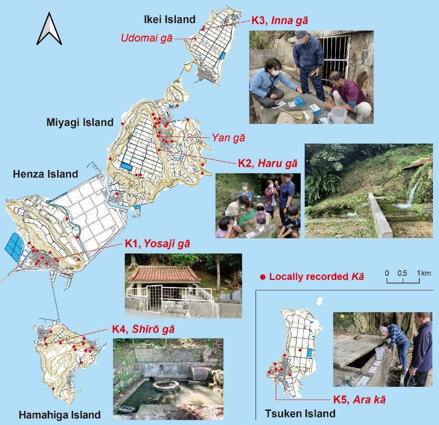
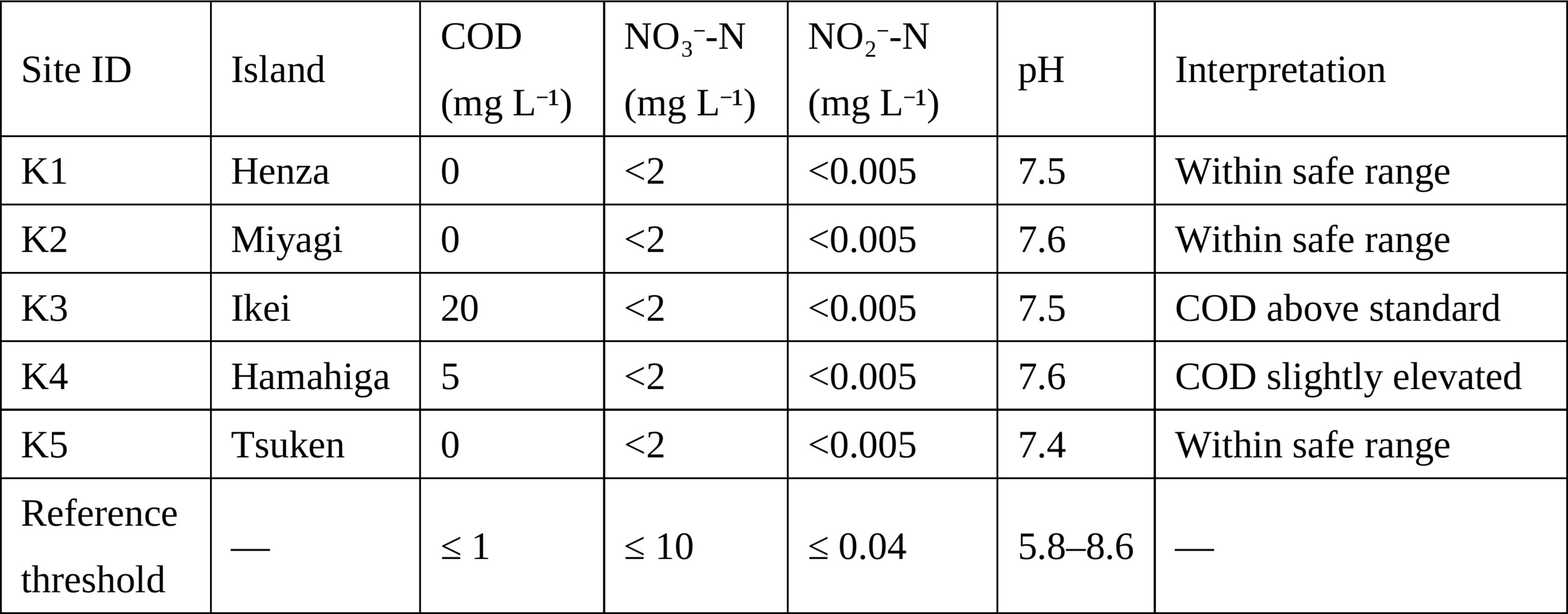
Simplified water-quality assessments were conducted jointly with residents at five key kā sites (K1–K5). Indicators included chemical oxygen demand (COD), nitrate-nitrogen (NO₃--N), nitrite-nitrogen (NO₂--N), and pH, using PACKTEST kits manufactured by Kyoritsu Chemical-Check Lab., Corp. Additional contextual measurements included air temperature, water temperature, and visually assessed turbidity. Total hardness at Yan gā on Miyagi Island was also analyzed by a specialized laboratory to contextualize the hydrogeological characteristics of Ryukyu limestone spring water (see Figs. 2 and 3). These indicators were selected for their scientific relevance and accessibility in participatory settings. COD provided a proxy for sanitary conditions, while nitrate and nitrite levels suggested potential domestic or agricultural contamination. Immediate sharing of results encouraged dialogue and reflection among participants. Although PACKTEST values are preliminary, their simplicity enabled residents to participate actively in observing and discussing water quality.
Sampling was community-based and purposive, built on prior fieldwork and collaboration with local associations. Recruitment occurred through existing relationships with community leaders and residents. Participants were informed of the study’s objectives and consented voluntarily, either orally or through continued engagement. Because no personal or sensitive data were collected, oral consent and continued voluntary participation were considered appropriate for this study design. The study followed anthropological ethics emphasizing respect, reciprocity, and cultural sensitivity. This approach enhances contextual validity even as it limits statistical generalization.
Qualitative and quantitative materials were analyzed in combination to evaluate the disaster-resilience potential of kā. Interview transcripts and field notes were coded thematically for narratives concerning memory, ritual, maintenance, and perceptions of emergency use. The coding focused on how kā were remembered and described, how collective events such as offerings and cleanups were understood, how residents expressed expectations or hesitation about revaluing kā as emergency sources, and how experiential knowledge appeared in sayings such as “Neglected kā run dry.” Quantitative data consisted of PACKTEST results and survey responses on perceptions of water cleanliness, frequency of use, and willingness to maintain kā. Cross-tabulations by island and demographic group were generated to visualize differences in awareness and engagement. Rather than aiming to establish statistical correlations, the analysis examined patterns of co-occurrence between physical conditions and social practices.
By bringing these materials together, the analysis examined how material upkeep, ritual continuity, community participation, ecological indicators, and local memories intersect across islands. This analytical integration provides the basis for examining, in the following section, how kā are being revalued within community-based approaches to disaster preparedness.
4. Present Conditions and Community Perceptions of kā
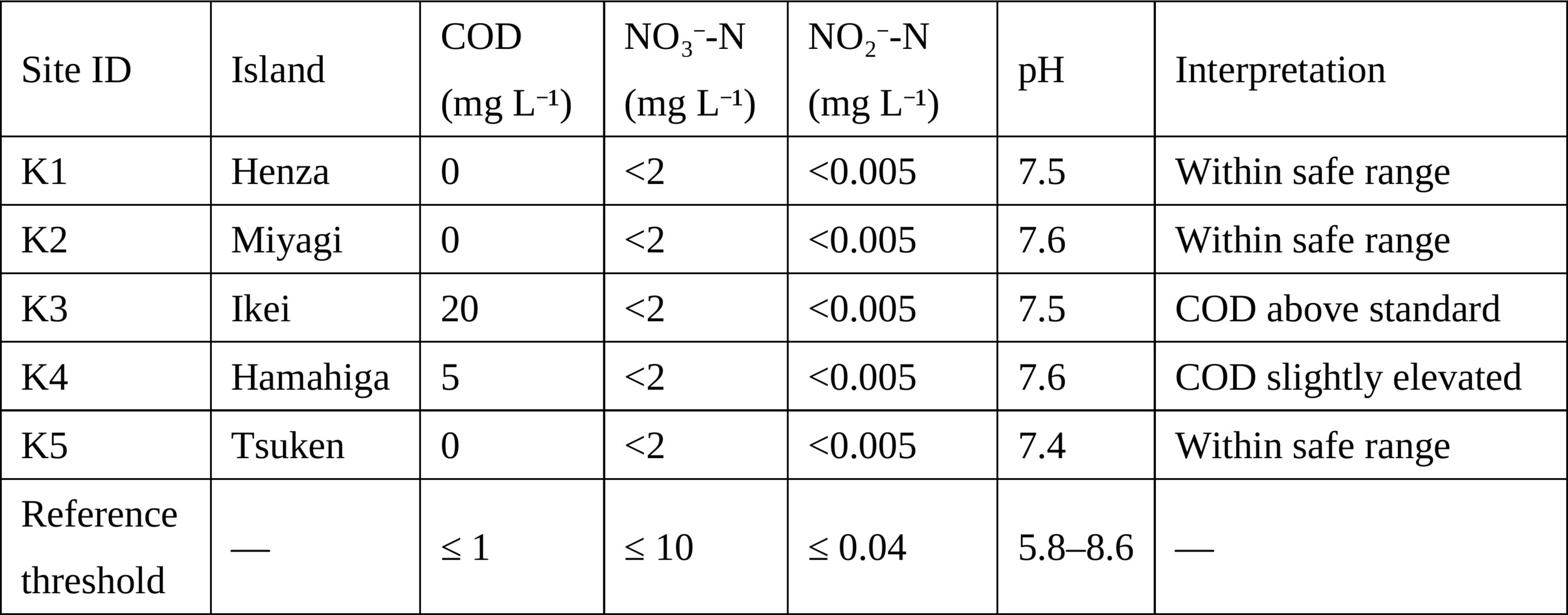
This section presents findings from fieldwork conducted across five islands in Uruma City. It examines the physical state of kā, their cultural significance, and residents’ perceptions of their possible role in disaster preparedness. Figure 2 shows the distribution of locally recorded kā and the five sites selected for participatory water-quality testing, while Table 1 presents the water-quality results.
_and_the_five_surveyed_sites_(k1-.jpg)
Physical Conditions of kā
Kā include spring water itself as well as the surrounding spaces historically maintained by local communities. These sites often contain stone walls, channels, drainage features, storage basins, and access paths, all of which require regular upkeep. Historically, the spatial arrangement of many kā reflected careful use of limited freshwater. The cleanest water near the spring outlet was reserved for drinking and ritual purposes, while water was reused downstream in stages for washing vegetables and dishes, washing clothes or bodies, and finally for animals, agricultural tools, or fields. Rather than treating all water as equivalent, this arrangement matched water quality to different uses before the flow continued toward fields or drainage channels.
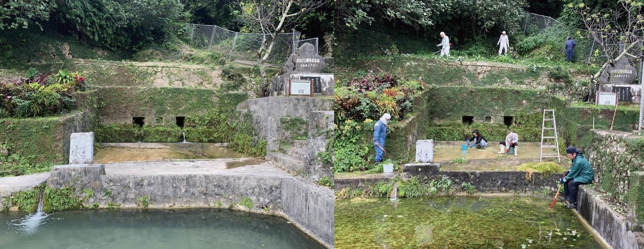
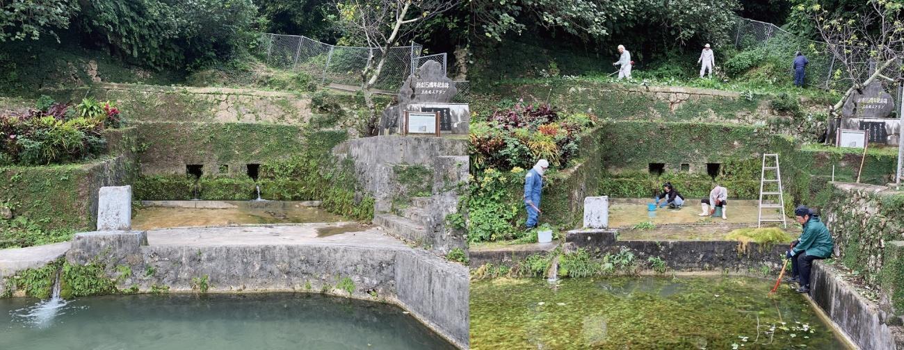
Because many kā combine natural springs with constructed water-use features, sediment and calcium carbonate deposits can accumulate in channels and outlets. Where regular work has ceased, vegetation, sediment, and stagnant water may reduce visible flow and accessibility (see Fig. 3). Some kā are also covered by roofs or concrete lids originally intended to protect the water from leaves, debris, and contamination. Once they are no longer used regularly, however, these protective structures can make the water less visible and may contribute to stagnation.
Water-quality screening did not indicate serious contamination across the surveyed sites (Table 1). Nitrate-nitrogen (NO₃--N) and nitrite-nitrogen (NO₂--N) concentrations remained within Japanese drinking-water standards (Ministry of the Environment, Japan, 2024a), and all sites fell within the acceptable pH range of 5.8–8.6. Only Ikei (K3) and Hamahiga (K4) showed elevated COD values, suggesting possible organic contamination. These deviations were limited and did not correspond to deterioration in other indicators. Because PACKTEST kits differ from the official acidic-heating COD method, the measurements should be interpreted as screening values rather than definitive assessments.
During water-quality testing, air temperatures were approximately 20°C and water temperatures ranged from 21°C to 22°C. At Yan gā on Miyagi Island, total hardness was estimated at approximately 424 mg L-1 as CaCO₃ from calcium and magnesium concentrations, placing it within the “very hard” category for drinking-water hardness (World Health Organization, 2022). Although hardness was measured at only one site, the result is consistent with the hydrogeological characteristics of Ryukyu limestone areas and with residents’ perceptions that Miyagi’s spring water is mineral-rich and distinct from the municipal supply, which is treated and adjusted to a lower hardness for drinking.
Field observations were consistent with biodiversity reports concerning the Ryukyu Islands (WWF Japan, 2010), suggesting that many kā provide small habitat patches within subtropical vegetation. Across the surveyed islands, I recorded aquatic plants, mosses, dragonflies, frogs, freshwater shrimps, small fish, and terrestrial insects around kā, particularly along stone walls, channels, and shaded margins where moisture was stable. Hydrogeochemical research on Ryukyu limestone springs indicates that such springs may be sustained by groundwater flow paths with multi-year residence times, providing relatively persistent hydrological conditions (Toki et al., 2022). Together with shade and locally humid microenvironments, these conditions may help explain why organisms associated with moist habitats were observed around kā. One kā on Miyagi Island also provides habitat for a rare freshwater red alga associated with clear spring waters in limestone areas of the Ryukyu Islands. This habitat is designated as a natural monument, showing that distinct ecological characteristics can develop in and around kā spring sites (Higa, 2018). Although kā have historically been shaped for human use, their surrounding environments also support organisms that depend on stable water, shade, and microclimatic conditions.
Maintenance conditions varied across islands and local communities. In Okinawa, each island is composed of one or more administrative community units known as aza, each of which usually has its own community association. Regular community cleanups are commonly organized by these associations, typically four times a year, and may include mowing grass, cleaning public spaces, and maintaining the surroundings of kā.
When kā served as everyday water sources, upkeep involved more labor-intensive work, including removing sediment, scraping limestone deposits from channels, repairing stonework, and cleaning storage pools to keep water flowing. In Okinawan communities, such collective cleaning is often referred to as kā-sarē, a term combining kā with sarē, meaning to dredge or clean. These activities were not merely sanitary or technical tasks; they could also form part of embodied ritual care, linking physical work with gratitude toward the beings and ancestors associated with the spring. Today, such intensive work has declined because kā are no longer needed as primary water sources. In many cases, cleaning now consists mainly of sweeping paths, cutting grass, and keeping access routes open. Kā may therefore remain ritually respected as sacred or ancestral places while receiving only limited physical maintenance.
The number and condition of locally recorded kā vary across the five islands and cannot be explained by a single factor. Miyagi has 23 such kā, Henza has 14, Hamahiga has 13, Tsuken has 7, and Ikei has 3. Their present condition depends on how each site is incorporated into community-based cleaning, local memory, ritual meaning, and available labor. Field observations indicate that maintenance is shaped by hydrological conditions, cultural significance, community leadership, and the practical capacity of local associations.
Cultural Practices and Changing Community Structures
Across the islands, engagement with kā produced uneven but meaningful outcomes. On Miyagi, Ikei, and Henza, the project created opportunities to revisit kā as shared spaces, while Hamahiga later showed a different pattern of renewed involvement. In Ikei, the contrast between the historically sacred Inna gā and the nearby Udomai gā (see Fig. 2) illustrates how cultural significance and practical value can diverge. Inna gā, located at the base of a cliff, historically provided the island’s only potable water, while Udomai gā, although easier to access, was used mainly for agriculture and household tasks because of its lower water quality. Today, Inna gā is formally recognized as a cultural heritage site and continues to receive periodic care, whereas Udomai gā, lacking such a designation, has largely faded from everyday awareness. From a disaster-preparedness perspective, however, Udomai gā retains potential as an emergency water source, underscoring the need to evaluate kā through both cultural and practical lenses.
Participation in the Miyagi workshops was notably diverse: approximately 45 percent of participants were return migrants, newcomers, or external volunteers who maintained personal or practical ties to the communities. Community associations, children’s groups, and individual volunteers contributed in different ways, indicating that stewardship of kā now extends beyond long-time residents and is supported by broader social networks. On Miyagi Island, the surveyed site, Haru gā, was selected by staff members of the local after-school children’s club because it was both familiar to the children and had abundant flow.
During participatory water-quality testing, immediate sharing of results prompted participants to reconsider the condition of kā. Some remarked, “It is cleaner than I expected” and “We should check this ourselves,” suggesting that water testing created opportunities for renewed attention and local stewardship. In Miyagi, participants expanded their usual vegetation clearing to include cleaning stone conduits and dredging accumulated sediment. After these activities, brief words of gratitude were offered to the kā and to the water deities and ancestors associated with the site, subtly echoing earlier forms of customary practice.
By contrast, participation on Hamahiga and Tsuken was initially more limited, shaped by demographic aging and hesitancy to intervene in sacred domains. Residents often commented that “not everyone can approach the kā,” indicating culturally regulated boundaries rooted in long-standing ritual norms. On Hamahiga, however, a newcomer who had participated in the project later helped organize sediment dredging at the surveyed kā after university students visiting the island for a soccer training camp asked how they might contribute to the host community. Having experienced the disruption of infrastructure and water access during the Great East Japan Earthquake, this participant recognized the potential importance of local water sources in emergencies. For local residents, the students’ offer was also timely, because aging had made it increasingly difficult to carry out kā-sarē with local labor alone, even though the spring was still used for agricultural water. Because kā are culturally regulated and sacred places, the activity was organized only after consultation with the community association leader and with local residents’ understanding. On the day of the activity, the association leader was present and guided the students. For the students, the work also served as a way to give back to the host community and to learn about local practices. This episode showed how people with personal or practical ties to the island can support the maintenance of kā while respecting local norms of access and care.
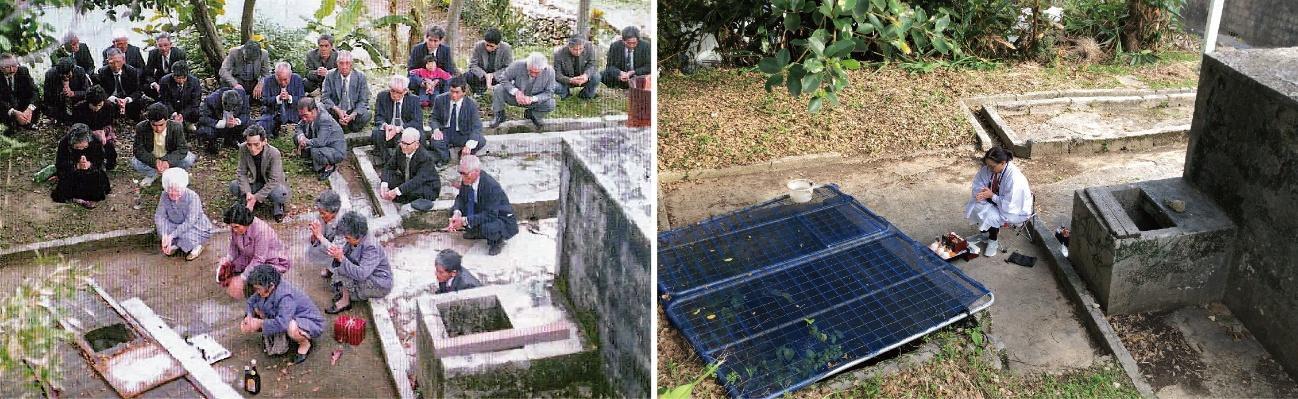
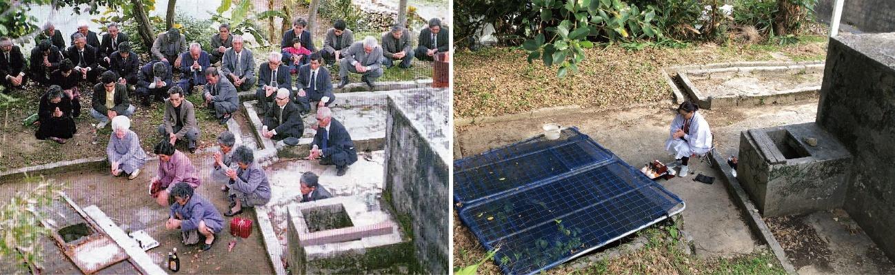
These ethnographic contrasts illuminate broader changes in community engagement. Ritual practices linked to kā continue, but participation has narrowed. Lunar New Year prayers, once communal, are now performed by a small number of representatives responsible for maintaining the ritual practice (see Fig. 4). Younger residents expressed ambivalence: “I know where the kā is, but I’ve never used it,” or “My parents drank from it, but now it might be contaminated.” Such remarks indicate that local knowledge is often transmitted through stories from older generations and through familiarity with the locations of kā, even when younger residents lack direct experience of using them. They also reveal a contemporary assumption that piped water is safer than untreated spring water.
Demographic shifts further shape participation. Population decline, aging, and outmigration have weakened traditional maintenance groups and reduced opportunities for community succession. Nevertheless, island responses to these pressures diverge. On the bridge-connected islands of Ikei, Miyagi, Henza, and Hamahiga, residents have begun collaborating with newcomers, return migrants, and external volunteers, recognizing that local labor alone may no longer be sufficient to sustain the springs. Tsuken, by contrast, faces a greater constraint because it is accessible only by ferry, making it difficult for external participants to join maintenance activities for kā that are no longer in everyday use.
During a water-testing session in Henza, members of the women’s association joked, “Our kā is sacred, so bad results are impossible, and we clean it regularly.” Their humor reflected a sense of pride grounded in hands-on care. They also described planting trees and flowers and installing safety platforms so residents could continue to feel attached to the site. These gestures show that care involves more than physical upkeep; it also sustains the relationships that give kā meaning.
Miyagi further illustrates how kā can become sites of intergenerational learning and broader participation. On Miyagi, where many kā remain, residents organize regular cleanups involving long-time residents, return migrants, and external volunteers. Children sometimes accompany family members or participate through learning activities, observing insects and small aquatic life around the springs while elders recount stories about ancestors who relied on the water. As one elder explained, “We no longer live from kā water, but it still connects us with those before and after us.” In this way, kā remain relational spaces that bridge generations and create points of contact between newcomers and local community life.
Across these cases, cultural practices surrounding kā are neither simply preserved nor entirely lost. Rather, they are being reorganized through changing forms of participation, care, and collaboration. Community-based engagement with kā therefore provides a practical response to the study’s central question: how historically embedded water places can be revalued within changing island social structures.
Residents’ Disaster Preparedness and Recognition of kā
Interviews and questionnaire responses revealed a gap between limited awareness of municipal emergency water storage and locally grounded recognition of kā as possible emergency water sources. In Uruma City, municipal disaster stockpiles, including drinking water, are placed on the islands and managed by the local government. These stockpiles are calculated on the basis of registered residents, and therefore do not fully account for tourists, workers, and other temporary visitors. When asked whether they knew how much water was stored in the municipal disaster stockpiles located on the islands, none of the 198 respondents across the five islands answered affirmatively (see Table 2). Reasons included comments such as “Because the local government manages it” and “I could check the documents we received, but I don’t remember the numbers.” These responses suggest that information about emergency water storage has not been sufficiently internalized by residents and that disaster preparedness tends to be perceived as an administrative responsibility.
_regarding_emergency_water_storage_and_potential_*k*_use_acros.png)
Open-ended responses to the question, “What would you do if the stored water ran out?” revealed a different pattern. Respondents referred to locally embedded strategies, including “Use water from our home tanks,” “Go to the kā,” “Fetch water by boat,” and “Ask neighbors or the community association.” These answers indicate that, even when formal stockpile information is not well understood, residents retain practical knowledge of alternative water sources and forms of mutual support.
Miyagi Island was particularly notable. Of the 61 respondents there, 46, or approximately 75 percent, reported that they would rely primarily on local kā in the event of a prolonged water outage (see Table 2). Miyagi has the highest elevation among the surveyed islands and possesses numerous springs with relatively stable discharge. Together with ongoing maintenance practices, these conditions appear to support strong local confidence in kā. Residents expressed this directly, saying, “Our island has more water than others” and “The kā here are plentiful, so we feel secure.” Such statements suggest that kā are recognized as practical emergency resources and as sources of security grounded in local place knowledge.
Many respondents also expressed forward-looking views, including “I want to teach children about the kā” and “We want to keep them usable in the future.” These comments indicate that the revaluation of kā extends beyond emergency use. It also involves intergenerational learning, community participation, and the renewal of local knowledge. In this sense, kā are remembered less as fixed heritage sites than as places that may be reactivated through practice.
Residents’ responses thus show that recognition of kā as emergency resources is uneven but significant. Formal disaster-preparedness information has not been widely internalized, and emergency water management tends to be perceived as an administrative responsibility. Yet when residents imagine a prolonged water shortage, they draw on memories of earlier water practices, household practices, local water places, and community relationships. Rather than indicating a simple lack of preparedness, these responses suggest that coping capacity is partly retained in informal and latent forms. The disaster potential of kā therefore lies in residents’ capacity to remember where to go, whom to ask, and how water was secured in the past, as well as in the physical availability of the springs themselves. These patterns provide a basis for considering how place-based forms of engagement may contribute to shared preparedness in island contexts.
5. Discussion
The findings presented in Section 4 show that kā remain part of everyday island life, although their roles and forms of use have changed substantially. They are not simply physical water sources. Rather, they are social-ecological systems in which spring flow, water quality, ritual practice, local memory, and community maintenance are closely connected.
From this perspective, kā can be understood as relational infrastructures: water places whose viability depends on repeated practices of cleaning, monitoring, shared care, and ritual attention. These practices support both ecological conditions and social engagement. They also show that the meanings attached to kā are not fixed properties of the sites themselves, but are reproduced through use, memory, and locally recognized forms of responsibility.
The condition of kā reflects the presence or absence of such practices. Sites that continue to be maintained tend to show more favorable physical conditions and stronger community involvement, whereas less regularly maintained sites show signs of deterioration, blocked access, or reduced participation. These patterns suggest that the sustainability of kā depends not only on hydrological conditions but also on the social capacity to keep them visible, accessible, and meaningful.
This relational character becomes particularly significant in the context of disaster preparedness. As shown in Section 4, residents often turn to locally available knowledge and resources, including kā, when formal emergency water arrangements are perceived as insufficient or uncertain. Activities such as water testing and collective maintenance can foster shared knowledge and trust by making local water sources visible again as matters of common concern. This is where Yamashita’s (2008) notion of risk communities becomes useful. Yamashita uses the term to describe forms of collective response that emerge when people recognize vulnerability as a shared condition and begin to act through local relationships rather than relying solely on administrative systems. In the case of kā, such recognition does not arise from disaster planning alone. It is also cultivated through practical engagement with springs, memories of earlier water use, and discussions about what residents might do during prolonged water shortages.
At the same time, the analysis highlights the difficulty of maintaining these systems. Depopulation, aging, and declining participation have weakened traditional forms of collective maintenance, making it increasingly difficult to keep kā usable as local infrastructures. In some cases, restrictions on access reflect forms of reverence that preserve symbolic value while limiting practical use. These conditions indicate that the transformation of kā cannot be understood simply as loss. It is also a partial and uneven reconfiguration of relationships among people, practices, and institutions.
For island governance, these dynamics point to two complementary modes of water management. While DEWs generally rely on administrative coordination and voluntary registration of privately owned wells (Endo et al., 2023), kā are sustained through customary norms, local associations, and everyday engagement. Recent efforts to connect these systems are already emerging in Okinawa Prefecture. For example, Tomigusuku City (see Fig. 1b) has introduced the prefecture’s first Disaster Emergency Well and Spring Registration System, extending the standard DEW framework to include historically and culturally shared springs as well as privately owned wells. This case demonstrates how formal frameworks can be connected with culturally grounded water practices.
Research on water-supply resilience similarly suggests that technical measures need to be considered alongside social factors, local knowledge, networks, and participatory planning (Balaei et al., 2019; Rand et al., 2022). The Okinawan case extends this insight by showing that culturally embedded practices of care can inform institutional approaches without being reduced to technical assets.
Taken together, these findings suggest that resilience in island settings depends not only on engineered infrastructure and policy, but also on the capacity to keep relationships among people, environments, and shared practices active. In this sense, kā provide a concrete example of how decentralized and culturally embedded water systems can complement formal water management and contribute to adaptive island water governance.
6. Conclusion
This study examined how kā springs in the island region of Uruma City, Okinawa, are being revalued as community-based resources that may support disaster preparedness. Drawing on ethnographic fieldwork, participatory water-quality testing, and questionnaire surveys, the study showed that kā remain significant as physical water sources, culturally meaningful places, and resources maintained through community practice.
Three findings are particularly important. First, most tested kā did not show serious contamination in the screening results, suggesting that some sites retain potential as supplementary emergency water sources, depending on their condition and intended use. Second, the continued viability of kā depends on more than hydrological characteristics. It is shaped by cleaning practices, ritual meanings, local memories, community leadership, and the availability of labor. Third, residents showed limited awareness of municipal emergency water storage, yet many drew on household practices, local water places, and community relationships when imagining how to respond to prolonged water shortages. This indicates that disaster preparedness in island settings may be partly retained in informal and latent forms.
These findings suggest that kā should not be understood simply as remnants of premodern water use or as heritage objects separated from everyday life. Rather, they are social-ecological places where water, memory, ritual practice, and local governance continue to intersect. Their value lies not only in the amount or quality of water they provide, but also in the relationships through which they are recognized, cared for, and potentially reactivated.
The study therefore contributes to island studies and debates on island water administration by showing how island water resilience depends on both engineered infrastructure and culturally embedded practices. In contexts where centralized water systems may be disrupted, locally maintained springs can complement administrative disaster-preparedness systems when supported by appropriate monitoring, community participation, and institutional recognition. This does not mean that kā can replace modern water infrastructure. Instead, they offer place-specific and decentralized resources that can broaden the range of options available during emergencies.
For policy and practice, the findings point to the importance of connecting municipal disaster planning with local knowledge and community-based maintenance. Participatory water testing, intergenerational learning, and collaboration among residents, local associations, and people with different ties to the islands can help keep kā usable without treating them as purely technical assets. Such approaches also require sensitivity to culturally regulated access and ritual significance, especially where kā remain respected as sacred or ancestral places even when they are no longer physically maintained on a regular basis.
Future research should examine how changing rainfall patterns, groundwater recharge, land use, and demographic decline affect the long-term viability of kā. Comparative studies across other islands in the Sakishima, Okinawa, and Amami island groups would also help clarify how different forms of islandness shape the relationship between traditional water places and contemporary water governance. Overall, kā show that island water resilience is not secured by infrastructure alone. It also depends on the everyday work through which communities remember, care for, and keep relationships with water, sacred places, and the small habitats sustained by springs alive.
Acknowledgments
I would like to express my sincere gratitude to the community associations, residents, and local participants on Ikei, Miyagi, Henza, Hamahiga, and Tsuken islands for their generous cooperation, guidance, and support during the fieldwork.
Funding
This work was supported by the Research and Activities Grants of the Disaster Prevention Research Center for Island Region, University of the Ryukyus.