
1.0. Introduction
Islands have long functioned as laboratories of the geographic imagination. From Darwin’s Galapagos to Stevenson’s Treasure Island, from the coral atolls of Malinowski’s fieldwork to the volcanic islets of biogeographic theory, islands have served as bounded units of analysis where the interplay of isolation, scale, ecology, and human occupation can be observed in concentrated form (Baldacchino, 2004; MacArthur & Wilson, 1967; Royle, 2001). Their circumscribed nature renders them, as Baldacchino (2006, p. 6) observed, spaces that offer ‘a more thorough control of intervening variables’: a quality that has made them central to disciplines as diverse as evolutionary biology, anthropology, political economy, and climatology.
Video games share this attraction to islands. From the earliest adventure titles to contemporary open-world epics, island environments appear with striking frequency as primary settings. The island functions in interactive media as a spatial archetype: a bounded world that can be fully explored, a territory separated from the ordinary that legitimises narrative rupture, and a design solution that provides natural geographic limits without requiring invisible walls or loading screens. The cultural resonance of islands—as exotic, dangerous, controllable, or utopian spaces—has been noted by scholars working at the intersection of game studies and geography (Magnet, 2006; Nyman, 2013; Penix-Tadsen, 2016).
The cultural weight of video games in contemporary society makes the representational question this paper addresses an urgent one. As of 2024, the global video game industry generates revenues exceeding 180 billion USD annually, surpassing the combined revenues of the film and music industries (Newzoo, 2024). More than three billion people worldwide play video games, with average weekly play times exceeding seven hours among regular players (Entertainment Software Association, 2023). For a substantial portion of these players — particularly those in landlocked regions or high-income urban environments — video games constitute the primary, and in some cases the only, immersive encounter with island geographies. Open-world games set on islands are played for dozens or hundreds of hours; players navigate their coastlines, cross their mountains, traverse their forests, and observe their skies in a form of virtual geographic experience that shapes cognitive maps and geographic preconceptions (Dubois et al., 2021; Fraile-Jurado, 2024). If those virtual islands consistently misrepresent the climatic, ecological, and hydrographic singularities of real insular territories, then video games are not merely inaccurate entertainment: they are an engine of geographic misinformation at planetary scale, constructing in the minds of billions of players a model of insular geography that has no ecological foundation.
Yet despite this thematic prominence and this scale of exposure, no study to date has attempted a systematic, variable-based geographic assessment of how insular territories are actually represented in video games. The existing literature on geography and video games — growing rapidly since Ash and Gallacher’s (2011) landmark survey — has addressed relief and climate (Fraile-Jurado, 2024), coastal environments (Fraile-Jurado et al., 2024), urban morphology (Fraile-Jurado & Llovet-Ferrer, 2026), colonial landscapes (Magnet, 2006), and historical settings (Gilbert, 2019), but has not focused specifically on insular geography as an object of systematic analysis. This gap is significant, because islands are not merely locations where generic geographic processes occur: they possess a suite of distinctive physical, ecological, and human-geographic properties—what island studies scholars term islandness (Baldacchino, 2004; Hay, 2006)—that constitute a specific geographic identity. Whether and how this identity is captured in virtual island environments is both a scholarly question of geographic representation and a practical question with implications for geographic literacy.
Island geography, formalised as a subdiscipline through the consolidation of island studies in the late twentieth century (Baldacchino, 2006; Depraetere, 2008), identifies a set of properties that characterise insular territories independently of their size, climate, or location. Isolation and its gradient shapes ecological dynamics through the processes described by MacArthur and Wilson’s (1967) equilibrium theory. Geological origin determines relief, soil, and coastline morphology. The windward/leeward asymmetry produces sharp climatic and vegetation gradients within very short horizontal distances. The absence of large terrestrial mammals is a biogeographic constant of oceanic islands. The dependence on maritime infrastructure and the coastal concentration of human settlement define human geographic patterns that differ fundamentally from continental territories. These properties collectively constitute the islandness, the identity of island territories as islands rather than merely as territories surrounded by water (Baldacchino, 2004; Depraetere, 2008).
This paper asks whether video games capture this dimension of islandness. Three complementary objectives structure this inquiry: first, to characterise how insular territories are represented across a broad corpus of video games along multiple geographic dimensions; second, to evaluate the geographic fidelity of those representations through a composite index; and third, to identify which factors — genre, island type, geological origin, spatial scale compression — predict variation in fidelity across the corpus. The study contributes methodologically, by extending the variable-based indicator approach of Fraile-Jurado et al. (2024) to insular geography; theoretically, by bringing the conceptual apparatus of island studies to bear on virtual geographic representation; and empirically, by providing the first ranked assessment of island geographic fidelity across 125 video game titles.
2.0. Theoretical Background and Literature Review
Island studies as a consolidated academic field emerged through the latter decades of the twentieth century, building on earlier natural science traditions — island biogeography (MacArthur & Wilson, 1967), coral atoll geomorphology (Darwin, 1842), and the ethnographic tradition of Pacific studies — before being formalised through the interdisciplinary framework articulated by Baldacchino (2004, 2006) and instantiated in Island Studies Journal (founded 2006) and Shima (2007).
This field revolves fundamentally around the concept of islandness, understood as the aggregate of physical, social and cultural attributes which together confer upon islands their particular geographic identity (Baldacchino, 2004; Hay, 2006). Baldacchino (2004, p. 272) described an island as ‘a geographically finite, total, discrete, sharply precise physical entity’. This finiteness is both a physical fact and a social and ecological condition: it structures resource access, population dynamics, political organisation, cultural identity, and ecosystem composition in ways that differ systematically from mainland territories (Briguglio, 1995; Royle, 2001). The physical dimensions of islandness most relevant to this study include: isolation and its ecological consequences; geological origin as the morphological template; the windward/leeward climatic asymmetry; altitudinal vegetation belts; the biogeographic impoverishment and elevated endemism of oceanic islands; and the human geographic patterns of coastal settlement concentration and maritime economic dependence.
This attribute-based conception of islandness, however, does not exhaust the possibilities, and recent scholarship has moved beyond it. The field has increasingly come to treat islandness as relational and situated, rather than as a fixed inventory of physical properties. It is now more commonly understood as a matter of how land, sea and human practice are co-constituted in a given place, and not as a checklist which an island either satisfies or fails (Ma & Shao, 2025; Shaw, 2024). Grydehøj et al. (2025) push the argument further, contending that islandness is itself a contested ascription, whose content shifts according to who does the ascribing and to what end. Foley et al. (2023) similarly emphasise that islandness is a plural and culturally entangled concept, rather than a single settled referent.
The approach adopted in this paper, which relies on a variable-based index of physical and human geographic properties, belongs squarely to the older, attribute-based tradition. It is worth being explicit about what this choice entails, and what it does not. The IGFI does not claim that islandness is reducible to the properties it measures. Its claim is narrower, and empirically tractable: the physical substrate on which any relational or experiential islandness must be enacted, whether the windward-leeward asymmetry, the depauperate mammal fauna, or the ephemeral drainage of a volcanic slope, is itself either present or absent in a given representation, and that presence or absence can be assessed independently of how players or communities subsequently relate to it. A relational account of islandness is compatible with, and arguably depends on, some material environment being related to. The present paper measures whether virtual islands supply one.
The study of geographic representation in video games has developed substantially since Ash and Gallacher’s (2011) foundational survey, moving from cultural geography studies focused on identity and colonial representation (Magnet, 2006; Mukherjee, 2017) towards systematic assessments of physical and human geographic accuracy. Fraile-Jurado (2024) established the variable-based indicator approach used in this study, evaluating nine geographic variables across 15 open-world titles through an expert panel and demonstrating significant variation in geographic fidelity. Fraile-Jurado et al. (2024) extended this to coastal environments, developing a 32-variable asymmetric indicator that revealed consistent prioritisation of static landforms over dynamic coastal processes. Fraile-Jurado and Llovet-Ferrer (2026) applied a critical geographic analysis to urban simulation games, demonstrating how city-building mechanics embed neoliberal planning assumptions.
Game studies, as a field, has attended to islands primarily from cultural and narrative perspectives. In Western cultural production, islands inhabit a distinctive imaginative register. This register has been shaped by centuries of exploration literature, colonial cartography, and romantic landscape aesthetics (Baldacchino, 2005). Within it, islands figure at once as paradises and prisons, as utopias and deserted spaces. Video games have drawn extensively upon this register. Examples include the desert island survival scenario (Stranded Deep, The Forest); the tropical island of danger (Far Cry 3, Dead Island); the volcanic island of mystery (Morrowind, Subnautica); and the Caribbean archipelago of piracy (Assassin’s Creed IV: Black Flag, Sea of Thieves). Magnet (2006) interprets Tropico as a colonised gamescape, whilst Nyman (2013) treats islands as spatial containers that regulate player movement. Popular criticism, for its part, has addressed the ‘tropical island dilemma’ of stereotype and reduction. This cultural overdetermination generates a particular representational challenge, one especially acute for insular settings. Developers must navigate between geographic accuracy, cultural expectation, and gameplay requirement.
Nyman’s (2013) container model offers a useful point of departure for considering what islandness becomes once it is instantiated in a game world. It also marks, however, the limit of the existing literature. The container is defined by what it holds in, and not by what surrounds it. Hayward’s (2012) concept of the aquapelago, understood as the integrated assemblage of land, sea and human practice that constitutes many real island societies, provides a productive counterpoint. In an aquapelagic reading, the sea is not the edge of the relevant geography but part of it. It is a medium of subsistence, movement, and cultural life, continuous with the land. The virtual islands examined in this paper are, on this reading, systematically anti-aquapelagic. Their surrounding sea functions overwhelmingly as a boundary that legitimises narrative closure and caps the playable world, rather than as a connective medium with its own ecological and economic content. This is precisely the gap which the physical-geographic analysis below is positioned to detect. The question is not simply whether an island’s landmass is drawn accurately, but whether the sea around it does any of the work, climatic, biogeographic or economic, that an aquapelagic or relational understanding of islandness would expect of it.
3.0. Materials and Methods
3.1. Catalogue
The game catalogue was assembled through systematic search across specialised game databases (IGDB, Metacritic, Steam), the academic literature on games and geography, and fan wikis and cartographic analyses. The primary inclusion criterion was that the game features a significant insular or archipelagic setting constituting the primary or a major secondary playable territory. Games in which an island appears as a brief narrative episode or a single level were excluded, as were settings without sufficient geographic content for variable-based evaluation.
The catalogue encompasses 125 titles spanning 1993 (Myst) to 2025 (Kingdom Come: Deliverance 2), across five principal genre categories: open-world/sandbox (n = 28), adventure/narrative (n = 25), survival (n = 23), RPG (n = 26), and management simulation (n = 22). Island types are categorised as real or closely inspired by a real referent (n = 27), fictitious but geographically plausible (n = 69), or fantastical but with at least one geographically implausible trait (n = 29). A subset of 28 games with continental or non-insular settings is retained as a comparative group; these are excluded from all main analyses but inform the comparative analysis in Section 4.3.
The two categories, fictitious-verisimilar and fantastical-verisimilar, are separated by a single operational rule. A setting qualifies as fictitious verisimilar when most of its geographic traits, such as relief, hydrography, climate, flora, and fauna, are terrestrially plausible, even if the territory itself does not exist. Yara in Far Cry 6, modelled closely on Cuba, is one such case. A setting is instead classified as fantastical verisimilar when it contains at least one geographically impossible trait, whether an impossible relief configuration or non-terrestrial flora or fauna, regardless of how plausible the rest of the landscape appears. Vvardenfell in Morrowind provides an example: its volcanic geomorphology is terrestrially grounded, but its flora and fauna are not.
A critical catalogue decision was the treatment of games set on large real landmasses. Grand Theft Auto V is set in the fictional San Andreas, explicitly represented as an island in the game world despite its California inspiration—it is therefore included as insular. Pokémon Scarlet and Violet are set in Paldea, clearly represented as surrounded by ocean in the game map—also insular. Conversely, games whose setting is technically an island geographically but whose insular character is imperceptible at gameplay scale (Assassin’s Creed: Syndicate in London; Yakuza: Like a Dragon in Yokohama) are retained in the catalogue but coded with insularity perceptibility (A2) as negative. Microsoft Flight Simulator 2024 occupies a unique benchmark position: grounded in real-world satellite imagery and photogrammetric data, it scores 98.8 on the IGFI and serves as the theoretical ceiling of the scale.
3.2. Variable Framework and Coding Protocol
The geographic characterisation of insular territories was structured around seven thematic blocks (A–G) comprising 50 variables. Blocks A–F are evaluated for geographic quality; Block G provides descriptive spatial scale measures. Block A (Insularity, 8 variables) captures fundamental islandness properties: island/archipelago configuration, isolation, distance to mainland, number of islands, geological origin, offshore rocks, submarine topography, and spatial form. Block B (Geomorphology, 10 variables) addresses altitude, summit morphology, volcanic and karstic morphologies, slope, windward/leeward asymmetry, and coastal type. Block C (Climate, 6 variables) evaluates climate type, windward/leeward gradient, cloud sea phenomenon, seasonality, altitude-driven climate, and extreme meteorological events. Block D (Hydrography, 5 variables) assesses river network presence and permanence, crater lakes, interior wetlands, and springs. Block E (Biogeography, 6 variables) addresses vegetation belts, coastal vegetation, relict formations, endemism, absence of large terrestrial mammals, and biome diversity. Block F (Human elements, 11 variables) evaluates maritime infrastructure, air connectivity, settlement patterns, vernacular architecture, land use, agriculture, economic dependence, transport, coastal fortifications, population density, and urban hierarchy. Block G (Spatial scale, 4 variables) provides playable map area, real referent area, the compression factor G3 = G2/G1, and subjective scale perception.
Forty-two of the 50 variables enter the IGFI directly. The remaining eight do not contribute to the composite score. They comprise four variables in Blocks A and B, namely number of islands (A4), geological origin (A5), island shape/compactness (A8), and summit/relief type (B2), together with the four variables of Block G. All eight are typological or descriptive rather than quality-graded, and were not rated by the expert panel. They are reported and analysed separately.
Variables in Blocks A–F are coded on a 0–2 quality scale (0 = absent; 1 = present with errors; 2 = present with accuracy) or as categorical/Boolean variables converted to equivalent 0–2 scores through a pre-defined conversion table. Variables coded as not applicable — for instance, volcanic morphology in a coralline island — are excluded from both numerator and denominator for that game, following the asymmetric approach of Fraile-Jurado et al. (2024).
The difference between a score of 0 and a code of NA is not merely one of convenience. A variable is scored 0 when the geographic pattern in question is absent from a representation in which it would be expected. A game with no wind system at all, for instance, cannot represent a windward/leeward climatic asymmetry, and is therefore scored 0 on that variable rather than NA. A variable is coded NA only when it is not meaningful for the referent being represented, as would be the case with volcanic morphology on a coralline island. To treat an unsimulated geographic process as inapplicable would reward games for simulating less, which inverts the purpose of the index.
Direct gameplay observation provided the primary basis for assigning variable values. This was complemented by YouTube gameplay footage, fan wikis, cartographic analyses published by gaming communities, and published reviews containing geographic content. Every assignment was documented with a screenshot or video reference. Two coders, both trained in physical and island geography, carried out the coding. A 20% subsample was double-coded to assess inter-rater reliability for the three most interpretive variables, namely windward/leeward asymmetry, vegetation stratification, and scale perception. Cohen’s Kappa yielded κ > 0.70 for all three, indicating substantial agreement (Landis & Koch, 1977). Disagreements between coders were not resolved through case-by-case adjudication. Instead, the operational criterion for the disputed variable was tightened until it could be applied unambiguously, after which the sharpened criterion was applied consistently across the corpus. This iterative process produced the category-to-score conversion table used to compute all scores. Spatial scale variables were estimated from travel time analysis and published map analyses.
Multi-island settings required an explicit aggregation rule. No such rule had previously been stated. Block A variables that are archipelagic by definition are coded at the level of the whole playable setting. These comprise configuration (A1), number of islands (A4), islets and emergent rocks (A6), and island shape (A8). Blocks B through E, covering geomorphology, climate, hydrography and biogeography, are coded on the dominant island. The dominant island is defined as the one accounting for the largest share of playable surface. Block F is coded across the whole setting, since human elements such as maritime infrastructure and settlement pattern are properties of the archipelago as a whole rather than of any single island. Where no island is dominant, as in Myst, whose several Ages carry comparable weight, Blocks B through E are coded on the modal representation across the set. Myst’s low score therefore reflects the near-absence of climatic, hydrographic, and biogeographic elaboration across all of its Ages, and not an averaging artefact.
3.3. Index and Statistical Analysis
The Island Geographic Fidelity Index (IGFI) is a composite indicator of geographic accuracy in the representation of insular territories, following the asymmetric indicator design of Fraile-Jurado et al. (2024). The index is computed as:
\[IGFI = [ Σ(P_i \times V_i) / Σ(P_i × Vmax,i) ] \times 100\]
where Pᵢ is the weight of variable i, Vᵢ is the quality score (0, 1, or 2), and Vmax,i is the maximum possible score (2, unless the variable is coded NA). Six sub-indices are computed in parallel for blocks A–F (IGFI-A through IGFI-F). Variable weights Pᵢ are derived from the mean scores of a panel of nine experts in island geography, geomorphology, biogeography, climatology, and human geography of islands. Each expert rated the importance of each variable on a 0–10 scale. The resulting weights range from 6.0 to 9.33, with the highest weights assigned to dominant coastal morphology (B7: 9.33), maritime infrastructure (F1: 9.0), cliffs (B9: 8.89), volcanic morphology (B3: 8.67), and beaches (B8: 8.67). Two variables absent from the questionnaire (C1, C3) were assigned the mean weight of the remaining C-block variables (7.72). The IGFI is best understood, not as a measurement of an independently existing quantity, but as an instrument for structured comparison across a large and heterogeneous corpus. Its value lies in the consistency with which the coding protocol set out above is applied across all 125 titles, and not in the precision of the score assigned to any single title.
The analyses were carried out on the 96 insular games, with the MFS2024 benchmark and the 28 continental comparative games excluded. Four statistical procedures were applied. The first involved descriptive statistics and histograms, which served to characterise the IGFI distribution. A second procedure, hierarchical cluster analysis, employed Ward’s method, Euclidean distance, z-score standardised sub-indices, and a five-cluster solution, and identified groups of games with distinct geographic profiles. The third consisted of Spearman rank correlations, which examined the association between IGFI and the log₁₀ of the spatial compression factor G3, as well as between all pairs of sub-indices. The fourth comprised Kruskal-Wallis H tests, used to evaluate differences in IGFI across genre, island type, and geological origin groups. The two genre labels with fewer than five titles, namely Shooter (n = 2) and Action RPG (n = 2), were merged into their parent categories, Open world/Sandbox and RPG respectively, so as to avoid testing groups too small for interpretation. In addition, a Mann-Whitney U test was used to compare the insular and continental groups. All analyses were performed in Python, using SciPy and scikit-learn.
4.0. Results
4.1. Descriptive Patterns
A descriptive analysis of the Block A variables shows that insular form is recognised almost universally across the corpus. Specifically, 95.8% of games clearly represent their territory as an island or archipelago, and 96.9% convey a perceptible sense of isolation. Archipelagic configurations, though less common than single-island settings, are still substantial, at 39.6%. The geological origin of game islands is strongly biased towards continental-shelf morphology, at 65.6%. Volcanic oceanic islands, at 28.1%, coralline settings, at 2.1%, and karstic environments, at 0%, are by contrast markedly underrepresented relative to their real-world prevalence among small oceanic islands. Submarine topography appears in 44.8% of titles.
Geomorphological features (Block B) present a more moderate profile than impressionistic accounts might suggest. For instance, 43.8% of games depict islands with pronounced or very pronounced average slopes. Volcanic morphology is present in 31.2% of games, yet only 8.3% render it with accurate detail. Windward/leeward geomorphological asymmetry, that is, between an island’s exposed and sheltered flanks, appears in only 3.1% of games. This is the rarest geomorphological feature in the corpus. Climate representation (Block C) exhibits the widest gap of any block. Only 4.2% of games represent the windward/leeward climatic gradient, which generates, within a single real island, the full spectrum from humid rainforest to semi-arid scrubland. The cloud sea phenomenon appears in only 5.2%. Seasonality is present in 35.4% of games, but with complex differentiation in only 17.7%.
A systematic distortion emerges in Hydrography (Block D). A river network is included in 80.2% of games, and a permanent one in 63.5% of cases. Permanent rivers, however, are found in no small oceanic island; they appear only in larger, high-relief islands with sufficient precipitation. Ephemeral watercourses appear in just 16.7% of cases. These include barrancos, ravines, and dry valleys, the characteristic drainage form of volcanic oceanic islands. In Biogeographic features (Block E), representation is least accurate. Altitudinal vegetation belts are absent from 65.6% of games and accurate in only 11.5%. Laurel forest and relict formations occur in none of the 96 titles. Large terrestrial mammals, absent from all real oceanic islands, populate 81.2% of virtual ones. Human elements (Block F) fare comparatively well. Maritime infrastructure is present in 62.5% of games and coastal settlement concentration in 58.3%.
4.2. Index Scores and Structure
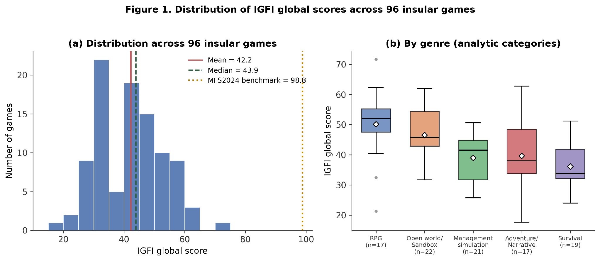
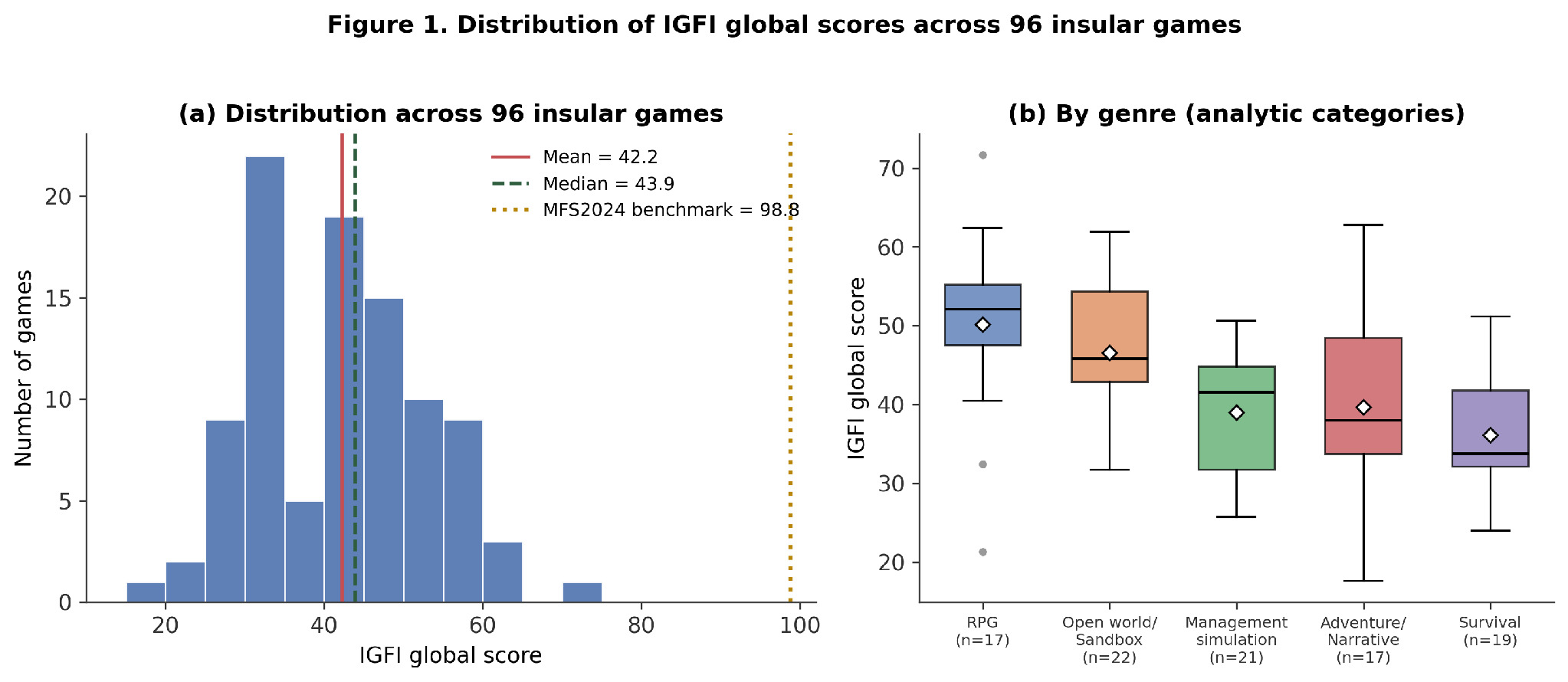
IGFI global scores across the 96 insular games range from 17.6 to 71.7. The mean is 42.2 (SD = 10.8) and the median 43.9. The distribution is approximately symmetrical (Figure 1). The benchmark, Microsoft Flight Simulator 2024, achieves 98.8, leaving a gap of 27.1 points between it and the highest-scoring conventional title, which constitutes a structural ceiling of geographic fidelity under current game design conventions.
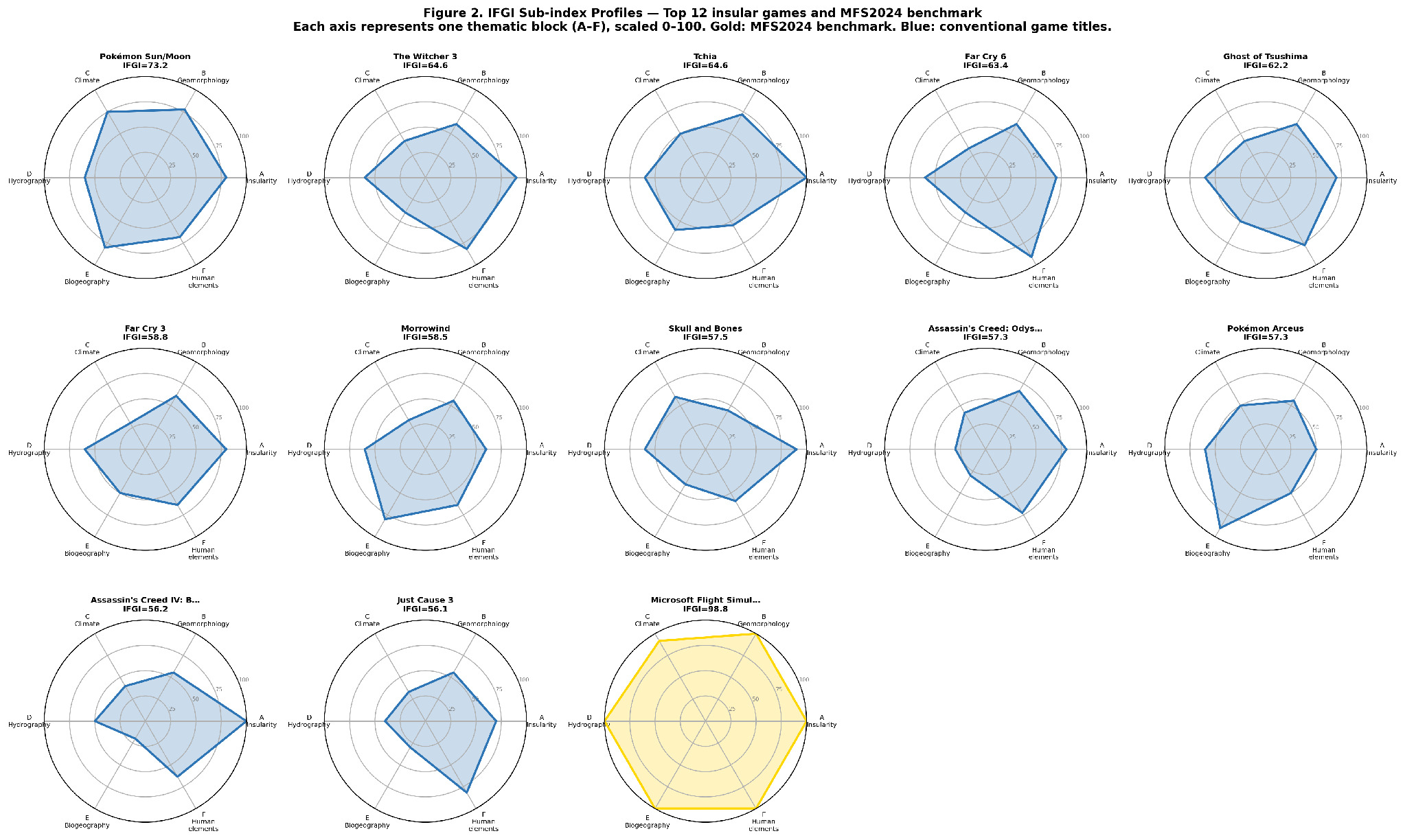
The ten highest IGFI scores among insular titles are led by Pokémon Sun and Moon (71.7). The remaining nine are Tchia (62.8), The Witcher 3: Wild Hunt (Skellige) (62.4), Far Cry 6 (61.9), Ghost of Tsushima (59.9), Far Cry 3 (57.6), Morrowind (57.0), Pokémon Legends: Arceus (56.2), Skull and Bones (56.1), and Assassin’s Creed: Odyssey (56.0). Pokémon Sun and Moon combines strong biogeographic representation (IGFI-E: 66.5) with the highest climate score in the corpus (IGFI-C: 75.3), a combination that reflects its explicit Hawaiian inspiration. The highest insularity score in the corpus (IGFI-A: 100.0) belongs to Tchia, which is based directly on the geography and culture of New Caledonia. At the bottom, Sea of Solitude (17.6), Pokémon Gold/Silver (Whirl Islands) (21.3), and Mist Survival (24.0) are the lowest-scoring insular titles.
The mean sub-index hierarchy across the 96 insular games displays a clear pattern. The order is: IGFI-A (69.1) ≫ IGFI-F (43.2) > IGFI-B (42.7) > IGFI-D (37.9) > IGFI-C (32.8) > IGFI-E (28.5). This hierarchy admits a direct interpretation in terms of islandness. Game designers consistently capture the form and human geography of islands. They systematically neglect, however, the island-specific climatic and ecological processes that define insular geographic identity.
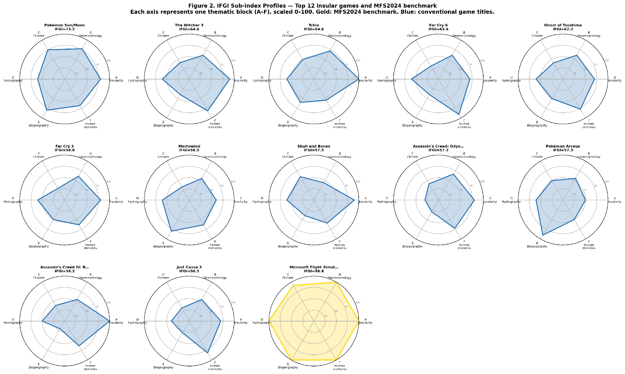
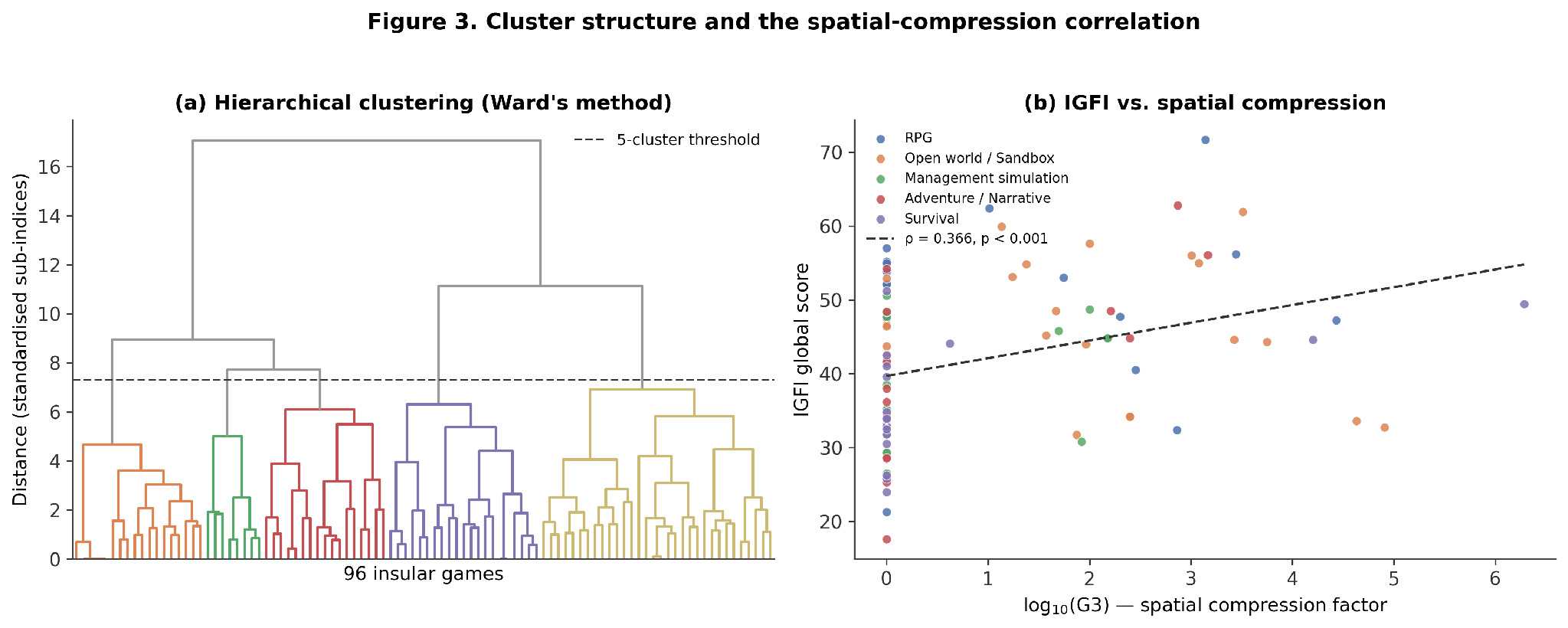
Hierarchical cluster analysis identified five groups, each with a distinct geographic representation profile (Figure 3). Group 1 (n = 18), labelled ‘human-centred island’, comprises management simulation and narrative open-world titles such as Tropico 6, Assassin’s Creed IV: Black Flag, Anno 1800, and Final Fantasy XV. It shows moderate-to-high IGFI-A and the highest IGFI-F of any cluster, with weak climate and biogeography. Group 2 (n = 8) is a small, distinctive group labelled ‘island without inland hydrography’. It includes The Legend of Zelda: Wind Waker, Stranded Deep, Subnautica: Below Zero, and Evil Genius 2, and scores zero on IGFI-D. It shows high insularity recognition but no represented drainage system at all, and very low human elements. Group 3 (n = 17), labelled ‘schematic trade-network island’, consists of management- and trade-focused titles such as the Anno series and Sunless Sea. It has low geomorphology and biogeography, with moderate climate and human elements. Group 4 (n = 21), labelled ‘isolation-first wilderness island’, is predominantly composed of survival titles such as The Witness, Survival: Fountain of Youth, ARK: Survival Evolved, and No Man’s Sky. It has the highest IGFI-A of any cluster, but the lowest IGFI-F. Group 5 (n = 32), the largest cluster, is labelled ‘geographically elaborated island’. It comprises the highest-scoring conventional titles, including Pokémon Sun and Moon, Tchia, The Witcher 3, and Far Cry 6. It is the only cluster with above-average scores across geomorphology, climate, hydrography, biogeography, and human elements simultaneously.
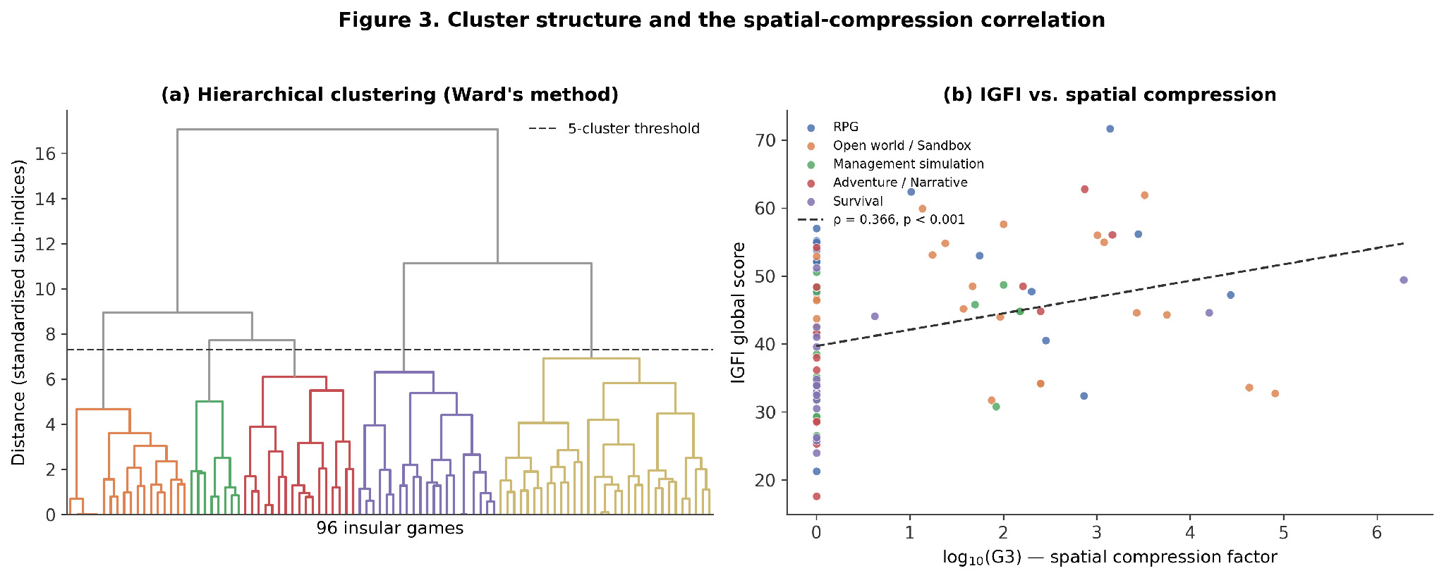
For the 96 insular games, the Spearman correlation between IGFI global scores and log₁₀(G3) is ρ = 0.366 (p < 0.001). This indicates a statistically significant positive relationship (Figure 3). Games with greater spatial compression tend to achieve higher, not lower, geographic fidelity. The correlation holds consistently across genre groups, and is not driven by outliers.
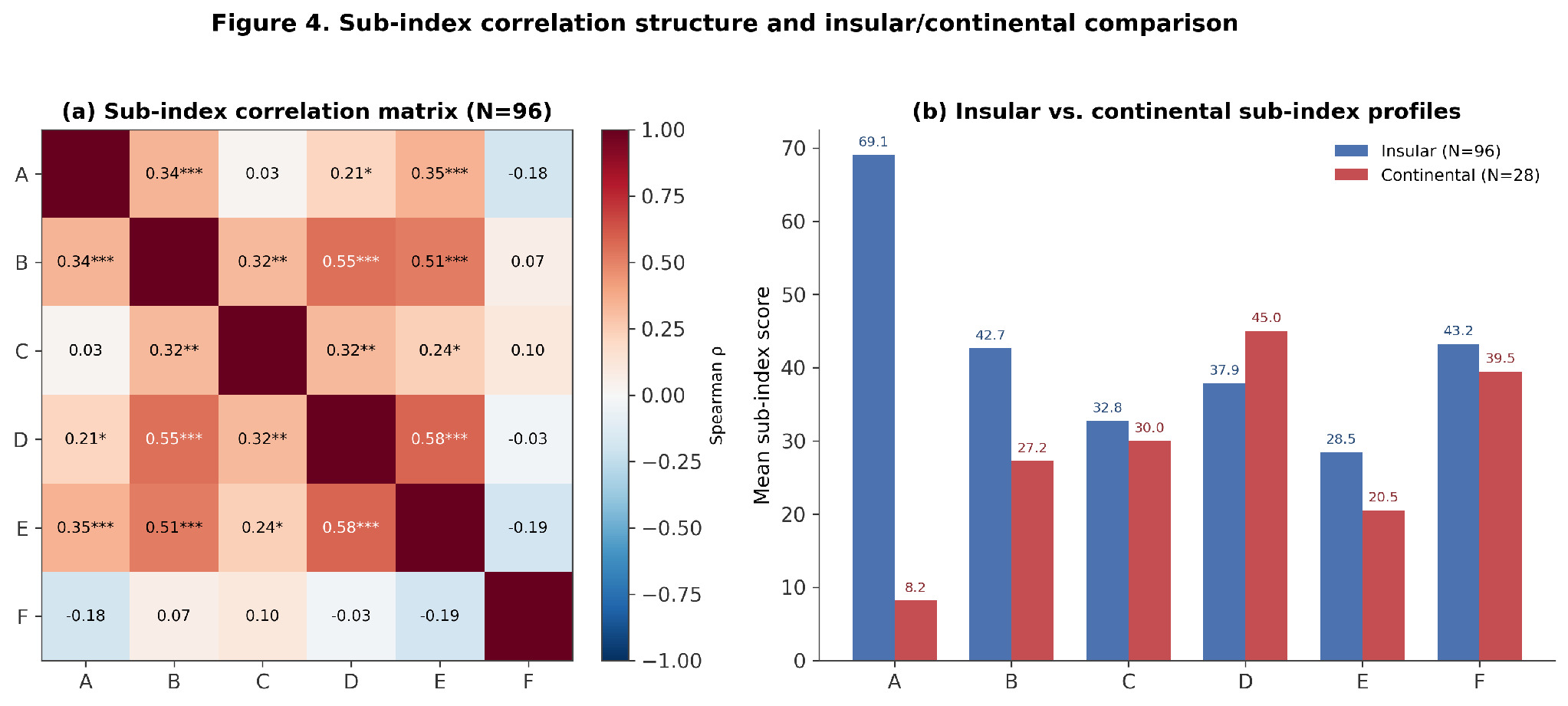
The Spearman correlation matrix of sub-indices (Figure 4) reveals a coherent natural-environment axis. This axis links hydrography, biogeography and geomorphology. IGFI-D and IGFI-E form the most strongly correlated pair in the matrix (ρ = 0.580, p < 0.001), with IGFI-B correlating strongly with both (ρ = 0.553 with D, ρ = 0.511 with E; all p < 0.001). By contrast, IGFI-F, which represents human elements, is not significantly correlated with any natural-environment block. The values are as follows: IGFI-B (ρ = 0.068, ns), IGFI-C (ρ = 0.102, ns), and IGFI-D (ρ = -0.030, ns). This indicates that island human geography follows a design logic essentially independent of physical geographic accuracy.
_spearman_correlation_matrix_of_igfi_sub-indices_a--f_across_96_insular_games_(_*_p__0.png)
4.3. Predictors and Comparisons
The Kruskal-Wallis test by genre yields H = 22.04, p = 0.0002, indicating significant differences across genres. The two genre labels with fewer than five titles, Shooter and Action RPG, were folded into their parent categories (Section 3.3). RPG games achieve the highest median IGFI (52.1), with comparatively balanced scores across geomorphology, hydrography, biogeography and human elements, rather than strength concentrated in a single domain. Management simulation games follow (median 41.5). Their scores are driven almost entirely by human elements (IGFI-F = 57.2), against the weakest natural-environment sub-indices of any genre (IGFI-D = 21.4, IGFI-E = 15.9). Survival games achieve the lowest median (33.8), despite the highest insularity recognition of any genre (IGFI-A = 75.3). This is because human elements collapse almost to zero (IGFI-F = 10.7). By contrast, the test by island type, restricted to the 96 insular games and covering real, fictitious, and fantastical categories, yields H = 4.50, p = 0.105, which is not significant. Ghost of Tsushima (Real) achieves no statistically higher geographic accuracy than The Witcher 3’s Skellige (Fictitious verisimilar). The test by geological origin compares the two categories with sufficient representation among insular titles, namely continental-shelf (n = 63) and volcanic (n = 27). Coralline and fantastical origins are too rare to test (n = 2 and n = 4, respectively). This test yields H = 0.64, p = 0.425, which is also not significant. Genre is the principal structural predictor of geographic fidelity. The typological characteristics of the island itself have no statistically demonstrable effect.
The 28 continental games score a mean IGFI of 31.0 (SD = 9.4), compared to 42.2 (SD = 10.8) for the 96 insular games (Figure 4). The Mann-Whitney U test confirms a highly significant difference (U = 2096.5, p < 0.0001). Sub-index analysis reveals that the gap concentrates in IGFI-A (69.1 insular vs. 8.2 continental) and IGFI-B (42.7 vs. 27.2), with a smaller gap in IGFI-E (28.5 vs. 20.5); IGFI-C (32.8 vs. 30.0) and IGFI-F (43.2 vs. 39.5) converge, and IGFI-D is in fact higher for continental games (45.0) than for insular ones (37.9), consistent with permanent river networks being a more plausible continental feature that the index rewards wherever it appears (Section 3.2). The index correctly identifies insularity recognition as overwhelmingly distinctive of insular geography. Geomorphology also differentiates insular from continental games, and biogeography does so to a lesser extent. Human elements and climate, by contrast, do not.
The mean IGFI for insular games does not rise steadily. Its trajectory is non-monotonic. It stands at approximately 32 for 1993 to 1997, dips to 33 for 2003 to 2007, and then rises to a plateau of around 45 to 46 through 2008 to 2017. It falls back to 41 for 2018 to 2022, before recovering to 43 in the most recent period, 2023 to 2025. Standard deviations within each quinquennium remain large, between 6 and 13 points. The earliest and latest bins rest on small samples, with n = 3 and n = 8 respectively, so neither extreme should be over-interpreted. No evidence exists of a steady or accelerating improvement over the three decades covered by the corpus. The gap with the MFS2024 benchmark (98.8) remains wide throughout the series.
5.0. Discussion
The most striking finding of this study, that IGFI-A achieves a mean of 69.1 while IGFI-E and IGFI-C score 28.5 and 32.8 respectively, constitutes what may be termed the islandness paradox of video game islands. Game designers systematically recognise and communicate the fundamental geographic form of insular territories: the bounded land surrounded by sea, the perceptible isolation, the coastline as limit. Yet they equally systematically neglect the geographic substance that makes islands distinct, in their islandness, from continental territories of comparable size.
Baldacchino (2004, p. 272) described the island as ‘a geographically finite, total, discrete, sharply precise physical entity’. It is precisely this face-value dimension, the finite, discrete form, that video games reproduce faithfully. What they fail to reproduce is everything that lies beneath that face value: the windward/leeward climatic asymmetry; the altitudinal vegetation belts; the biogeographic impoverishment and elevated endemism identified by MacArthur and Wilson (1967); the ephemeral drainage of volcanic islands. These are the properties through which, as Depraetere (2008) argued, islands constitute a distinct category of geographic object: a category that virtual islands, despite their visual sophistication, almost never instantiate.
Nyman (2013) observed that islands in video games function primarily as spatial containers: bounded worlds regulating player movement and narrative possibility. The present findings extend this into the physical geography domain: the island as container is precisely what game designers construct, while the island as ecological and climatic system remains unbuilt. This has a clear design rationality: the spatial boundedness of an island serves the gameplay need for a defined world, while climatic and ecological specificity serves no comparable mechanical function. A windward/leeward gradient does not make a more compelling shooter; a laurel forest does not enhance a management simulation. Geography is instrumentalised: the features that serve the game are represented; those that do not are omitted.
The absence of a statistically significant difference in IGFI between games set on real, fictional, and fantastical islands (H = 4.50, p = 0.105) is among the most theoretically consequential findings of this study. It implies that the decision to ground a game in a real geographic referent (Tsushima for Ghost of Tsushima, Hawaii for Pokémon Sun and Moon, Cuba for Far Cry 6) confers no systematic geographic advantage. A game set on a carefully researched real island does not, on average, represent that island’s climate, ecology, or hydrography more accurately than a game set on a fictional island with no real-world referent.
This is consistent with Fraile-Jurado (2024), where real settings also failed to predict geographic accuracy in open-world games. It points to a structural feature of the production process: geographic accuracy is not a design priority that propagates systematically through the pipeline even when a real referent is chosen. Between the decision to set a game on a Caribbean volcanic island and the final product lie layers of artistic direction, mechanical design, commercial targeting, and technical constraint that collectively determine which geographic features appear, and none of these layers is primarily oriented towards geographic fidelity.
Bogost’s (2007) concept of procedural rhetoric is illuminating here: games make arguments through their rules and mechanics, not their descriptive content. The argument a survival game makes about an island is about isolation, resource scarcity, and the human-environment struggle, equally effective through a fictional island as through a real one. The argument a management game makes about a Caribbean island is about political economy and governance, requiring no biogeographic accuracy to be persuasive. In this light, the geographic referent functions as a cultural sign rather than a geographic specification: Cuba in Far Cry 6 signals ‘tropical dictatorship’ to the player, not ‘high geological diversity with windward/leeward differentiation and endemic fauna’. The sign is reproduced; the geographic referent is not.
The positive Spearman correlation between spatial compression factor G3 and IGFI global scores (ρ = 0.366, p < 0.001) runs counter to the intuition that compressing a real geographic territory into a smaller playable map should degrade its geographic representation. It is proposed here that spatial compression in video game design functions analogously to generalisation in cartography.
Harley (1988) argued that maps are not neutral transcriptions of geographic reality but selective constructions that amplify certain features while suppressing others — and that this selectivity is not merely a technical necessity but an epistemological act. A well-generalised map at 1:1,000,000 may communicate the essential geographic structure of a territory more effectively than a poorly composed map at 1:50,000 that overwhelms with undifferentiated detail. The analogy to game design is direct: a developer who must compress Cuba (110,000 km2) into a 34 km2 playable map (Far Cry 6, G3 = 3,231) must make explicit selection decisions — which mountains, which coastal varieties, which vegetation zones — and these decisions tend to reproduce the most geographically salient features of the referent. A developer working with a large low-compression map may fill its space with generic procedural content requiring no geographic selection at all. This extends Fraile-Jurado’s (2024) finding that games with higher transit speeds tended to show higher geographic quality.
The strong genre effect (H = 22.04, p = 0.0002) and the absence of effects from island type and geological origin constitute a finding of considerable theoretical significance: what a player does with an island territory determines how that territory is represented, more than any intrinsic geographic property of the island itself. This may be termed the architecture of geographic attention: the idea that game genre structures which aspects of the geographic environment receive representational investment.
In management simulation games, the player administers an island economy. This involves ports, agricultural zones, population distribution, and roads. The features which matter for these activities are coastal access, agricultural land, urban hierarchy, and maritime connectivity. These are precisely the features which management games represent best, with the highest IGFI-F of any genre, at 57.2. Climate and biogeography, by contrast, have no direct mechanical role in city-building, and are the weakest of any genre (IGFI-C = 27.2, IGFI-E = 15.9). In survival games, the player navigates and extracts resources. Isolation is mechanically central, with the highest IGFI-A of any genre, at 75.3. The genre’s most severe weakness, however, lies not in climate, since survival games in fact achieve the highest IGFI-C of the five genres (37.3), but in human geography, which collapses almost to zero (IGFI-F = 10.7). This is because settlement, infrastructure, and economic dependence have no mechanical role in a narrative built around solitary or small-group struggle against an empty landscape.
This has a direct implication for the educational potential of video games as geographic media (Egenfeldt-Nielsen, 2006; Fraile-Jurado & Periáñez-Cuevas, 2023). Genre-specific geographic literacy, rather than general geographic accuracy, may be the appropriate evaluative framework: a management simulation could be a powerful tool for teaching island political economy; it would be a poor tool for teaching island biogeography or climate. A survival game could convey the experiential reality of island isolation; it would be unreliable on settlement patterns and economic infrastructure, the one domain where the genre’s representation collapses almost entirely.
Islands contain a disproportionate share of the world’s biodiversity: approximately 20% of all described bird, reptile, and plant species are endemic to islands, which cover less than 7% of the Earth’s land surface (Whittaker & Fernández-Palacios, 2007). More than 80% of all documented vertebrate extinctions since 1500 have occurred on islands (IUCN, 2022; Whittaker & Fernández-Palacios, 2007), the vast majority driven by introduced species (rats, cats, goats, pigs) whose devastating effects are a direct consequence of the biogeographic vulnerability theorised by MacArthur and Wilson (1967). Island ecosystems are also among the most exposed to climate change: rising sea levels, increasing cyclone intensity, and shifting precipitation patterns all disproportionately affect insular territories.
Against this backdrop, the finding that three billion video game players are regularly exposed to virtual islands that systematically misrepresent insular ecology and climate carries implications beyond academic geography. If the dominant popular representation of an oceanic island is a territory with large terrestrial mammals, permanent rivers, homogeneous vegetation, and no climatic asymmetry, as the data presented here suggest, then video games are constructing a mental model of insular geography that normalises precisely those features whose presence in real islands constitutes ecological catastrophe. A player who has internalised the virtual island as a place with wolves, bears, and flowing rivers has no intuitive basis for understanding why the introduction of a single rat population to a real oceanic island can collapse its entire bird community, or why the absence of large mammals is not a deficiency but a defining adaptive feature of oceanic island ecosystems.
This study does not argue that video games bear primary responsibility for geographic literacy deficits, nor that developers have a simple obligation to prioritise scientific accuracy over gameplay. What the evidence suggests is that the consistent and systematic nature of the representational gaps identified (across genres, platforms, decades, and island types) points not to random omission but to structural invisibility: the properties that constitute islandness are not present in the shared vocabulary of game design, and are therefore absent from its outputs regardless of the intentions or resources of individual developers. Addressing this structural invisibility requires, at minimum, making it visible, which is what the present study attempts to do.
6.0. Conclusions
This study has presented the first systematic geographic assessment of insular territory representation in video games, based on a corpus of 125 titles, a seven-block variable framework of 50 variables, and the Island Geographic Fidelity Index (IGFI). The findings converge on a coherent and interpretable picture of how virtual islands relate to their real-world geographic counterparts.
Virtual islands are recognisably insular: they are surrounded by sea, they convey isolation, and they organise human activity along the coast. They are often rendered with pronounced relief. Their styling, however, follows continental-shelf morphology more frequently than the volcanic templates which most real oceanic islands follow. Their human occupation is also detailed. In these respects, the virtual island of contemporary video games is a credible representation of the island as spatial form. Yet virtual islands are almost never authentic in their islandness: their climate ignores the windward/leeward gradient; their vegetation lacks altitudinal stratification and relict formations; their fauna is populated with large mammals that have no basis in oceanic island biogeography; their drainage follows continental models unrelated to the ephemeral hydrology of volcanic islands. The IGFI sub-index hierarchy (insularity (69.1) >> human elements (43.2) > geomorphology (42.7) > hydrography (37.9) > climate (32.8) > biogeography (28.5)), quantifies this pattern with precision.
Four conclusions of broader significance emerge. First, games set on real islands achieve no higher geographic fidelity than those set on fictional ones, demonstrating that the selection of a geographic referent is a cultural and commercial decision, not a commitment to geographic representation. Second, the genre effect confirms that the architecture of geographic attention in video games is determined by mechanical interaction rather than by the intrinsic properties of the geographic setting: games represent what their mechanics require players to notice. Third, the positive correlation between spatial compression and IGFI suggests that scale reduction in game design functions as geographic selection rather than geographic loss, with paradoxical effects on representational fidelity. Fourth, a structural gap separates insular from continental games in IGFI-A, and to a lesser extent in IGFI-B and IGFI-E. No such gap appears in IGFI-C or IGFI-F. This pattern confirms that the index correctly discriminates genuinely insular from merely coastal geographic representations.
These conclusions have implications for island studies, for game geography, and for the broader question of how geographic knowledge circulates through popular media. For island studies, this paper shows that the properties of islandness which Baldacchino, Depraetere, Royle and others identify as central to insular geographic identity have not penetrated the representational conventions of the world’s most consumed visual medium. For game geography, a replicable instrument for longitudinal and comparative research is provided by the IGFI framework. For geographic media literacy, the scale of the phenomenon is striking: three billion players regularly inhabit virtual islands that systematically misrepresent insular ecology and climate. This underscores the importance of understanding video games as geographic environments that shape how players conceptualise the natural world.
This study has three principal limitations. The expert panel comprised nine researchers (N = 9), a sample comparable to similar indicator-construction exercises in geographic research (Fraile-Jurado et al., 2024). Future research should seek larger panels for increased representativeness. Variable coding, while inter-rater validated (κ > 0.70), remains subject to observer interpretation for the most holistic variables. And the corpus, while the largest assembled for this type of study, is biased towards titles with English-language documentation; games from Asian, Latin American, and African studios are underrepresented. Future research directions include longitudinal tracking across hardware generations; analysis of whether developers from island nations or coastal regions produce virtual islands more faithful to islandness; audience reception studies examining whether players internalise virtual island geographies; and design-oriented intervention studies exploring whether geographic accuracy can coexist with commercial viability. Pokémon Sun and Moon and Tchia, the two highest-scoring conventional games in this study, suggest that it can.
Data availability statement
The coded data matrix and the category-to-score conversion table are available from the corresponding author upon reasonable request.
Acknowledgments
Artificial intelligence tools (Claude, Anthropic) were used for language editing and for the editing of figures and graphics during the preparation of this manuscript.